Magoar
|
Magoar Magor |
||
|---|---|---|
|
|
||
| region | Brittany | |
| Department | Cotes-d'Armor | |
| Arrondissement | Guingamp | |
| Canton | Callac | |
| Community association | Guingamp Paimpol Armor Argoat Agglomération | |
| Coordinates | 48 ° 24 ′ N , 3 ° 11 ′ W | |
| height | 223-296 m | |
| surface | 7.79 km 2 | |
| Residents | 86 (January 1, 2017) | |
| Population density | 11 inhabitants / km 2 | |
| Post Code | 22480 | |
| INSEE code | 22139 | |
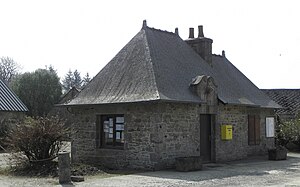
 Mairie Magoar |
||
Magoar ( Breton Magor ) is a French commune with a population of 86 (as at 1st January 2017) in the department of Côtes-d'Armor in the region of Brittany . It belongs to the arrondissement of Guingamp and the canton of Callac . The inhabitants are called Magoariens / Magoariennes .
geography
Magoar is about 33 kilometers southwest of Saint-Brieuc .
Population development
| year | 1793 | 1806 | 1821 | 1831 | 1861 | 1872 | 1876 | 1901 | 1906 | 1936 | 1962 | 1968 | 1975 | 1982 | 1990 | 1999 | 2006 | 2012 |
| Residents | 425 | 434 | 321 | 435 | 447 | 369 | 463 | 461 | 384 | 348 | 256 | 220 | 172 | 155 | 114 | 96 | 90 | 90 |
| Sources: Cassini and INSEE | ||||||||||||||||||
Attractions
- Saint-Gildas Church with Passion Window ( Monument historique )
literature
- Le Patrimoine des Communes des Côtes-d'Armor. Flohic Editions, Volume 1, Paris 1998, ISBN 2-84234-017-5 , pp. 79-80.
Web links
Commons : Magoar - collection of images, videos and audio files
