
Kermoroc'h
|
Kermoroc'h Kervoroc'h |
||
|---|---|---|
|
||
| region | Brittany | |
| Department | Cotes-d'Armor | |
| Arrondissement | Guingamp | |
| Canton | Bégard | |
| Community association | Guingamp Paimpol Armor Argoat Agglomération | |
| Coordinates | 48 ° 37 ′ N , 3 ° 12 ′ W | |
| height | 79-147 m | |
| surface | 6.16 km 2 | |
| Residents | 456 (January 1, 2017) | |
| Population density | 74 inhabitants / km 2 | |
| Post Code | 22140 | |
| INSEE code | 22091 | |

Kermoroc'h ([ kɛʁmoʁɔk ]; Breton : Kervoroc'h ) is a French commune with 456 inhabitants (as of January 1, 2017) in the Côtes-d'Armor department in the Brittany region . It belongs to the arrondissement of Guingamp and to the community association Guingamp Paimpol Armor Argoat Agglomération, founded in 2016 . The residents call themselves Kermorochois .
geography
The municipality of Kermoroc'h is located in the north of the Breton peninsula , eight kilometers north-northwest of the arrondissement capital Guingamp and about 30 kilometers southwest of the rose granite coast of the English Channel . The municipal area is drained by the Ruisseau du Poirier and Ruisseau de Grand Bois streams , which flow into the Théoulas , a tributary of the Jaudy .
The municipality of Kermoroc'h consists of the following villages and districts:
- Crec'h Mingant
- Douar Lavar
- Goat organism
- Kerbellec
- Kercadiou
- Keréven
- Kerfichet
- Kermoalquin
- Kersteven
- La Métairie Neuve
- Langouérat
- La Solaye
- La Villeneuve
- Le Guern
- Le Vieux Poirier
- Park Foën
- Park Névez
- Penn ar Run
- Porz Ru
- Poullo Pri
- Ruglaziou
- Toul ar Hoat
- Traoun to Ouas
as well as from numerous nameless little hamlets and individual farms. The village of Kermoroc'h with the town hall and church is located in the northwest of the municipality.
The landscape around Kermoroc'h is characterized by arable and grassland areas, which are separated from each other by the hedges typical of the area. Apart from the slopes on steep sections of the river, the municipality is almost free of forests.
Neighboring communities of Kermoroc'h are Landebaëron in the north, Squiffiec in the northeast, Trégonneau in the east, Plouisy in the south and Saint-Laurent in the west.
history
The place name Kermoroc'h is made up of the Breton terms “Ker” (= village) , “Mor” (= sea) and “Roc'h” (= rock) . The origin via a personal name (morech, moroch) is also possible. The municipality of Kermoroc'h ( called Kmorch from 1793 to 1801 ) has remained unchanged since 1793.
Population development
| year | 1962 | 1968 | 1975 | 1982 | 1990 | 1999 | 2006 | 2017 | |
| Residents | 344 | 326 | 284 | 283 | 268 | 324 | 376 | 456 | |
| Sources: Cassini and INSEE | |||||||||
Attractions
- Castle (Château du Poirier)
- Church of Sainte-Brigitte
- The Saint-Louis chapel in the Langouérat district, the old parish church of Longouérat from the 14th to the 17th century, with the last restoration in 1645, fell into disrepair in the middle of the 20th century. Since 2004 an association has committed itself to repairing and maintaining the chapel.
- Calvaire in front of the Saint-Louis chapel from the 17th century, Monument historique
- Botanical nature trail along the Poirier bank between Kermoroc'h and Landebaëron with numerous sculptures

Saint-Louis Chapel 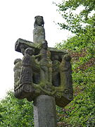
Calvaire in front of the Saint-Louis chapel 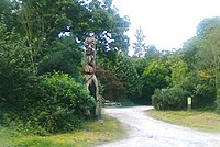
Totem sculpture on the botanical nature trail


Economy and Infrastructure
The main economic branch of the municipality is still agriculture. There are twelve farms in the municipality (grain cultivation, dairy farming, cattle and poultry farming). In addition, tourism is also developing with the creation of some guest houses and holiday homes.
Kermoroc'h is located off the major national transport routes. Six kilometers southwest of Kermoroc'h there is a connection to the highway D 767 from Guingamp to Lannion . The nearest train station is in Squiffiec, three kilometers away, on the Guingamp- Paimpol railway line .
literature
- Le Patrimoine des Communes des Côtes-d'Armor. Flohic Editions, Volume 1, Paris 1998, ISBN 2-84234-017-5 , pp. 43-44.
supporting documents
- ↑ Origin of the name from books.google.de
- ↑ Kermoroc'h on cassini.ehess.fr
- ↑ Kermoroc'h on insee.fr
- ^ Entry in the Base Mérimée of the Ministry of Culture. Retrieved November 15, 2015 (French).
- ↑ Farms on annuaire-mairie.fr (French)