Kerpert
|
Kerpert Kerbêr |
||
|---|---|---|
|
|
||
| region | Brittany | |
| Department | Cotes-d'Armor | |
| Arrondissement | Guingamp | |
| Canton | Callac | |
| Community association | Guingamp Paimpol Armor Argoat Agglomération | |
| Coordinates | 48 ° 25 ′ N , 3 ° 4 ′ W | |
| height | 177-301 m | |
| surface | 21 km 2 | |
| Residents | 270 (January 1, 2017) | |
| Population density | 13 inhabitants / km 2 | |
| Post Code | 22480 | |
| INSEE code | 22092 | |
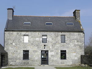
 Mairie Kerpert |
||
Kerpert ( Breton : Kerbêr ) is a French commune with 270 inhabitants (as of January 1, 2017) in the Côtes-d'Armor department in Brittany . It belongs to the arrondissement of Guingamp and the municipality association Guingamp Paimpol Armor Argoat Agglomération .
geography
The municipality of Kerpert is located 23 kilometers south of Guingamp and 33 kilometers southwest of Saint-Brieuc . South of the core town of Kerpert, between the districts of Garz an Cloarec and Kerhars, the 72 kilometer long Trieux (Breton: Trev ) coastal river rises .
Other districts of Kerpert are Kergolou, Coldesquient, Keranquere, Kerlahaye, Lesquiolec, Toullfoll, Guerniou, Kertanguy, Pempoulou, Kergrist ar Lann, Kerlabourat, Kerhelvez, Kerlabourlay, Saint-Urnan, Kerdrain, Coldevennhö and numerous small hamlets and Bot ar Guen .
The landscape around Kerpert is characterized by arable and grassland areas, which are separated from each other by the hedges typical of the area. Apart from the slopes on steep sections of the river, the area is poorly forested; only in the north does the municipality have the largest share of the approximately 150 hectare Bois de Coat Mallouen .
Neighboring municipalities of Kerpert are Plésidy in the north, Saint-Connan in the northeast, Saint-Gilles-Pligeaux in the east, Canihuel in the southeast, Saint-Nicolas-du-Pélem in the southwest, Lanrivain in the west and Magoar in the northwest.
history
Kerpert and the surrounding towns were built in the middle of the 12th century at the time of the founding of the Coëtmaloën Abbey . The municipality of Kerpert ( called Pert in 1801 ) has remained unchanged since 1793.
Population development
| year | 1962 | 1968 | 1975 | 1982 | 1990 | 1999 | 2006 | 2017 | |
|---|---|---|---|---|---|---|---|---|---|
| Residents | 530 | 469 | 400 | 400 | 331 | 317 | 301 | 270 | |
| Sources: Cassini and INSEE | |||||||||
Attractions
- Ruins of the Cistercian Abbey of Coëtmaloën , founded in 1142 as a subsidiary of the Cîteaux monastery, Monument historique
- St. Peter's Church ( Église Saint-Pierre ) from the 16th century including ossuary ( ossuaire ) on which the Church surrounding cemetery, monument historique
- Marian relief from the 19th century
- Chapel in the Kergrist ar Lann district, built in 1755 and initially part of the parish of the neighboring parish of Magoar; Destroyed in 1860 and rebuilt after being acquired by the Kerpert community in 1872. The neighboring Calvary, which was partially destroyed during the French Revolution, has its origins in the 15th century.
- Lavoir and various fountains
- Farm ( Ferme de Saint-Urnan ) in the district of Saint-Urnan from the 17th century
- Dolmen de Kéranquéré from the Neolithic Age
Economy and Infrastructure
The main economic branch of the municipality is still agriculture. There are 33 farms in the municipality (cereal cultivation, dairy farming, cattle, sheep, goats and poultry farming, pig farming).
Kerpert is located off the main national transport routes. The trunk road from Saint-Brieuc to Rostrenen (D 790) runs a few kilometers south of Kerpert . The nearest train station is in Guingamp, 23 kilometers away .
literature
- Le Patrimoine des Communes des Côtes-d'Armor. Flohic Editions, Volume 2, Paris 1998, ISBN 2-84234-017-5 , pp. 1247-1249.
supporting documents
- ↑ Kerpert on cassini.ehess.fr
- ↑ Kerpert on insee.fr
- ^ Entry in the Base Mérimée of the Ministry of Culture. Retrieved January 22, 2015 (French).
- ^ Entry in the Base Mérimée of the Ministry of Culture. Retrieved January 22, 2015 (French).
- ↑ Description on patrimoine.region-bretagne.fr (French)
- ↑ Farms on annuaire-mairie.fr (French)


