
Saint-Péver
|
Saint-Péver Sant-Pever |
||
|---|---|---|
|
||
| region | Brittany | |
| Department | Cotes-d'Armor | |
| Arrondissement | Guingamp | |
| Canton | Plélo | |
| Community association | Leff Armor Community | |
| Coordinates | 48 ° 29 ′ N , 3 ° 6 ′ W | |
| height | 89-204 m | |
| surface | 13.13 km 2 | |
| Residents | 402 (January 1, 2017) | |
| Population density | 31 inhabitants / km 2 | |
| Post Code | 22720 | |
| INSEE code | 22322 | |
 View of Saint-Péver |
||

Saint-Péver is a French municipality with 402 inhabitants (as of January 1 2017) in Côtes-d'Armor in the region of Brittany ; it belongs to the arrondissement of Guingamp and the canton of Plélo (until 2015: canton of Plouagat ). The inhabitants are called Pévérois .
geography
Saint-Péver is about ten kilometers south-southeast of Guingamp . The Trieux River runs along the eastern border of the municipality . Saint-Péver is surrounded by the neighboring communities of Ploumagoar in the north and north-west, Lanrodec in the east and north-east, Saint-Fiacre in the south and south-east, Plésidy in the west and south-west and Saint-Adrien in the west.
Population development
| year | 1962 | 1968 | 1975 | 1982 | 1990 | 1999 | 2006 | 2013 |
|---|---|---|---|---|---|---|---|---|
| Residents | 351 | 358 | 329 | 303 | 316 | 328 | 350 | 404 |
Attractions
See also: List of the Monuments historiques in Saint-Péver
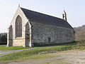
- Saint-Pierre church
- Notre-Dame chapel in Restudo, built at the end of the 14th century, monument historique since 1954
- Notre-Dame chapel in Avaugour, built between 1454 and 1504, monument historique since 1957

Saint-Pierre church

Notre-Dame chapel in Restudo
Notre-Dame chapel in Avaugour

_Chapelle_Notre-Dame-de-Restudo_04.JPG)
_Chapelle_Notre-Dame-d%27Avaugour_02.JPG)
literature
- Le Patrimoine des Communes des Côtes-d'Armor. Flohic Editions, Volume 2, Paris 1998, ISBN 2-84234-017-5 , pp. 970-973.
Web links
Individual evidence
- ↑ INSEE survey 2012 ( page no longer available , search in web archives ) Info: The link was automatically marked as defective. Please check the link according to the instructions and then remove this notice.