Saint-Agathon
|
Saint-Agathon Sant-Eganton |
||
|---|---|---|
|
|
||
| region | Brittany | |
| Department | Cotes-d'Armor | |
| Arrondissement | Guingamp | |
| Canton | Guingamp | |
| Community association | Guingamp Paimpol Armor Argoat Agglomération | |
| Coordinates | 48 ° 34 ′ N , 3 ° 6 ′ W | |
| height | 80-146 m | |
| surface | 14.56 km 2 | |
| Residents | 2,273 (January 1, 2017) | |
| Population density | 156 inhabitants / km 2 | |
| Post Code | 22200 | |
| INSEE code | 22272 | |
| Website | http://www.ville-saintagathon.fr/ | |
Saint-Agathon ( Breton Sant-Eganton ) is a French municipality with 2273 inhabitants (as of January 1 2017) in the department of Côtes-d'Armor in the region of Brittany . It belongs to the district Guingamp and eponymous canton Guingamp . The inhabitants are called Saint-Agathonnais .
geography
Saint-Agathon is about 30 kilometers west of Saint-Brieuc . Saint-Agathon is surrounded by the neighboring communities of Pommerit-le-Vicomte in the north, Le Merzer in the northeast, Saint-Jean-Kerdaniel in the east, Ploumagoar in the south and southwest, Guingamp in the west and Pabu in the west and northwest.
The National Route 12 runs through the municipality .
Population development
| year | 1962 | 1968 | 1975 | 1982 | 1990 | 1999 | 2006 | 2012 |
|---|---|---|---|---|---|---|---|---|
| Residents | 899 | 890 | 1.106 | 1,331 | 1,453 | 1,783 | 1,973 | 2,180 |
Attractions
- Notre-Dame Church , built after the French Revolution
- Notre-Dame chapel of Malaunay (built 1702–1704)
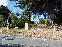
- The five Gallic steles, stone group from the Iron Age, Monument historique since 1958
- Mansion Kerleino from the 15th century
- Mansion Kérenez with dovecote
- Kerlann mansion from 1661, renovations in the 19th and 20th centuries. century
- Kermorvan mill from the 18th century
- several more windmills
literature
- Le Patrimoine des Communes des Côtes-d'Armor. Flohic Editions, Volume 1, Paris 1998, ISBN 2-84234-017-5 , pp. 422-423.
Web links
Commons : Saint-Agathon - Collection of images, videos and audio files

