
Pabu (Cotes-d'Armor)
|
Pabu Pabu |
||
|---|---|---|
|
||
| region | Brittany | |
| Department | Cotes-d'Armor | |
| Arrondissement | Guingamp | |
| Canton | Guingamp | |
| Community association | Guingamp Paimpol Armor Argoat Agglomération | |
| Coordinates | 48 ° 35 ′ N , 3 ° 8 ′ W | |
| height | 50-137 m | |
| surface | 7.84 km 2 | |
| Residents | 2,760 (January 1, 2017) | |
| Population density | 352 inhabitants / km 2 | |
| Post Code | 22200 | |
| INSEE code | 22161 | |
| Website | http://www.ville-pabu.fr/ | |
 Pabu City Hall |
||

Pabu [ paby ] ( Breton pabu ) is a French municipality with 2,760 inhabitants (as of January 1 2017) in the department of Côtes-d'Armor in the region of Brittany . It belongs to the district Guingamp and eponymous canton Guingamp . The inhabitants are called Pabuais (es) .
geography
Pabu is bounded to the west by the Trieux River . Pabu is surrounded by the neighboring communities of Trégonneau in the northwest, Pommerit-le-Vicomte in the northeast, Saint-Agathon in the east and southeast, Guingamp in the south and Plouisy in the west.
Population development
| year | 1962 | 1968 | 1975 | 1982 | 1990 | 1999 | 2006 | 2012 |
|---|---|---|---|---|---|---|---|---|
| Residents | 1,592 | 1,739 | 2,452 | 2,871 | 2,772 | 2,675 | 2,832 | 2,799 |
Attractions
- Church Saint-Tugdual , total in the 18th century created (1711-1762), restored mid-19th century
- Saint-Loup Chapel
- Munehorre Castle built in the 15th, rebuilt in the 17th century
- Runevarec Castle , built on the remains of an earlier manor house in the 19th century
- Grand Kermin mansion
- Old Guingamp Aqueduct
- Watermill Kerhré

Saint-Loup Chapel

Munehorre Castle
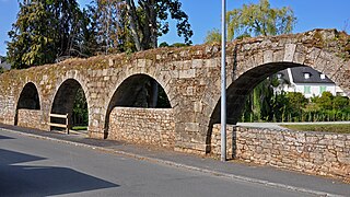
Guingamp Aqueduct

Old watermill from Kerhré am Trieux


Sports
Since 2016, the community has hosted the youth and training center called "Akademi" of the professional football club En Avant Guingamp .
Personalities
- Polig Monjarret (1920–2003), musician and art collector
- Cyril Gautier (* 1987), racing cyclist
- Robin Le Normand (born 1996), football player
literature
- Le Patrimoine des Communes des Côtes-d'Armor. Flohic Editions, Volume 1, Paris 1998, ISBN 2-84234-017-5 , pp. 416-418.
Web links
proof
- ↑ Article “ Guingamp will play next season in the 'Akademi' ” from May 29, 2018 at footofeminin.fr