
Pléguien
|
Pléguien Plian |
||
|---|---|---|
|
||
| region | Brittany | |
| Department | Cotes-d'Armor | |
| Arrondissement | Guingamp | |
| Canton | Plouha | |
| Community association | Leff Armor Community | |
| Coordinates | 48 ° 38 ′ N , 2 ° 56 ′ W | |
| height | 52-109 m | |
| surface | 15.48 km 2 | |
| Residents | 1,325 (January 1, 2017) | |
| Population density | 86 inhabitants / km 2 | |
| Post Code | 22290 | |
| INSEE code | 22177 | |

Pléguien ( Breton : plian ) is a French municipality with 1,325 inhabitants (as of January 1 2017) in the department of Côtes-d'Armor in the region of Brittany . Residents of the commune are called Pléguiénais .
geography
Pléguien is surrounded by the municipality of Plouha in the north, Plourhan in the east, Tréguidel in the south and Lanvollon in the west.
Population development
| 1962 | 1968 | 1975 | 1982 | 1990 | 1999 | 2008 | 2012 |
| 801 | 916 | 826 | 816 | 824 | 1.011 | 1,114 | 1,264 |
Attractions
- Bois de la Salle Castle in Pléguien with pigeon tower , built in 1702 ( Monument historique )

Castle front
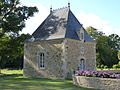
chapel

Lock from the side

Pigeon tower


Personalities
Born in Pléguien
- Vefa de Saint-Pierre (1872–1967), writer
Associated with Pléguien
- Raymond Boizard (1938–1983), member of the Lanvollon-Plouha General Council and member of the Parti socialiste , died in 1983 in Pléguien
literature
- Le Patrimoine des Communes des Côtes-d'Armor. Flohic Editions, Volume 1, Paris 1998, ISBN 2-84234-017-5 , pp. 562-564.
Web links
Commons : Pléguien - collection of images, videos and audio files
- Municipalities in France: Pléguien (French)
- Lanvollon Plouha community association: Pléguien (French)
Individual evidence
- ↑ Population statistics for Pléguien at INSEE , accessed on April 19, 2015 (French)
- ↑ Bois de la Salle Castle ( Memento of the original from December 22, 2015 in the Internet Archive ) Info: The archive link has been inserted automatically and has not yet been checked. Please check the original and archive link according to the instructions and then remove this notice. , accessed on April 19, 2015 (French)