Kostomlaty pod Milešovkou
| Kostomlaty pod Milešovkou | ||||
|---|---|---|---|---|
|
||||
| Basic data | ||||
| State : |
|
|||
| Region : | Ústecký kraj | |||
| District : | Teplice | |||
| Area : | 1115.0207 ha | |||
| Geographic location : | 50 ° 33 ' N , 13 ° 52' E | |||
| Height: | 405 m nm | |||
| Residents : | 931 (Jan. 1, 2019) | |||
| Postal code : | 417 54 | |||
| License plate : | U | |||
| traffic | ||||
| Street: | Žalany - Duchcov | |||
| structure | ||||
| Status: | local community | |||
| Districts: | 2 | |||
| administration | ||||
| Mayor : | Eva Krejsková (as of 2013) | |||
| Address: | Lhenická 310 417 54 Kostomlaty pod Milešovkou |
|||
| Municipality number: | 567612 | |||
| Website : | www.kostomlatypm.wz.cz | |||
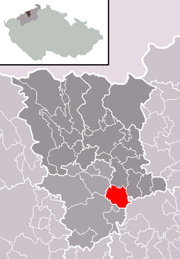
| Location of Kostomlaty pod Milešovkou in the Teplice district | ||||

|
||||
Kostomlaty pod Milešovkou (German Kostenblat , formerly Kostenblatt ) is a municipality in the Czech Republic . It is located seven kilometers east of Bílina and belongs to the Okres Teplice .
geography
Kostomlaty is located in the west of the Bohemian Central Uplands at the foot of the Sukoslav castle ruins in the headwaters of the Luční potok. The Milešovka (836 m) rises to the east and the Pařez (736 m) to the south.
Neighboring towns are Lhenice and Mošnov in the north, Bukovice and Hlince in the Northeast, Černčice the east, Milešov the southeast, Lukov and Štěpánov in the south, Ražice and Kučlín in the southwest, Bílina -Pražské Předměstí and Bílina-Teplické Předměstí in the west and Štrbice, Světec and Úpoř in the northwest.
To the southwest lies the Radovesický vysýpka waste dump. The villages of Hetov ( Hettau ), Dřinek ( Trinka ), Radovesice ( Radowesitz ) and Lyskovice ( Liskowitz ) used to be in their place.
history
Sukoslav Castle and the village of Kostomlaty were first mentioned when Boresch IV von Riesenburg sold the rule to Chotibor von Hirschstein in 1333 . The church was probably founded in the 13th century and is attributed to Bohuslav I. von Hrabischitz . The village built around the church was on the medieval trading path from Brüx to Aussig . After Jakoubek z Vřesovic conquered the castle in 1434, he bought the rule of Albrecht Berka von Dubá in 1435 . Kostomlaty was granted city rights at the transition from the 15th to the 16th century. At the beginning of the 17th century the castle fell into desolation. The Lords of Vřesovice held Kostomlaty until the Thirty Years' War. In 1623 Humprecht Czernin von Chudenitz acquired the rule. In 1629 the parish in Kostenblatt went out and the church of St. Laurentius became a branch church. In the Thirty Years War, the city rights were lost because the number of houses had become too small. Humprecht Johann Czernin von Chudenitz had the Humprechtwiese Castle built in 1670. After the death of his widow Diana, the rule was passed to the Count Clary-Aldringen in 1687 . In 1706 the parish was rebuilt in the cost sheet. In 1770, Countess Wilhelmine von Věžník bought the estate Kostenblatt. The Counts of Ledebur acquired the property from their daughter Antonia .
After the abolition of patrimonial cost sheet / Kostomlaty with the districts Tschentschitz / Černčice and Lischen / Hlince from 1850 formed a municipality in the Teplitz district . In 1888 a women's reformatory was set up in Humprechtswiese Castle. At the end of the 19th century it was assigned to the Duchcov district. The Czech name Kostomlaty was expanded in 1921 to distinguish it from villages of the same name with the addition of pod Milešovkou . In 1930 there were 1,809 inhabitants in the community.
After the Munich Agreement , the village was added to the German Reich and belonged to the district of Bilin from 1939 to 1945 . In 1939, 1531 people lived in Kostenblatt with Linschen and Tschentschitz. After the end of the Second World War, the place came back to Czechoslovakia. The population of the place was forcibly expelled as part of the expulsion of the Germans from Czechoslovakia . The district of Černčice was renamed to Žalany in 1961 .
Community structure
The municipality Kostomlaty pod Milešovkou consists of the districts Hlince ( Linschen ) and Kostomlaty pod Milešovkou ( Kostenblat ). The municipality forms the cadastral district Kostomlaty pod Milešovkou.
Attractions
- Ruins of Sukoslav Castle
- Kostomlaty pod Milešovkou Castle ( Humprechtswiese ), built in 1670 for Humprecht Johann Czernin von und zu Chudenitz . The castle has served as a closed facility for women since 1888 and is not accessible.
- Church of St. Lawrence, built around 1230 as a Romanesque building, in 1657 it was rebuilt. It was given its current baroque appearance in 1737 by Octavio Broggio .
- Lady Chapel at the miraculous spring in Kostomlaty, consecrated in 1825
- Chapel in Hlince
- Josephstein (Josefův kámen), memorial obelisk for Emperor Joseph II built in 1779, south of the village on a hill below the Pařez
Web links
Individual evidence
- ↑ http://www.uir.cz/obec/567612/Kostomlaty-pod-Milesovkou
- ↑ Český statistický úřad - The population of the Czech municipalities as of January 1, 2019 (PDF; 7.4 MiB)
- ↑ http://www.uir.cz/casti-obce-obec/567612/Obec-Kostomlaty-pod-Milesovkou
- ↑ http://www.uir.cz/katastralni-uzemi/670669/Kostomlaty-pod-Milesovkou


