
Krumpendorf am Wörthersee
|
Krumpendorf am Wörthersee
|
||
|---|---|---|
| coat of arms | Austria map | |
 |
|
|
| Basic data | ||
| Country: | Austria | |
| State : | Carinthia | |
| Political District : | Klagenfurt-Land | |
| License plate : | KL | |
| Surface: | 11.85 km² | |
| Coordinates : | 46 ° 38 ' N , 14 ° 13' E | |
| Height : | 450 m above sea level A. | |
| Residents : | 3,453 (January 1, 2020) | |
| Postal code : | 9201 | |
| Area code : | 04229 | |
| Community code : | 2 04 15 | |
| NUTS region | AT211 | |
| Address of the municipal administration: |
Hauptstrasse 145 9201 Krumpendorf |
|
| Website: | ||
| politics | ||
| Mayoress : | Hilde Gaggl ( ÖVP ) | |
|
Municipal Council : ( 2015 ) (23 members) |
||
| Location of Krumpendorf am Wörthersee in the Klagenfurt-Land district | ||
  |
||
 Krumpendorf am Wörthersee with the Falkenberg in the background |
||
| Source: Municipal data from Statistics Austria | ||

Krumpendorf am Wörthersee ( Slov. Kriva Vrba ) is an Austrian municipality on the Wörthersee with 3453 inhabitants (as of January 1, 2020) in the state of Carinthia .
geography
Krumpendorf is located in the south of Austria in the Carinthian Unterland on the north bank of the Wörthersee and borders on the provincial capital Klagenfurt . The municipal area extends over a relatively narrow strip on the lakeshore that extends over the Nohrenberg, and with an area of 11.89 km² is the smallest in the federal state of Carinthia.

Community structure
The community is divided into four cadastral communities (Pritschitz, Krumpendorf, Drasing and Gurlitsch II) and includes the following five localities (population as of January 1, 2020):
- Goertschach (112)
- Krumpendorf ( Kriva Vrba ) (3226)
- Nussberg (22)
- Pritschitz ( Pričiče ) (60)
- Tultschnig ( Cajnče ) (33)
(Gurlitsch I is a cadastral municipality in the neighboring municipality of Klagenfurt.)
Other locations are the settlements Am Föhrenwald , Brenndorf and Pirk as well as the Rotte Leinsdorf .
Neighboring communities
| Moosburg | ||
| Pörtschach |
.svg)
|
Klagenfurt |
| Maria Wörth |
history
Krumpendorf was first mentioned in a document in 1216 as Chrumpendorf . The name is likely to be derived from Krumpenfelferdorf , where Felfer was a dialectal name for willow (the expression krump stands for crooked ). The Slovenian name for the place ( Kriva Vrba ) is also derived from crooked willow (an alternative name is Podvrbo , i.e. under the willow ).
Krumpendorf was dominated by agriculture until, in the last two decades of the 19th century, summer tourism, starting from Pörtschach , also reached the localities of the municipality and changed them permanently.
The boundaries of today's municipality were set as early as 1573. The local community was constituted in 1850. In 1920 its share in the village of St. Primus and in 1938 the newly formed cadastral community Gurlitsch was added to the neighboring provincial capital of Klagenfurt. Since 1987, the municipality has had the addition “am Wörther See” in its name, which on July 1, 2012 was changed to “am Wörthersee”.
population
The census of May 15, 2001 showed a resident population of 2848, with 46.6% women and 53.4% men.
94.0% of the population have Austrian citizenship; of the foreign nationalities, residents from Germany (1.8%) and Bosnia-Herzegovina (1.0%) have the largest share. 94.3% of the citizens stated German as a colloquial language. The second largest language group is Croatian (1.6%), followed by Slovenian (1.1%).
70.8% of the citizens profess the Roman Catholic and 10.2% Protestant Church. 0.8% are Muslims and 13.4% have no religious beliefs.
Culture and sights


- Catholic parish church Krumpendorf Christkönig: The church stands on a hill in the west of Krumpendorf. Instead of a previous church, St. Georg between 1959 and 1962.
- Catholic branch church Pirk hl. Ulrich: The essentially Romanesque choir tower church with a four-story tower is located in the former village of Pirk. It was first mentioned in a document in 1321 and originally probably belonged to Maria Wörth or Viktring , from 1466 it was subordinate to the Maria Saal parish . Today it is a branch church of the Krumpendorf parish. Today nothing can be seen of the fortification of the former fortified church.
- Catholic branch church Tultschnig hl. John the Baptist
- The Martin Luther Church is a tent-like, small building that was built and consecrated in 1969.

Martin Luther Church on Südbahnweg

- Castles
- The Drasing Castle , north of Krumpendorf located on a wooded hill, is a three-story, castle-like renaissance. In its place there was probably already a previous building during the Carolingian era, which served as a bailey to the Palatinate Moosburg . Drasing Castle was mentioned in a document in 1284 and 1362. The building was originally built around the middle of the 14th century and received its present form in the course of the 16th century. The castle was repaired in 1842/43 and restored again from 1994 to 1996. It is privately owned.
- The Krumpendorf Castle on the main street in Krumpendorf was built in 1735-1740.
- Hornstein Castle is located on a wooded slope north of Krumpendorf. It was built by Ulrich Hornsteiner in the 15th century and is now privately owned.
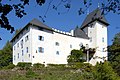
Drasing Castle

Krumpendorf Castle

Hornstein Castle


- Buildings of the Wörthersee architecture
- Lake restoration , 1902, client: Mayor Josef Pamperl
- Villa Madile , 1890 (formerly Villa Freiherr Basso von Gödel-Lannoy), Vogelberg 26, design and execution: city architect Franz Madile
- Bahnhofhotel , (today Kärntnerhof), Krumpendorf, Hauptstrasse
- Cafe Dvorsky , Hauptstrasse 136, designed by Karl Maria Kerndle in 1927
- Villa Haybäck , Am Hang 6, designed by Karl Haybäck in 1902/03
- Haus Schindler , Kaiserallee 28, designed by Franz Baumgartner in 1911/12
- Villa Schwalbennest (formerly Villa Janesch), Berthastrasse 59, designed by Friedrich Siegmundt, 1888/89
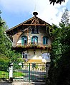
Villa Haybäck, Am Hang 6

House Schindler at Kaiserallee 28

Villa Schwalbennest at Berthastraße 59


- Other structures
- A milestone has been set up next to a well on the Südbahnweg in the west of the municipality ; it bears the inscription 1 mile from Klagenfurt . Almost certainly one Austrian post mile is meant, about 7.586 km. This corresponds to the distance from the then outskirts of Klagenfurt to this marking point on the cycle path to Pörtschach .
- Gut Walterskirchen : There was some controversy and political bickering about the sale of the Walterskirchen estate from the state of Carinthia to the timber industrialist Hans Tilly. The expansion and conversion of the former building into a feudal retirement home could not be prevented despite the legal provisions. Several trees from the previously dense tree population were felled. In 2008 the old manor house was demolished and a new building was erected in its place, which was completed in 2009. At the southern headland of the estate on the banks of the Wörthersee there is a wooden tower, a structure clad with clapboard-like larch boards, which is very clearly visible from the southern bank of the Wörthersee.
- The listed empty scrap tower from 1818 has belonged to Klagenfurt (Villacher Strasse 354) since 1938 through an incorporation. See list for details

Fountain with a milestone on the Südbahnweg

Building of Gut Walterskirchen

Lookout tower at Gut Walterskirchen


Natural monuments
- Weiberzahn North of the Walterskirchen estate in the Pritschitz district in the Föhrenwald lies a large boulder on sloping terrain. It bears the name Weiberzahn and has the dimensions of about six meters in length, a maximum width of about three meters and an average height of a little over two meters. In the context of fertility rituals it was used as a sliding stone.
- Gletschertopf The Jerolitsch inn is on Hallegger Strasse in the Görtschach district. From there, turn into Drasingerstraße and follow it for about 150 m to the well-marked junction into a forest path on the right. After a walking time of about seven minutes, the orange markings lead to the glacier pot in the middle of the forest, which was formed in an exposed rock formation during the last ice age, which was coming to an end due to dripping glacier melt water . It is remarkable that this glacial appearance in the form of the cup-shaped depression in the rock has been preserved over the millennia.

Weiberzahn in Pritschitz in the Föhrenwald

Glacier pot in Gurlitsch - Görtschach


Economy and Infrastructure
traffic
Krumpendorf has an international connection with the nearby Alpe Adria Airport . To the north of Krumpendorf, the A2 Südautobahn runs past, which functions as a connection to Graz or Vienna and to the Villach junction with other connections to Salzburg A10 and Italy . In terms of rail technology, Krumpendorf and its train station have a connection to the Südbahn . Krumpendorf is also connected to the urban transport network of the city of Klagenfurt .
education
The place houses the security executive's education center (BZS) Krumpendorf of the security academy .
politics
Municipal council
The municipal council of Krumpendorf has 23 members and has been composed as follows since the municipal council election in 2015 :
The directly elected mayor has been Hilde Gaggl (ÖVP) since 2015.
The lawyer, journalist, media spokesman and Federal Councilor Helmut Prasch was the municipality's deputy mayor.
coat of arms

The coat of arms of Krumpendorf, which was awarded to the community on August 9, 1960, symbolizes the location on Lake Wörthersee with the fish in the blue base of the shield, the sailing boat stands for water sports, especially for the annual sailing regattas that take place in Krumpendorf, and the stylized representation of the castle Drasing refers to the most important historical building and the history of the rulership of the municipality. The blazon of the coat of arms reads:
- "A shield split by gold and red with a blue shield base separated by a wavy line, in field 1 with a black sailing boat, in field 2 with a silver image of Drasing Castle on a green three-mountain and in field 3 with a silver fish."
The flag is red-yellow-blue with an incorporated coat of arms.
Web links
- Municipality of Krumpendorf
- 20415 - Krumpendorf am Wörthersee. Community data, Statistics Austria .
Individual evidence
- ↑ Statistics Austria: Population on January 1st, 2020 by locality (area status on January 1st, 2020) , ( CSV )
- ↑ LGBl. KTN. No. 052/2012, see also change in the administrative structure from 1.1.2012. (No longer available online.) July 2, 2012, archived from the original on November 11, 2012 ; Retrieved August 6, 2012 . Info: The archive link was inserted automatically and has not yet been checked. Please check the original and archive link according to the instructions and then remove this notice.
- ↑ All statistical information in this section is based on municipal data , as of the 2001 census by Statistics Austria
- ^ Quoted from Wilhelm Deuer: The Carinthian municipal coat of arms . Verlag des Kärntner Landesarchiv, Klagenfurt 2006, ISBN 3-900531-64-1 , p. 164
Ebenthal | Feistritz im Rosental | Ferlach | Grafenstein | Keutschach am See | Köttmannsdorf | Krumpendorf | Ludmannsdorf | Magdalensberg | Maria Rain | Maria Hall | Maria Wörth | Moosburg | Poggersdorf | Pörtschach am Wörther See | Sankt Margareten im Rosental | Schiefling am Wörthersee | Techelsberg | Cell