
Leithaprodersdorf
|
Leithaprodersdorf
|
||
|---|---|---|
| coat of arms | Austria map | |
 |
|
|
| Basic data | ||
| Country: | Austria | |
| State : | Burgenland | |
| Political District : | Eisenstadt area | |
| License plate : | EU | |
| Surface: | 18.94 km² | |
| Coordinates : | 47 ° 56 ' N , 16 ° 29' E | |
| Height : | 196 m above sea level A. | |
| Residents : | 1,208 (January 1, 2020) | |
| Population density : | 64 inhabitants per km² | |
| Postal code : | 2443 | |
| Area code : | 02255 | |
| Community code : | 1 03 06 | |
| NUTS region | AT112 | |
| UN / LOCODE | AT LP4 | |
| Address of the municipal administration: |
Schulgasse 1 2443 Leithaprodersdorf |
|
| Website: | ||
| politics | ||
| Mayor : | Martin Radatz ( ÖVP ) | |
|
Municipal Council : ( 2017 ) (19 members) |
||
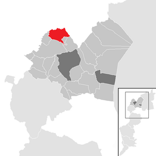
| Location of Leithaprodersdorf in the Eisenstadt-Umgebung district | ||
  |
||
 Roman Catholic parish church in the center of the village |
||
| Source: Municipal data from Statistics Austria | ||

Leithaprodersdorf ( Croatian Mađarski Proderštof , Hungarian Lajtapordány ) is a municipality with 1208 inhabitants (as of January 1, 2020) in Burgenland in the Eisenstadt-Umgebung district in Austria . The community lies on the Lower Austrian border, where the sister town Deutsch Brodersdorf adjoins (see picture location of the bath house ).
geography
The municipality is located in northern Burgenland on the border with Lower Austria near the state capital Eisenstadt.
Community structure
Leithaprodersdorf is the only cadastral municipality and the only locality ( village ) in the municipality.
Neighboring communities
| Weigelsdorf |
Seibersdorf (Gem., District Baden , Lower Austria )
German Brodersdorf (Gem. Seibersdorf, Lower Austria) |
|
| Pottendorf (Gem., District Baden , Lower Austria ) |
.svg)
|
Au am Leithaberge (Gem., District Bruck adL , Lower Austria ) |
|
Wampersdorf (Gem. Pottendorf, Lower Austria)
Wimpassing on the Leitha (Gem.)
|
Chert (gem.) |
Loretto (Gem.)
|
- ∗ The place Stotzing is behind Loretto, the municipality between this and Au shortly adjacent
history
Before the birth of Christ, the area was part of the Celtic Kingdom of Noricum and belonged to the surroundings of the Celtic hill settlement Burg on the Schwarzenbacher Burgberg .
Later under the Romans, today's Leithaprodersdorf was then in the province of Pannonia . Older finds prove activities at that time. In Roman times, the municipality of Leithaprodersdorf was densely populated. Two large manors and a watchtower ( Burgus ) as well as the associated grave fields with gravestones have been named after excavations since the previous century. The names Maguricius, Ussuro, Ucco, Cenomarus, Gnatila as well as Octo, Aurelia Valla and Aurelia Florentina attest to the Celtic-Roman mixed population of the 1st to 3rd centuries. From the early history of a burial place originates Avars from the 8th century when Anne Cross.
The most important ground monument on the outskirts of Leithaprodersdorf that is still visible today is the G'schlößl , a medieval moated castle consisting of three concentric ditches and ramparts. It was built in the 13th century on the ruins of the Roman watchtower to secure the Leitha crossing. The castle was first mentioned in a document in 1232.
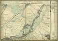
around 1873: still "Ungarisch Prodersdorf" (bottom left, recording sheet of the regional survey )

The municipality in the south of 1873, the moat of the moated castle can still be seen with a water channel (top left)


The bathing establishment in Leitha-Prodersdorf appeared in the press as early as the 1860s . Even decades after 1900, Bad Prodersdorf (sometimes: Bad Brodersdorf ) was known as a place name. It referred to the springs at today's address Badgasse 49, which were developed as therapeutic and thermal baths and were up to 26 degrees Celsius. The baths, for which the Ebreichsdorf , Weigelsdorf and Unterwaltersdorf stations were named for indirect rail access , was popular as a day trip destination, among other things at Viennese cycling clubs.
The place belonged like the whole of Burgenland to the Kingdom of Hungary ( German-West Hungary ) until 1920/21 , was called Hungarian Prodersdorf , and was an important border crossing to Deutsch Brodersdorf in the Archduchy of Austria and Crown Land Austria under the Enns . Since 1898 had due to the Magyarization of the government in Budapest of Hungarian name Lajtapordány be used. After the end of the First World War , after tough negotiations, German-West Hungary was awarded to Austria in the Treaties of St. Germain and Trianon in 1919. The place has belonged to the newly founded federal state of Burgenland since 1921 (see also the history of Burgenland ).
In 1982 the community celebrated 750 years of its existence, combined with the elevation to the market.
On January 1, 1990, the cadastral communities or localities Loretto and Stotzing , which had previously belonged to the market town of Leithaprodersdorf, were separated, and Leithaprodersdorf was created as a new community.
Today Leithaprodersdorf and Deutsch Brodersdorf have grown together completely into one settlement unit .
Research has shown that Leithaprodersdorf can be described as the oldest named place in Burgenland. The name comes from Lithaha with the preposition super Sconibrunno , in German above the beautiful fountain from the year 833.
.svg)
Population development

Culture and sights

Landmark of the community: the listed mountain church

War memorial in Leithaprodersdorf

The "Gschlössl" wall-ditch system of the former weir system


- Catholic parish church Leithaprodersdorf : The church is a new building from 1680 on the site of a former chapel. In the course of the Turkish wars in 1683, the church was sacked and renovated in 1696.
- To the east of the village are the remains of a medieval fortification with its wall and ditch system that is still visible today. The Gschlößl is a moated castle consisting of three concentric trenches and ramparts.
- The former medieval parish church of St. Stephan Martyr was built southwest of the village on the "mountain" and is now called Pfefferbüchsel ; In 1252 it served as a place of refuge when the Hungarians invaded. However, in 1683 it was destroyed, restored in 1907 and converted into a chapel ( Trinity Chapel ). In 1972 an exterior renovation took place. In 1975 Gothic fresco remains were found in the tower chapel.
politics
Municipal council
The council comprises a total of 19 members on the basis of the electorate.
| Political party | 2017 | 2012 | 2007 | 2002 | 1997 | ||||||||||
|---|---|---|---|---|---|---|---|---|---|---|---|---|---|---|---|
| Sti. | % | M. | Sti. | % | M. | Sti. | % | M. | Sti. | % | M. | Sti. | % | M. | |
| ÖVP | 638 | 76.77 | 15th | 604 | 71.65 | 14th | 578 | 73.07 | 11 | 556 | 71.01 | 11 | 531 | 81.44 | 13 |
| SPÖ | 121 | 14.56 | 3 | 176 | 20.88 | 4th | 213 | 26.93 | 4th | 227 | 28.99 | 4th | 121 | 18.56 | 2 |
| LPL A1 | 72 | 8.66 | 1 | 63 | 7.47 | 1 | not running | not running | not running | ||||||
| Eligible voters | 1021 | 1005 | 950 | 911 | 839 | ||||||||||
| voter turnout | 86.09% | 87.66% | 89.47% | 91.44% | 86.65% | ||||||||||
Parish council
In addition to Mayor Martin Radatz (ÖVP) and Deputy Mayor Horst Blümel (ÖVP), the executive councils Josef Eder (ÖVP), Georg Menitz (ÖVP) and Birgit Ulrichshofer (ÖVP) also belong to the community board.
Georg Menitz (ÖVP) was also elected to the municipal treasurer and Josef Eder (ÖVP) to the environmental council at the constituent meeting of the municipal council.
mayor
Mayor is Martin Radatz (ÖVP), who succeeded Matthias Heinschink (ÖVP) in 2007. In the 2017 direct mayor election, Radatz was confirmed in office with 73.13%. His two competitors Karl Matthias Posch (SPÖ) and Josef Paul Trapichler (List Paul) did not exceed 15.93% and 10.94% respectively. At the constituent meeting of the municipal council, Horst Blümel (ÖVP) was elected Vice Mayor.
Michael Bauer is the head of the office.
Personalities
- Gabriele Arenberger (* 1960), politician
literature
- Alexander Seracsin (find report), Herbert Mitscha-Märheim ( edit .): The Avar cemetery of Leithaprodersdorf . Burgenland State Museum, Eisenstadt 1957, OBV .
- 750 years of Leithaprodersdorf 1232–1982. Festschrift on the occasion of the 750th anniversary and the elevation to the market town on August 21-29, 1982 . Market community Leithaprodersdorf, Leithaprodersdorf 1982, OBV .
- Sonja-Ulrike Prochaska: On the medieval moated castle of Leithaprodersdorf ( political district Eisenstadt , Burgenland) and a contribution to the reuse / further use of Roman buildings in the Middle Ages . Thesis. University of Vienna, Vienna 1994, OBV .
- Martin Siffert: Field name book Leithaprodersdorf. Original of the Leithaprodersdorfer field names book . Deviating title: The Leithaprodersdorfer field names in their historical, geographical and linguistic context . Leithaprodersdorf municipality, Leithaprodersdorf 2008, OBV .
- Bundesdenkmalamt , Franz Sauer , Nikolaus Hofer, Marita Holzner (contributions): Leithaprodersdorf from the Early Bronze Age to the Middle Ages . Berger, Horn 2011, OBV .
- Hannah Lzicar: The grave field Leithaprodersdorf, Burgenland . Master thesis. University of Vienna, Vienna 2013, OBV . - Full text online (PDF; 21 MB) .
Web links
- Community website
- Entry on Leithaprodersdorf in the Austria Forum (in the AEIOU Austria Lexicon )
- 10306 - Leithaprodersdorf. Community data, Statistics Austria .
- Aerial photos of Leithaprodersdorf
Individual evidence
- ^ Karl Ulbrich: The "Gschlößl" from Leithaprodersdorf. In: Burgenland homeland sheets . No. 19/1957, Eisenstadt 1957, OBV , pp. 104–112, PDF on ZOBODAT
- ↑ Lease of the bathing establishment in Leitha-Prodersdorf. In: Wiener Zeitung , No. 207/1866, August 22, 1866, p. 494, bottom right. (Online at ANNO ). .
- ↑ A healing spring developed by the old large farmer of the "Röthelstoaner". In: Grazer Volksblatt , evening edition, No. 56/1911 (XLIV. Year), February 4, 1911, p. 3 middle. (Online at ANNO ). .
- ↑ To the barn. The location . In: Arabelle Kamler (Red.): Zurscheune.at , accessed on November 8, 2017.
-
↑ Notes. (...) "The Wanderer". In: Allgemeine Sport-Zeitung , year 1883, July 26, 1883, No. 39/1883 (fourth year), p. 633, top center. (Online at ANNO ). ;
General sports news. (...) cycling. (...) Community excursions. (...) Viennese cycling club "Wanderlust". In: Deutsches Volksblatt / Deutsches Volksblatt. Radical medium-sized organ / telegraph. Radical Mittelstandsorgan / Deutsches Volksblatt. Daily newspaper for Christian German politics , morning edition, No. 3397/1898 (Xth year), June 18, 1898, p. 12 (unpaginated), column 2. (Online at ANNO ). . - ↑ 750 years Leithaprodersdorf 1232-1982 .
- ↑ 53. Ordinance of the Burgenland regional government of October 18, 1989 on the separation of the market town of Leithaprodersdorf. In: Landesgesetzblatt für das Burgenland , year 1989, LGBl 1989/53, p. 267. (Online at ANNO ). .
- ↑ Leithaprodersdorf: Officially the oldest place on ORF Burgenland from September 26, 2016, accessed on September 26, 2016
- ↑ RIS - Announcement on the republication of the Burgenland municipal code - Consolidated provincial law Burgenland, version of 24.07.2018. Retrieved July 24, 2018 .
- ↑ a b Province of Burgenland: Election results Leithaprodersdorf 2017 (accessed on December 13, 2017)
- ↑ Province of Burgenland: Election results Leithaprodersdorf 2012 (accessed on December 13, 2017)
- ↑ Province of Burgenland: election results Leithaprodersdorf 2007 (accessed on December 13, 2017)
- ↑ a b Province of Burgenland: election results Leithaprodersdorf 2002 (accessed on December 13, 2017)
- ↑ a b c Marktgemeinde Leithaprodersdorf: Municipal Councils (accessed on December 13, 2017)
- ↑ Marktgemeinde Leithaprodersdorf: The team in the municipal office (accessed on December 13, 2017)
Breitenbrunn am Neusiedler See | Donnerskirchen | Großhöflein | Chert | Klingenbach | Leithaprodersdorf | Loretto | Mörbisch am See | Müllendorf | Neufeld an der Leitha | Oggau am Neusiedler See | Oslip | Purbach am Neusiedler See | Sankt Margarethen im Burgenland | Protecting the mountains | Siegendorf | Steinbrunn | Stotzing | Trausdorf an der Wulka | Wimpassing on the Leitha | Wulkaprodersdorf | Zagersdorf | Zillingtal
Cadastral municipality and locality: Leithaprodersdorf
Village: Leithaprodersdorf | Other locations: Dreifaltigkeitskapelle
Counting district: Leithaprodersdorf