List of moors in the Harz Mountains

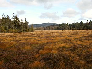
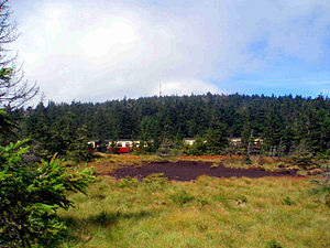
The list of moors in the Harz contains a selection of moors in the Harz , a low mountain range and a natural spatial main unit (No. D37) in the German states of Lower Saxony , Saxony-Anhalt and those in the Harz National Park and in the Harz (Lower Saxony) nature parks , Harz / Saxony-Anhalt .
Moors
Some columns of the table sorted by height in meters (m) above sea level in the initial view can be sorted by clicking on the symbols next to their headings , unless otherwise specified according to BfN . In the “Moor” column, alternative names are put in brackets, in small print and in italics .
The abbreviations used in the table below illustrates.
| Moor (geographic coordinates) |
Height (m) |
Area ㎡ |
Harz part / Harz foreland part; NLP , NRP |
Location localities (at / between) |
GG ; Agricultural circle / e ( s. U. ) |
Country / Countries ( see below ) |
Location of (location in / at: BPR , NSG ; sights; waters / sources) |
image |
|---|---|---|---|---|---|---|---|---|
|
Auf-dem-Acker-Moor ( ⊙ ) |
NLP resin | NI | On the field | |||||
|
Flowerpot bog ( ⊙ ) |
16ha | NLP resin | Three Anne Hohne | ST | Small holtemme | |||
|
Bodebruch Bodemoor ( ⊙ ) |
112.270㎡ | NLP resin | Oderbrück | GG-GS | NI | Gloomy fir trees Q: Warm soil |
||
|
Brockenbett Brockenbettmoor ( ⊙ ) |
NLP resin | ST |
Brockenstrasse Q: Ilse |
|||||
|
Brockenfeld ( ⊙ ) |
529.200㎡ | NLP resin |
Torfhaus Oderbrück |
GG-GS | NI | Goetheweg | ||
| Brockenkuppe | NLP resin | Chunks | ||||||
|
Bruchbergmoor ( ⊙ ) |
748.920㎡ | NLP resin |
Altenau Sonnenberg |
GG-GS | NI |
Bruchberg B 242 |
||
|
Eckersprungmoor ( ⊙ ) |
NLP resin | ST |
Goetheweg Q: Ecker |
|||||
|
Flörichshaier Moor Flörichshaier Sattelmoor ( ⊙ ) |
NLP resin | GG-GS | NI | Abegraben Flörichshaier Graben Rotenbeek |
||||
|
Goethemoor ( ⊙ ) |
NLP resin | ST | Q: Königsbach Q: Black Schluftwasser |
|||||
|
Großes Torfhausmoor (Torfhausmoor, Radaubornmoor Radauer Born) ( ⊙ ) |
800m | 174.080㎡ | NLP resin | Peat house | GG-GS | NI | Abbe Abbegraben Goetheweg Q: Radau |

|
|
Heinrichshöhemoor ( ⊙ ) |
NLP resin | ST | Heinrichshöhenweg Brockenstrasse Brockenbahn (passing) , Brockenteich , Brockentor-Klippe Heinrichshöhe S: Ilse |
|||||
|
Hörstemoor (three-hearing break, hearing break ) ( ⊙ ) |
26,630㎡ | NLP resin | GG-GS | NI | Oderteich | |||
| Jakobsbruch drained at the beginning of the 19th century ( ⊙ ) |
NLP resin | Schierke | ST | Wormke | ||||
| Kaiserwegbruch | ||||||||
| Small peat house bog | 800m | 7,967㎡ | NLP resin | Peat house | GG-GS | NI | ||
|
Königsbruch (Harz) ( ⊙ ) |
18,780㎡ | NLP resin | King jug | GG-GS | NI | |||
|
Long fraction ( ⊙ ) |
158.740㎡ | NSG BR 081 | Braunlage | GS | NI | |||
|
Magdbettmoor ( ⊙ ) |
94.120㎡ | NLP resin | Peat house | GG-GS | NI | |||
|
Marienbruch ( ⊙ ) |
114,990㎡ | NLP resin |
Bad Harzburg peat house |
GG-GS | NI | |||
|
Mooksbruch ( ⊙ ) |
NLP resin | Schierke | ST | Strawberry head | ||||
|
Upper Black Moor and possibly Upper Black Marsh |
||||||||
|
Oderbruch ( ⊙ ) |
171.430㎡ | NLP resin | Oderbrück | GG-GS | NI | Q: Or | ||
|
Oderbrückmoor ( ⊙ ) |
NLP resin | Oderbrück | NI | |||||
|
Raven Cliff Bog ( ⊙ ) |
NLP resin | ST | Rabenklippe Kesselklippe |
|||||
|
Rehbachmoor ( ⊙ ) |
58.92㎡ | NLP resin | GG-GS | NI | Q: Rehbach | |||
|
Rehberger Gipfelmoor ( ⊙ ) |
NLP resin | Sankt Andreasberg | GG-GS | NI | Rehberg | |||
| Rehbergmoor | NLP resin | GG-GS | NI | |||||
|
Riefenbruch ( ⊙ ) |
54,490㎡ | NLP resin | Bad Harzburg | GG-GS | NI | |||
|
Red fraction (small red fraction, large red fraction) ( ⊙ ) |
161,490㎡ | NLP resin |
Oderbrück Königkrug |
GG-GS | NI | |||
| Sandbeekmoor | ||||||||
| Schalkemoor | ||||||||
|
Black swamp ( ⊙ ) |
72,890㎡ | NLP resin |
Oderbrück Königkrug |
GG-GS | NI | |||
| Seigerhüttenteich | 14,670㎡ | Wernigerode | ST | |||||
|
Sonnenberger Moor ( ⊙ ) |
494.050㎡ | NLP resin | Sonnenberg | GG-GS | NI | B 242 | ||
|
Goldfinch Moor ( ⊙ ) |
NLP resin | GG-GÖ GG-GS |
NI | |||||
|
Lower Black Moor, possibly Lower Black Swamp |
||||||||
| Wurmbergmoor | NSG BR 140 | Braunlage | GS | NI |
- Rotenbeek Tal = or! = Red Moor, rear and middle
Abbreviations
The abbreviations used in the table (sorted alphabetically) mean:
Counties ( license plate ):
- GS = District of Goslar (Lower Saxony)
- HZ = District of Harz (Saxony-Anhalt)
Unregulated areas (GG):
Countries (federal states; ISO 3166-2 ):
- NI = Lower Saxony
- ST = Saxony-Anhalt
- NLP Harz = Harz National Park
- NRP Harz (NI) = Harz Nature Park (Lower Saxony)
- NRP Harz / ST = Harz / Saxony-Anhalt Nature Park
- NRP Südharz = Southern Harz Nature Park
- NSG BR 081 = stream valleys in the Upper Harz around Braunlage
- NSG BR 140 = Wurmberg
Others:
- AP = viewing platform / viewing point
- AT = lookout tower
- B = federal road
- BPR = biosphere reserve
- GG = community-free area
- L = state road
- Q = source
See also
Individual evidence
- ↑ a b Map services of the Federal Agency for Nature Conservation ( information )
- ↑ Auf-dem-Acker-Moor (Q28753972)
- ↑ Auf-dem-Acker-Moor in OpenStreetMap
- ↑ Ground break (Q28464599)
- ↑ http://www.harzlife.de/special/bodebruch.html
- ↑ Bodebruch in OpenStreetMap
- ↑ Brocken bed (Q28466366)
- ↑ Brockenbettmoor in OpenStreetMap
- ↑ Brockenfeld (Q28464626)
- ↑ Brockenfeld in OpenStreetMap
- ↑ Bruchbergmoor (Q28464634)
- ^ Bruchbergmoor in OpenStreetMap
- ↑ Ecker jump peat (Q28753757)
- ↑ Eckersprungmoor in OpenStreetMap
- ↑ Flörichshaier Moor (Q28845860)
- ↑ Flörichshaier Moor in OpenStreetMap
- ↑ Goethemoor (Q28709468)
- ^ Goethemoor in OpenStreetMap
- ↑ Large peat house moor (Q14537413)
- ↑ Large peat house moor in OpenStreetMap
- ↑ Heinrichshöhemoor (Q28753723)
- ^ Heinrichshöhemoor in OpenStreetMap
- ↑ Hörstemoor (Q28464646)
- ↑ Hörstemoor in OpenStreetMap
- ↑ Jakobsbruch (Q28845886)
- ↑ a b Around the Erdbeerkopf - flint cliffs, hiking trails
- ↑ Jakobsbruch in OpenStreetMap
- ↑ Small peat house moor (Q28464584)
- ↑ Small peat house moor in OpenStreetMap
- ↑ Königsbruch (Q28464662)
- ↑ Königsbruch in OpenStreetMap
- ↑ Long fraction (Q28464664)
- ↑ Long break in OpenStreetMap
- ↑ Magdbettmoor (Q28464624)
- ↑ Magdbettmoor in OpenStreetMap
- ↑ Marienbruch (Q28464629)
- ^ Marienbruch in OpenStreetMap
- ↑ Mooksbruch (Q28845896)
- ↑ Mooksbruch in OpenStreetMap
- ↑ Oderbruch (Q28464594)
- ↑ Oderbruch in OpenStreetMap
- ↑ Oderbrückmoor (Q28753840)
- ↑ Oderbrückmoor in OpenStreetMap
- ↑ Rabe clip Moor (Q28753934)
- ↑ Raven Cliff Moor in OpenStreetMap
- ↑ Rehbachmoor (Q28530503)
- ↑ Rehbachmoor in OpenStreetMap
- ↑ Rehbach (Q28753876)
- ↑ Rehberger Gipfelmoor (Q28845991)
- ↑ Riefenbruch (Q28464628)
- ↑ Riefenbruch in OpenStreetMap
- ↑ Red fraction (Q28464658)
- ↑ Red fraction in OpenStreetMap
- ↑ Black Swamp (Q28464652)
- ↑ Schwarzer Sumpf 1 , 2 in OpenStreetMap
- ↑ Seigerhüttenteich in OpenStreetMap
- ↑ Sonnenberger Moor (Q28464641)
- ^ Sonnenberger Moor in OpenStreetMap
- ↑ Goldfinch Moor (Q28846030)
- ↑ Stieglitzmoor in OpenStreetMap
