Mittelrode (Fulda)
|
Mittelrode
City of Fulda
Coordinates: 50 ° 32 ′ 23 ″ N , 9 ° 36 ′ 19 ″ E
|
|
|---|---|
| Height : | 299 m above sea level NHN |
| Area : | 1.78 km² |
| Residents : | 355 (Dec. 31, 2015) |
| Population density : | 199 inhabitants / km² |
| Incorporation : | August 1, 1972 |
| Postal code : | 36041 |
| Area code : | 0661 |
|
Mittelrode
|
|
Mittelrode is a district of the East Hessian city of Fulda .
The district is located six kilometers west of the core city on the Saurode at the foot of the 416 m high Haimberg . The state road 3139 leads through the village.
history
It was first mentioned in 1116 when the village was first mentioned in a document.
A special cemetery is mentioned in the historical local dictionary for Mittelrode from the 15th to 17th centuries. There were probably special burials in Mittelroda .
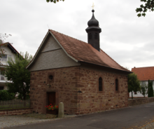
The chapel , which was built in 1720 under the Haimbach pastor Johann Adam Breun (1716–1723) during the residence of the Fulda prince abbot Konstantin von Buttlar , is dedicated to St. Joseph and is still used today as a branch church.
In 1787 it belonged to the abbey of Fulda . Parish affiliation: It was assigned to the parish of Haimbach .
1790 it was a village of Schultheißerei Sickels of centering Office Fulda .
In 1834 158 people lived in Mittelrode.
Reorganization
On August 1, 1972, the previously independent municipality of Mittelrode was incorporated into the city of Fulda by means of state law as part of the regional reform in Hesse .
Population development
Source: Historical local dictionary
| • 1812: | 17 fireplaces, 92 souls |
| Mittelrode: Population from 1812 to 2015 | ||||
|---|---|---|---|---|
| year | Residents | |||
| 1812 | 92 | |||
| 1834 | 158 | |||
| 1840 | 162 | |||
| 1846 | 158 | |||
| 1852 | 158 | |||
| 1858 | 164 | |||
| 1864 | 144 | |||
| 1871 | 121 | |||
| 1875 | 121 | |||
| 1885 | 129 | |||
| 1895 | 144 | |||
| 1905 | 117 | |||
| 1910 | 118 | |||
| 1925 | 135 | |||
| 1939 | 140 | |||
| 1946 | 184 | |||
| 1950 | 199 | |||
| 1956 | 188 | |||
| 1961 | 191 | |||
| 1967 | 201 | |||
| 1970 | 208 | |||
| 1988 | 280 | |||
| 2010 | 339 | |||
| 2013 | 347 | |||
| 2015 | 355 | |||
| Data source: Historical municipality register for Hesse: The population of the municipalities from 1834 to 1967. Wiesbaden: Hessisches Statistisches Landesamt, 1968. Further sources:; 2010,2012,2015: | ||||
Religious affiliation
In 1787 the place belonged to the prince abbey of Fulda , Centoberamt Fulda Source: Historisches Ortslexikon
| • 1885: | no Protestant, 129 Catholic (= 100.00%) residents |
| • 1961: | one Protestant (= 0.52%), 190 Catholic (= 99.48%) inhabitant |
Catholic parish in Haimbach
useful information
At the foothills of the 416 m high Haimberg, between Mittelrode and Haimbach, there is a memorial stone erected in 1950: "Law must remain law, including the right to a home". It was built by the 1st Egerländer Gmoi Haimbach and the surrounding area.
In 1981 the Fulda district association of the Association of Expellees erected another monument in the immediate vicinity in the form of a 10 m high steele.
The monument can be reached via the streets "Schwalbengasse" and "Lärenstieg" on the heights of the eastern foothills of the Haimberg .
Infrastructure
The Fulda-Nord motorway junction of the A7 can be reached eastwards via the Weimarer Strasse tunnel and federal road 27 .
literature
- Literature about Mittelrode in the Hessian Bibliography
- Search for Mittelrode (Fulda) in the archive portal D of the German Digital Library
Web links
- Mittelrode district on the website of the city of Fulda.
- Mittelrode, district of Fulda. Historical local dictionary for Hessen. In: Landesgeschichtliches Informationssystem Hessen (LAGIS).
Individual evidence
- ↑ Areas of the city districts. (PDF; 30 KB) In: Internet presence. City of Fulda, archived from the original ; accessed in May 2018 .
- ↑ Population of the city districts. (PDF; 17 KB) In: Internet presence. City of Fulda, archived from the original ; accessed in May 2018 .
- ↑ Law on the reorganization of the districts of Fulda and Hünfeld and the city of Fulda (GVBl. II 330-14) of July 11, 1972 . In: The Hessian Minister of the Interior (ed.): Law and Ordinance Gazette for the State of Hesse . 1972 No. 17 , p. 220 , § 1 ( online at the information system of the Hessian state parliament [PDF; 1,2 MB ]).
- ^ Federal Statistical Office (ed.): Historical municipality directory for the Federal Republic of Germany. Name, border and key number changes in municipalities, counties and administrative districts from May 27, 1970 to December 31, 1982 . W. Kohlhammer GmbH, Stuttgart / Mainz 1983, ISBN 3-17-003263-1 , p. 387 .
- ↑ a b c Mittelrode, district of Fulda. Historical local dictionary for Hessen. (As of May 24, 2018). In: Landesgeschichtliches Informationssystem Hessen (LAGIS).
- ↑ Statistical Report 2011. (PDF; 11 KB) City of Fulda, p. 9 , archived from the original ; accessed in May 2018 .
- ↑ The population density in the statistical districts of the city of Fulda (as of December 31, 2013). (PDF; 11 KB) Archived from the original ; accessed in May 2018 .
- ↑ The population density in the statistical districts of the city of Fulda (as of December 31, 2015). (PDF; 11 KB) Archived from the original ; accessed in May 2018 .


