Municipio Camargo (Chihuahua)
| Camargo | ||
|---|---|---|

|
||
| Symbols | ||
|
||
| Basic data | ||
| Country | Mexico | |
| State | Chihuahua | |
| Seat | Santa Rosalía de Camargo | |
| surface | 13,767.9 km² | |
| Residents | 48,748 (2010) | |
| density | 3.54 inhabitants per km² | |
| founding | 1820 | |
| INEGI no. | 08011 | |
| politics | ||
| Presidente municipal | Arturo Zubia Fernández | |
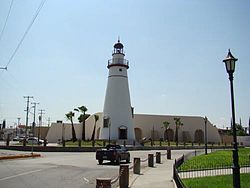
| The Faro de las Estrellas in Santa Rosalía de Camargo | ||
Coordinates: 28 ° 0 ′ N , 104 ° 24 ′ W
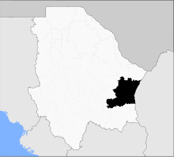
Camargo is a municipality with almost 50,000 inhabitants in the Mexican state of Chihuahua . The municipality has an area of 13,767.9 km². The administrative seat and largest town of the municipality is Santa Rosalía de Camargo .
geography
The municipality of Camargo is located in the east of the state of Chihuahua at an altitude between 1200 m and 2400 m . It belongs entirely to the physiographic province of Sierras y Llanuras del Norte and is 87% in the endorheic basin of the Bolsón de Mapimí , 13% of the municipal area belongs to the hydrological region Bravo - Conchos and drains into the Gulf of Mexico . The geology of the municipality is determined by 56% alluvion with 16% rhyolite tuff , 15% basalt and 7% conglomerate rock ; The predominant soil types in the municipality are Calcisol (47%), Leptosol (25%), Vertisol (6.5%) and Luvisol (6%). Over 62% of the community area is covered by brushwood, 34% is taken up by pastureland.
The municipality is surrounded by the municipalities Julimes , Ojinaga , Manuel Benavides , Jiménez , Allende , San Francisco de Conchos , La Cruz and Saucillo and also borders the state of Coahuila .
population
In the 2010 census, 48,748 people in 13,516 residential units were counted in the municipality. Of these, 654 people were registered as speakers of an indigenous language , including 450 speakers of the Tarahumara language . A good three percent of the population was illiterate. 19,292 inhabitants were registered as economically active, of which almost 70% were men and 5.7% were unemployed. 4% of the population lived in extreme poverty.
places
The Municipio Camargo comprises 305 inhabited localidades , of which only the main town is classified as urban by the INEGI . In the 2010 census, 22 towns had a population of over 100. The biggest places are:
| place | Residents |
| Santa Rosalía de Camargo | 40.221 |
| Alta Vista | 971 |
| La Perla | 943 |
| El Tecuán | 597 |
| San Ignacio | 567 |
Web links
- Enciclopedia de los Municipios y Delegaciones de México: Municipio Camargo (Spanish)
- INEGI : Datos Geográficos: Municipio Camargo (Spanish; PDF)


