
Dagestan Oblast
The Dagestan Oblast was an administrative-territorial unit in the Russian Empire that had emerged over many centuries. The administrative center was located in the city of Buinaksk ( Russian: Буйна́кск ) (Шура / Темирхан-Шура; Shura / Temirchan-Shura).

With the establishment of the USSR in 1918, all previous administrative structures were dissolved and the Dagestani Autonomous Soviet Socialist Republic emerged from the Oblast together with the Terek Oblast in 1921 . After the breakup of the USSR, the region remained in the Russian republic and has been the Autonomous Republic of Dagestan since 1992 .
geography
Location and limits
The Dagestan Oblast ( oblast = region ) comprised the northeastern part of the Caucasus - isthmus north of the main Caucasus with the Sulak – Terek watershed over the so-called Andean ridge . The course of the Sulak river to the Agrachansk Bay formed the northern border of the region. This was followed by the Terek Oblast, in which the Sulak flows into the Terek River. The eastern border of the oblast was the coast of the Caspian Sea between the Agrachansk Peninsula ( Аграханский Полуостров ) (Uch Spit) and the mouth of the Samur in the sea. The governorates of Tbilisi and Baku joined to the south .
surface
The region is very mountainous , only a narrow strip on the coast of the Caspian Sea (around 2000 km²) is flat. This is covered with sand, salt marshes and black earth. And only on this fertile soil could some agriculture be done.
Natural resources
In the mountains, geologists found sulfur , rock salt , coal , ores with cinnabar, lead and other metals. These mineral resources were mined and mostly developed for personal use. In addition, there were and still are mineral springs near the city of Petrovsk , which are used for both drinking and medicinal purposes.
climate
The climate of Dagestan Oblast was and is continental, hot in the valleys and rough in the mountains. Precipitation is low; Vegetation is poor, forests are scarce. The Caspian coast is humid and hot, with lush vegetation and lots of forests.
economy
overview
Little industry developed in the region. This dealt mainly with the processing of the metals extracted from the ores , armourers emerged and jewelry production played a role ( silver , also known as Caucasian black for corresponding products). Mining took place almost exclusively for local needs, while sulfur - especially in the Andi area - was mined and exported in large quantities. It was reported that around 35 tonnes were extracted annually . From animal products such as wool and skins which originated Leather and - textile industry (carpets, towels, burqas). Because trade in goods played only a minor role, the inhabitants of Dagestan Oblast were dependent on imports .
Agriculture
Due to the lack of large areas for growing grain - some of the few even had to be artificially irrigated - the harvest was insufficient to meet the needs of the residents. Grain or finished products from them had to be imported. Winter wheat was cultivated in the lowlands and spring cereals in the mountains.
The livestock was relatively sophisticated: 1812000 For the 1904 sheep , 225,000 goats , 43,000 horses and 40,000 domestic donkey and mules documented. In lower areas, wine was grown on southern slopes as well as fruit and vegetables for personal use.
Administration and population

Head of the region
Because the oblast was primarily of military importance to protect the tsarist empire against invading conquerors, a military government was established here. In the years 1859-1880 Levan Ivanovich Melikow (Prince, Lieutenant General ) headed the oblast.
Military governors
The following governors were appointed in the 50 years before the oblast was abolished, but their administrative areas were not identical to the districts:
- Nikolai Zurabowitsch Chavchavadze: January 10, 1880–9. March 1896 (Prince, Lieutenant General)
- Alexander Anatoljewitsch Baryatinsky: April 10, 1896-9. October 1901 (Prince, Lieutenant General)
- Evgraf Filippowitsch Tichanow: November 16, 1901–1907 (Lieutenant General)
- Vladimir Alexejewitsch Alftan: 1907–1908 ( Major General )
- Sigismund Wiktorowitsch Wolski: June 24, 1908–17. March 1915 (Major General)
- Georgi Tengisowitsch Dadeschkeliani : April 1915-28. December 1916 (Major General)
- Vladimir Viktorovich Ermolow (also written Yermolow): December 28, 1916 – April 1917 (Lieutenant General)
Organs of the military governor
At the side of the governors were:
- Evgraf Filippowitsch Tichanow: July 24, 1884-19. October 1890
- Artemi Semjonowitsch Usbaschew: from 1891
Administrative areas with areas and inhabitants

From the region of Dagestan, which was still divided into eleven sub-areas in the 19th century, the following nine districts emerged by the end of the 19th century :
- Awarsk ( Аварский ), district center Chunsach (1,587 inhabitants), area: 1,323.9 QW ;
Total inhabitants: 37,639 - Andisk ( Андийский ), district center Botlich (1.225 Ew.); Area: 3,152.6 QW;
Total population: 49 628 - Gunibsk ( Гунибский ), district center Gunib (685 inhabitants), area: 3,873.1 QW;
Total inhabitants: 55,899 - Dargin ( Даргинский ), district center Levaschi (1,343 inhabitants), area: 1,451.7 QW;
Total inhabitants: 80,943 - Kazikumuchsk ( Казикумухский ), district center Kumuch (621 Ew.) Area: 1,977.6 QW; Total population: 363
- Kaitago-Tabasaransk ( Кайтаго-Табасаранский ), district center Majalis (1,327 inhabitants), area: 2,924.8 QW;
Total inhabitants: 91,021 - Kjurinsk ( Кюринский ), district center Kasum-Kent (1,013 Ew.), Area: 2603.9 QW;
Total inhabitants: 77,680 - Samursk (Самурский) , district center Akhty (3.190 Ew.), Surface area: 3274.1 QW;
Total inhabitants: 35,633 - Temir-Khan-Shurinsk ( Темир-Хан-Шуринский ), (9.214 Ew.), Area: 5.550.7 QW;
Total Ew. with surrounding area: 97,348
- Ew = inhabitant
In 1886 the total area of Dagestan Oblast was 26,132.4 QW; the total population of the oblast was 571,154 people. Since the areas are given in square meters (QW), that is 29,738.671 square kilometers after conversion .
In addition, the districts were divided into 532 Wolosts , 1,214 further settlements and three larger cities were located in them.
This administrative division existed until the complete restructuring of the area in 1921. (see map at the top)
Population by ethnic group and district
After the census of 1897 571,200 people lived in the region. The following overview shows the percentage distribution by nationality and district:
| District | Awaen | Darginzi | Hill tribes 1 | Kumyks | A&T 2 | Russian Jews | Ukrainians | Poland | Iranians | Nogaier | Arabs | Chechens | Tati |
|---|---|---|---|---|---|---|---|---|---|---|---|---|---|
| central area | 27.8 | 21.3 | 16.6 | 13.4 | 9.0 | 5.6 | 2.3 | 1.3 | |||||
| Awarsk | 95.8 | 1.1 | 2.4 | ||||||||||
| Andisk | 98.0 | 1.4 | |||||||||||
| Gunibsk | 93.4 | 1.4 | 3.8 | ||||||||||
| Darginsk | 3.9 | 91.3 | 4.6 | ||||||||||
| Kasikumuchsk | 5.4 | 8.1 | 2.1 | 83.8 | |||||||||
| Kaitago-Tabasaransk | 36.5 | 19.4 | 1.1 | 31.8 | 2.5 | 4.5 | |||||||
| Kyurinsk | 76.3 | 17.6 | 1.7 | 3.2 | |||||||||
| Samursk | 95.3 | 1.4 | 1.1 | ||||||||||
| Temir-khan-Shurinsk | 15.6 | 10.0 | 51.1 | 1.3 | 9.9 | 2.9 | 1.8 | 1.1 | 1.7 | 2.0 |
- [ 1 ]: Tabasarans , aghul people , rutul people , Kryzi, Buduchis , Chinalugier , Laki
- [ 2 ]: Azerbaijanis and Tatars
The population has increased sharply in all Caucasus regions due to the steady immigration of Muslim refugees. Russians were underrepresented in this area.
Religions
Because in the course of history people from the most varied of faiths immigrated to the Caucasus, they usually also brought their religious views with them and continued to live accordingly on site. Thus arose gradually mosques , temples , Christian churches (Protestant, Catholic, Orthodox) synagogues .
The majority of the population were (and are) ethnic Muslims (Muslims), who make up almost 90 percent.
history
Between the pre-Christian times and the beginning of the 19th century
As part of the territory of Dagestan , the oblast experienced the same changing rulers as Dagestan as a whole. These range from the Persians , the Romans , the Sassanids , the Arabs and the Mongols to the Russians , who displaced the Persians in the 18th century.
From 1813 to 1921
Since 1813, the region with the centrally located city of Derbent belonged to the Russian Empire. In 1846 it became the province of Derbent , on May 30, 1860 it was named Oblast Dagestan (Dagestan region) Derbent was given the new name Temir-Chan-Shura in 1866.
With the establishment of the Soviet Union in 1918, the Dagestan Oblast initially retained its historically evolved structures. Then it was combined with other earlier oblasts in the Dagestani Autonomous Soviet Socialist Republic , and the city with a Khan in its name became Buinaksk. Dagestan Oblast disappeared from the official administrative structure.
Development of the Oblast coat of arms

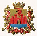
Blazon : A coat of arms with a gold-colored background shows part of a fortress with four towers and an open gate, in the lower part a blue area symbolizes the location of the region on the Caspisee. Between the higher towers there is a red crescent moon and a sideways turned lion head with an open mouth. The coat of arms is entwined with a wreath of golden oak leaves and bears the tsar's crown on top .
It was in force from 1880 to 1918 (1921). Tsar Alexander II wrote the description himself; the Russian Interior Ministry confirmed the use of the coat of arms in 1880.
The following coats of arms / emblems were (are) in use:
Official emblem as described above

Unofficial emblem of Dagestan Oblast, 1878; Ed. Sukachev

Emblem of the region in use since 2000


.png)
As the picture below shows, the restructured Republic of Dagestan with the now re-used coat of arms has adhered to the historical representation.
Personalities
Individuals who played a role in the conquest, development or domination of the oblast included:
- Mongol Timur Lenk
- Russian Field Marshal Ivan Paskevich
- Imam Shamil
- Sheikh ʿAbd ar-Rahmān as-Sughūrī (1792-1881)
- Lewan Melichow (also written Melikoff or Melikishvili in literature )
- Abū Muhammad al-Kikunī (1835–1913).
literature
- North Asia and the Caucasian Isthmus: With eight illuminated copper panels , Volume 4. 1806
- Edward Beliaev, Oksana Buranbaeva: Dagestan. Cultures of the World . Marshall Cavendish international, 2006.
- Uwe Halbach, Manarsha Isaeva: Dagestan: Russia's most difficult republic: political and religious development on the "Mountain of Languages" , Science and Politics Foundation, 2015.
- Frederik Koene: The Caucasus - An Introduction , Routledge, 2009.
- Three books (in Russian) about Dagestan Oblast in Библиотека Ц.С .: 78000 Дагестанская обл.
References and footnotes
- ↑ Details on the Agrachansk Bay on de.getamap.net; accessed on November 3, 2018.
- ↑ Russian Princess from Austria with details on the origin of the Melichow family: Who was Prince Maximilian Melikoff? ; accessed on November 6, 2018.
- ^ Daniel R. Brower, Edward J. Lazzerini: Russia's Orient: Imperial Borderlands and Peoples, 1700-1917 , Indiana University Press, 1997; Page 112: Levan Melichow was in this time [= 1865] the commander of Dagestan Oblast .
- ↑ North Asia and the Caucasian Isthmus: With eight illuminated copper panels, Volume 4