
Kumuch
Village
|
||||||||||||||||||||||||||||
|
||||||||||||||||||||||||||||
|
||||||||||||||||||||||||||||
.svg)

Kumuch ( Russian Кумух ; Lakish Лак officially Гъумук ) is a village (selo) in the Republic of Dagestan in Russia with 1,930 inhabitants (14 October 2010).
geography
The place is about 100 km as the crow flies south-southwest of the republic capital Makhachkala in the eastern part of the Greater Caucasus . It is located on the left bank of the Kasikumuchskoje Koisu , a right tributary of the Karakoisu .
Kumuch is the administrative center of Lakski Rajons and seat of the rural community (selskoje posselenije) Kumuchski selsowet. The place is almost entirely inhabited by sheets . The village also includes the villages of Diltschu and Ubra (1.5 km northwest). Diltschu is a good 110 km northeast on the territory of the Kumtorkalinski rajon , 15 km north of the center of Makhachkala on the coast of the Caspian Sea , and is inhabited by sheets from Kumuch.
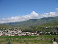
Kumuch

View over Kumuch to Djultydag ( 4127 m )
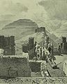
Fort of Kasi-Kumuch in the Caucasus War (1840s)
.jpg)
.jpg)

history
Tradition has it that the village in the center of the Lacian settlement area is identical to a Lak fortress in the principality of the same name and is therefore still referred to by the Laken as it is today. It was first mentioned in the 6th century as a place Kumuk in the far north of the Sassanid Empire . From the 13th century the place was called Gasi-Kumuk or Kasi-Kumuk, later in the Russian form as Kasi-Kumuch or Kasikumuch . During this time the place was the seat of the pubic bowl , from 1642 of the Khanate Kasi-Kumuch.
During the Caucasus War , Kasi-Kumuch was conquered by Russian troops in 1820 and the area was annexed to the Russian Empire . After the formation of Dagestan Oblast in 1860, the place became the administrative seat of Okrug Kasikumuch. After the formation of the Dagestani ASSR , the section was renamed the Lakic section (Lakski utschastok) in 1922 and converted into a canton of the same name in 1928; the administrative seat was always in Kumuch. On March 29, 1935, the canton was divided into the Lakski rajon, based in Kumuch, and the Kulinski rajon , later based in Watschi .
Population development
| year | Residents |
|---|---|
| 1897 | 621 |
| 1939 | 2386 |
| 1959 | 1981 |
| 1970 | 2088 |
| 1979 | 1869 |
| 1989 | 1965 |
| 2002 | 2483 |
| 2010 | 1930 |
Note: census data
traffic
The village is located on the regional road 82K-009, which branches off the federal highway R217 Kawkas (formerly M29, part of the European route 119 ) in Sovetskoye and continues from Kumuch in the central mountainous part of the republic via the district centers of Kassumkent , Chiw , Tpig and Watschi Gergebil runs. The 82N-007 branching off in Kumuch leads over the mountains to the neighboring Rajon center Gunib in the valley of the Karakoisu.
Web links
Individual evidence
- ↑ a b Itogi Vserossijskoj perepisi naselenija 2010 goda. Tom 1. Čislennostʹ i razmeščenie naselenija (Results of the All-Russian Census 2010. Volume 1. Number and distribution of the population). Tables 5 , pp. 12-209; 11 , pp. 312–979 (download from the website of the Federal Service for State Statistics of the Russian Federation)
| Cities |
Buinaksk S / R | Hasavyurt S / R | Dagestanskije Ogni S | Derbent S / R | Isberbash S | Yuzhno-Sukhokumsk S | Kaspiysk S | Kisiljurt S / R | Kisljar S / R | Makhachkala S. |
|
| Urban-type settlements |
Alburican | Achi-Su | Bawtugai | Beliji | Dubki | Kjachulai | Komsomolski | Leninkent | Mamedkala | Manas | Nowy Kjachulai | Nowy Sulak | Shamhal | Shamilkala | Semender | Sulak | Tarki | Tjube |
|
| Other Rajon centers |
Eighty | Agwali | Akusha | Babajurt | Beshta U | Botlich | Chebda | Chiw | Chunsach | Chuchni | Dylym | Gergebil | Gunib | Karabudachkent | Karata | Treasury | Kidero | Cork mask | Kumuch | Kurach | Levaschi | Majalis | Magaramkent | Mechelta | Nowokajakent | Novolakskoye | Rutul | Sergokala | Tarumowka | Terekli-Mekteb | Tljarata | Tpig | Unzukul | Urkarach | Uzukchai | Watschi | Zurib |