
Sergokala
Village
|
||||||||||||||||||||||||||||||
|
||||||||||||||||||||||||||||||
|
||||||||||||||||||||||||||||||
.svg)

Sergokala ( Russian Сергокала́ , Dargin Сергокъала ) is a village (selo) in the Republic of Dagestan in Russia with 8143 inhabitants (as of October 14, 2010).
geography
The place is about 60 km as the crow flies south-south-east of the republic capital Makhachkala in the north-eastern outskirts of the Greater Caucasus on the left bank of the river Kakaosen.
Sergokala is the administrative center of the Sergokalinski rajon as well as the seat of the rural community (selskoje posselenije) Sergokalinski selsowet, which also includes the village of Kadirkent, a good 6 km northwest. Today the village is practically mono-ethnic inhabited by Dargin people.

Commercial street in Sergokala

Street in Sergokala
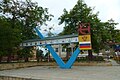
Stele with deserving citizens in the central square

Bust of the namesake Sergo Ordzhonikidze


history
The place was founded in 1846 during the Caucasus War as a Russian military settlement under the name Deschlagar , named after a nearby location, derived from the Dargin name of the woolly snowball growing there . On November 22, 1928, as part of the administrative restructuring of the Dagestani ASSR , the village was initially the seat of a canton and at the same time renamed Korkmaskala (alternative spelling Korkmas-Kala ), after the Kumyk publicist, politician and at that time head of government (chairman of the council of people's commissars ) Dagestan's Jelal-ed-Din Korkmassow (1877-1937); by order of July 3, 1929, the canton was converted into a Rajon. On September 10, 1937, Ort and Rajon were given their current names after the first name of the revolutionary and politician Sergo Ordzhonikidze ( Sergokala means something like Sergo City ), who died in the same year , while the previous namesake Korkmassow fell victim to the Stalinist repression .
Population development
| year | Residents |
|---|---|
| 1897 | 3016 |
| 1939 | 1813 |
| 1959 | 4026 |
| 1970 | 4661 |
| 1979 | 4825 |
| 1989 | 5591 |
| 2002 | 7627 |
| 2010 | 8143 |
Note: census data
traffic
Sergokala is the regional road 82K-011, which runs from Manas on the federal highway R217 via the neighboring district center of Karabudachkent to Pervomaiskoje near Isberbasch , also on the R217. The closest train station on the Rostov-on-Don - Makhachkala - Baku line is in the town of Isberbash, which is a good 20 km away . In Sergokala the regional road 82K-012 branches off in a westerly direction to the neighboring Levaschi Rajon center, which is further in the mountains .
Web links
Individual evidence
- ↑ a b Itogi Vserossijskoj perepisi naselenija 2010 goda. Tom 1. Čislennostʹ i razmeščenie naselenija (Results of the All-Russian Census 2010. Volume 1. Number and distribution of the population). Tables 5 , pp. 12-209; 11 , pp. 312–979 (download from the website of the Federal Service for State Statistics of the Russian Federation)
- ^ History of Sergokala on the Rajon Administration website
| Cities |
Buinaksk S / R | Hasavyurt S / R | Dagestanskije Ogni S | Derbent S / R | Isberbash S | Yuzhno-Sukhokumsk S | Kaspiysk S | Kisiljurt S / R | Kisljar S / R | Makhachkala S. |
|
| Urban-type settlements |
Alburican | Achi-Su | Bawtugai | Beliji | Dubki | Kjachulai | Komsomolski | Leninkent | Mamedkala | Manas | Nowy Kjachulai | Nowy Sulak | Shamhal | Shamilkala | Semender | Sulak | Tarki | Tjube |
|
| Other Rajon centers |
Eighty | Agwali | Akusha | Babajurt | Beshta U | Botlich | Chebda | Chiw | Chunsach | Chuchni | Dylym | Gergebil | Gunib | Karabudachkent | Karata | Treasury | Kidero | Cork mask | Kumuch | Kurach | Levaschi | Majalis | Magaramkent | Mechelta | Nowokajakent | Novolakskoye | Rutul | Sergokala | Tarumowka | Terekli-Mekteb | Tljarata | Tpig | Unzukul | Urkarach | Uzukchai | Watschi | Zurib |