
Cash
Village
|
||||||||||||||||||||||||||||||||||
|
||||||||||||||||||||||||||||||||||
|
||||||||||||||||||||||||||||||||||
| List of large settlements in Russia | ||||||||||||||||||||||||||||||||||
.svg)

Kasumkent ( Russian Касумкент even Kasumkent ; Lezgian Кьасумхуьр , Kasumchür ) is a village ( Aul , officially Selo ) in Dagestan with 13,232 inhabitants (14 October 2010) mainly lesgischer nationality.
geography
Kassumkent is located in the south of Dagestan, about 150 km as the crow flies from the capital of the republic, Makhachkala and about 45 km from Derbent between the rivers Tschirag-Tschai and Kurach at an altitude of about 480 m . The village is the administrative center of the Rajons Suleiman Stalski .
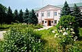
Treasury administration building
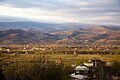
Panorama of Kassumkent


history
The village is said to have been founded several hundred years ago by a mountain dweller named Kassum (Kasum) who built his house in the wooded area on the Tschirag-Tschai. Over time, more residents from the surrounding areas settled. According to a census in 1886, there were 116 houses and 623 inhabitants (316 men and 307 women) in the village. At the beginning of the 20th century there were two mosques and a two-class school.
Kassumkent was on July 3, 1929 the administrative center of a newly created Rajon. Today it is one of the largest rural district centers in the republic.
Population development
| year | Residents |
|---|---|
| 1897 | 1,013 |
| 1939 | 2,382 |
| 1959 | 4,720 |
| 1970 | 7.094 |
| 1979 | 7,393 |
| 1989 | 7,652 |
| 2002 | 11,419 |
| 2010 | 13,232 |
Note : census data
Culture and sights
There is a memorial for the Second World War in the village .
Infrastructure
The regional road 82K-009 (formerly R281) leads through Kassumkent, which branches off almost 15 km northwest of the highway R217 Kawkas leading to the nearby Azerbaijani border (formerly M29, part of the European route 119 ) and further along the central mountain regions of Dagestan with the Rajon administrative centers of Chiw , Tpig , Watschi and Kumuch open up. In Kassumkent the 82K-019 branches off in a south-westerly direction to the neighboring district of Kurach . The nearest train station is about 30 km northwest in Beliji on the Rostov-on-Don - Makhachkala - Baku route .
sons and daughters of the town
- Unejisat Meilanowa (1924–2001), linguist and university professor
Individual evidence
- ↑ a b Itogi Vserossijskoj perepisi naselenija 2010 goda. Tom 1. Čislennostʹ i razmeščenie naselenija (Results of the All-Russian Census 2010. Volume 1. Number and distribution of the population). Tables 5 , pp. 12-209; 11 , pp. 312–979 (download from the website of the Federal Service for State Statistics of the Russian Federation)
Web links
- Website of the place (Russian)
- Rajons website (Russian)
| Cities |
Buinaksk S / R | Hasavyurt S / R | Dagestanskije Ogni S | Derbent S / R | Isberbash S | Yuzhno-Sukhokumsk S | Kaspiysk S | Kisiljurt S / R | Kisljar S / R | Makhachkala S. |
|
| Urban-type settlements |
Alburican | Achi-Su | Bawtugai | Beliji | Dubki | Kjachulai | Komsomolski | Leninkent | Mamedkala | Manas | Nowy Kjachulai | Nowy Sulak | Shamhal | Shamilkala | Semender | Sulak | Tarki | Tjube |
|
| Other Rajon centers |
Eighty | Agwali | Akusha | Babajurt | Beshta U | Botlich | Chebda | Chiw | Chunsach | Chuchni | Dylym | Gergebil | Gunib | Karabudachkent | Karata | Treasury | Kidero | Cork mask | Kumuch | Kurach | Levaschi | Majalis | Magaramkent | Mechelta | Nowokajakent | Novolakskoye | Rutul | Sergokala | Tarumowka | Terekli-Mekteb | Tljarata | Tpig | Unzukul | Urkarach | Uzukchai | Watschi | Zurib |