
Gergebil
Village
|
||||||||||||||||||||||||||
|
||||||||||||||||||||||||||
|
||||||||||||||||||||||||||
.svg)

Gergebil ( Russian Герге́биль , Avar Хьаргаби ) is a village (selo) in the Republic of Dagestan in Russia with 5195 inhabitants (as of October 14, 2010).
geography
The place is a good 60 km as the crow flies southwest of the republic capital Makhachkala in the north-eastern part of the Greater Caucasus . It is located at the mouth of the Kasikumuchskoje Koisu in the Karakoisu , a right tributary of the Avarskoje Koisu . In the narrow gorge of the Karakoisu about 5 km southwest (upstream) of Gergebil, the first dam in Dagestan with hydroelectric power station was built between 1930 and 1940 (reconstructed 1956–1960 and 1989–1993).
Gergebil is the administrative center of the Rajons Gergebilski and seat and only town in the rural community (selskoje posselenije) Selo Gergebil . The village is almost exclusively inhabited by Avars .

View of Gergebil
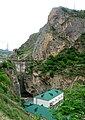
Dam of the Gergebiler reservoir with hydroelectric power station
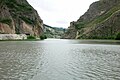
Gergebiler reservoir


history
The place originated in the Middle Ages, probably no later than the 13th century. During the Caucasus War , the Russian army under General Johann (Karl) Fäsi established a military post there. On August 30, 1944, Gergebil became the administrative seat of a newly created Rajons named after him.
Population development
| year | Residents |
|---|---|
| 1897 | 1428 |
| 1959 | 2600 |
| 1970 | 3217 |
| 1979 | 3366 |
| 1989 | 3755 |
| 2002 | 4770 |
| 2010 | 5195 |
Note: census data
traffic
Gergebil is located on the regional road 82K-009, which begins 10 km northwest at the Arakani Bridge (Arakanski most) at the confluence of the Karakoisu in the Avarskoje Koisu and continues to the southeastern district centers of Kumuch , Watschi , Tpig , Chiw and Kassumkent . Up the Karakoisu there is a connection via the regional road 82K-035 to the 82K-005 which runs 10 km away from Makhachkala via Buinaksk and Levaschi on to Gunib . The nearest train stations are in Buinaksk, 40 km to the north as the crow flies, the end point of a branch line from Shamchal near Makhachkala, and 70 km east in Isberbasch , accessible via Levashi - Sergokala , on the Rostov-on-Don - Makhachkala - Baku route .
Web links
Individual evidence
- ↑ a b Itogi Vserossijskoj perepisi naselenija 2010 goda. Tom 1. Čislennostʹ i razmeščenie naselenija (Results of the All-Russian Census 2010. Volume 1. Number and distribution of the population). Tables 5 , pp. 12-209; 11 , pp. 312–979 (download from the website of the Federal Service for State Statistics of the Russian Federation)
| Cities |
Buinaksk S / R | Hasavyurt S / R | Dagestanskije Ogni S | Derbent S / R | Isberbash S | Yuzhno-Sukhokumsk S | Kaspiysk S | Kisiljurt S / R | Kisljar S / R | Makhachkala S. |
|
| Urban-type settlements |
Alburican | Achi-Su | Bawtugai | Beliji | Dubki | Kjachulai | Komsomolski | Leninkent | Mamedkala | Manas | Nowy Kjachulai | Nowy Sulak | Shamhal | Shamilkala | Semender | Sulak | Tarki | Tjube |
|
| Other Rajon centers |
Eighty | Agwali | Akusha | Babajurt | Beshta U | Botlich | Chebda | Chiw | Chunsach | Chuchni | Dylym | Gergebil | Gunib | Karabudachkent | Karata | Treasury | Kidero | Cork mask | Kumuch | Kurach | Levaschi | Majalis | Magaramkent | Mechelta | Nowokajakent | Novolakskoye | Rutul | Sergokala | Tarumowka | Terekli-Mekteb | Tljarata | Tpig | Unzukul | Urkarach | Uzukchai | Watschi | Zurib |