Rottenbach (Upper Austria)
|
Rottenbach
|
||
|---|---|---|
| coat of arms | Austria map | |
|
|
||
| Basic data | ||
| Country: | Austria | |
| State : | Upper Austria | |
| Political District : | Grieskirchen | |
| License plate : | GR | |
| Surface: | 14.54 km² | |
| Coordinates : | 48 ° 12 ' N , 13 ° 41' E | |
| Height : | 424 m above sea level A. | |
| Residents : | 1,093 (January 1, 2020) | |
| Population density : | 75 inhabitants per km² | |
| Postal code : | 4681 | |
| Area code : | 07732 | |
| Community code : | 4 08 23 | |
| NUTS region | AT311 | |
| Address of the municipal administration: |
Rottenbach 12 4681 Rottenbach |
|
| Website: | ||
| politics | ||
| Mayor : | Alois Stadlmayr ( ÖVP ) | |
|
Municipal Council : (2015) (13 members) |
||
| Location of Rottenbach in the Grieskirchen district | ||
 Entering Rottenbach from the south |
||
| Source: Municipal data from Statistics Austria | ||
Rottenbach is a municipality in Upper Austria in the Grieskirchen district in the Hausruckviertel with 1093 inhabitants (as of January 1, 2020). The community is located in the judicial district of Grieskirchen .
geography
Rottenbach is located at an altitude of 424 m in the Hausruckviertel. The extension is 4.6 km from north to south and 5.1 km from west to east. The total area is 14.6 km². 10.3% of the area is forested, 81.5% of the area is used for agriculture.
Community structure
The municipality includes the following 19 localities (population in brackets as of January 1, 2020):
- Free (121)
- Grosswaldenberg (40)
- Höbeting (36)
- Wooden Houses (70)
- Inner Lake (147)
- Kleinwaldenberg (7)
- Lamperstorf (14)
- Mosenpoint (24)
- Mill Loan (27)
- Parz (51)
- Pommersberg (15)
- Poppenreith (33)
- Rappoltsberg (14)
- Rottenbach (102)
- Chessets (22)
- Stötten (47)
- Watzing (58)
- Weeg (212)
- Winkling (53)
The community consists of the cadastral communities Großwaldenberg, Innernsee and Rottenbach.
Neighboring communities
| Pram | Wendling | |

|
Hofkirchen | |
| Hague | Women |
coat of arms
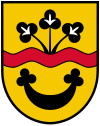
Blazon : a red wavy bar in gold; At the top three black, fan-shaped clovers grow from it, at the bottom a black crescent moon with clover leaf ends that is open at the top. The community colors are red-yellow-black.
The municipal coat of arms was awarded in 1988. The "red brook" symbolizes the place name as a talking coat of arms . The crescent moon with clover-leaf ends was taken from the coat of arms of the Innersee, whose ancestral seat was Schloss Innersee until the end of the 16th century. The three fan-shaped clover leaves come from the coat of arms of the Wiellinger family, who owned the castle from 1679 to 1766.
history
Originally located in the eastern part of the Duchy of Bavaria, the place belonged to the Duchy of Austria since the 12th century. First documented mention in 1130 (at that time the seat of the Rottenbach family). Rottenbach may have belonged to the ancestral estates of Alram von Steinbach and was sold to the Duke of Austria by his heirs, the Starhemberger, in 1379 together with the Starhemberg Fortress. Rottenbach has been part of the Principality of Austria ob der Enns since 1490 .
During the Napoleonic Wars , the place was occupied several times.
Since 1918 it belonged to the federal state of Upper Austria. After the annexation of Austria to the German Reich on March 13, 1938, then to the Gau Oberdonau . After 1945 the restoration of Upper Austria took place.
The community has been part of the judicial district of Grieskirchen since January 1, 2003, previously it belonged to the judicial district of Haag am Hausruck .
politics
Mayor is Alois Stadlmayr from the ÖVP.
Population development
In 1991 the municipality had 869 inhabitants according to the census, in 2001 it had 1,010 inhabitants. The reasons for this growth were a positive birth balance and a positive migration balance . From 2001 to 2011 there was a slight emigration (-5), but this was offset by the excess birth rate, so that the population rose to 1,087 in 2011.
Culture and sights

- Innersee Castle : moated castle (previously moated castle) in private ownership
- Rottenbach parish church
- Chapel in Rappoltsberg: The wooden chapel is approx. 300 years old and was built using a wooden block construction.
Sons of the place
- Jakob Eberlein (1575–1633), Bishop of Seckau
- Franz Wilflingseder (1922–1985), historian, director of the federal study library in Linz
- Alois Zauner (1925–2009), historian, director of the Upper Austrian Provincial Archives
Individual evidence
- ↑ Statistics Austria: Population on January 1st, 2020 by locality (area status on January 1st, 2020) , ( CSV )
- ^ Herbert Erich Baumert: The coats of arms of the cities, markets and communities of Upper Austria, 8th supplement (1988-1991) . In: Oberösterreichische Heimatblätter, Heft 3, 1992, p. 296, online (PDF; 4 MB) in the forum OoeGeschichte.at
- ^ Province of Upper Austria, results of the 2015 elections. Accessed on April 12, 2019 .
- ^ Statistics Austria, A look at the community of Rottenbach, population development. Retrieved April 12, 2019 .
Web links
- Map in the Digital Upper Austrian Room Information System ( DORIS )
- Further information about the municipality of Rottenbach can be found on the geographic information system of the federal state of Upper Austria .


