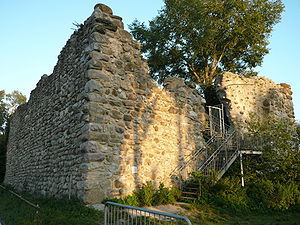
Schopflen ruins
| Schopflen ruins | ||
|---|---|---|
|
The ruin with access from the west side |
||
| Creation time : | 1000 to 1100 | |
| Castle type : | Niederungsburg | |
| Conservation status: | ruin | |
| Standing position : | Clerical | |
| Place: | Reichenau | |
| Geographical location | 47 ° 41 '11.2 " N , 9 ° 6' 1.8" E | |
| Height: | 397.4 m | |
|
|
||
The Schopflen ruin is the medieval ruin of a moated castle in the municipality of Reichenau in the district of Konstanz in Baden-Württemberg .
geography
The Schopflen castle ruins are located in the east of the Lake Constance island of Reichenau , at the end of the area separated from the island by the seven-meter-wide moat. It is located in the western section and on the southern side of the Pyramidenpappelallee (Pirminstraße or Landesstraße L 221 Konstanz-Reichenau), which today lines the Reichenauer Damm, at a height of 397.4 meters, and thus around 2.5 meters higher than the Lake level of the Untersee (394.93 meters). Originally, the weir structure was only accessible via a narrow shallow water area and was otherwise surrounded by deeper water. Only when the Reichenauer Damm was filled up in 1838 directly in the axis of the castle was the former defense tower accessible directly from the land.
The castle was 31 meters long in east-west extension (along today's avenue) and 19 meters wide. The masonry that has been preserved is up to nine meters high, and the loopholes that can still be seen clearly show that the outer wall of the defense building was originally 1.5-2.5 m higher and therefore at least 13-15 when measured from the surrounding water level m high. In addition, the tower once had a circumferential wooden battlement (plastered with clay) above the defensive wall, which was probably covered and projecting.
history
The first constructions of the moated castle go back to the 11th century. The castle was built by the abbots of the Reichenau monastery (Abbot Konrad von Zimmer ) to protect the shallows between the island and the mainland at low tide and was their seat from 1260 to 1294. In 1312 the two-storey castle was built by Abbot Diethelm von Castell rebuilt and destroyed in 1366 in the so-called “Konstanz fishing war”.
Today's condition and usage
The imposing ten meter high and 2.5 meter thick walls of the two-storey building of the former castle complex have been preserved. The nature conservation association NABU had an observation platform installed by the Radolfzell ornithological station inside the Mauergeviert .
literature
- J. Schmidt bridges: State of Baden-Württemberg. Castles, palaces and ruins . From the series: Bels excursion guide . Christian Belser Publishing House. Stuttgart 1980. ISBN 3-7630-1290-7
Individual evidence
- ↑ Geodata Viewer Baden-Württemberg ( page no longer available , search in web archives ) Info: The link was automatically marked as defective. Please check the link according to the instructions and then remove this notice. on a scale of about 1: 7000
Web links
- Schopflen castle ruins at burgenwelt.org
- Entry on Schopflen Castle in the private database "Alle Burgen".


