
St. Peter am Kammersberg
|
market community St. Peter am Kammersberg
|
||
|---|---|---|
| coat of arms | Austria map | |
 |
|
|
| Basic data | ||
| Country: | Austria | |
| State : | Styria | |
| Political District : | Murau | |
| License plate : | MU | |
| Surface: | 84.18 km² | |
| Coordinates : | 47 ° 11 ′ N , 14 ° 11 ′ E | |
| Height : | 850 m above sea level A. | |
| Residents : | 2,045 (January 1, 2020) | |
| Postal code : | 8843 | |
| Area code : | 03536 | |
| Community code : | 6 14 25 | |
| NUTS region | AT226 | |
| Address of the municipal administration: |
St. Peter 82 8843 St. Peter am Kammersberg |
|
| Website: | ||
| politics | ||
| mayor | Herbert Göglburger ( ÖVP ) | |
|
Municipal Council : ( 2020 ) (15 members) |
||
| Location of St. Peter am Kammersberg in the Murau district | ||
  |
||
.jpg) The town of St. Peter from the north, from the driveway to the Kammersberg, in the background the Stolzalpe ( 1817 m above sea level ) |
||
| Source: Municipal data from Statistics Austria | ||

St. Peter am Kammersberg is a market town in the Murau district in Upper Styria with 2045 inhabitants (as of January 1, 2020).
geography
Geographical location
The community is located north of the Mur Valley in the Katschtal and has a size of 84 square kilometers. The place is 850 meters above sea level.
Community structure
The municipality comprises seven localities (population as of January 1, 2020):
- Althofen (225)
- Feistritz am Kammersberg (315)
- Kammersberg (121)
- Mitterdorf (213)
- Peterdorf (235)
- Pöllau am Greim (264)
- St. Peter am Kammersberg (672)
The community consists of seven cadastral communities (area: as of December 31, 2017):
- Althofen (1,544.95 ha)
- Feistritz (887.13 ha)
- Kammersberg (498.58 ha)
- Mitterdorf (699.92 ha)
- Peterdorf (712.83 ha)
- Pöllau (3,563.82 ha)
- St. Peter (553.02 ha)
Neighboring communities
| Sölk | Oberwölz | |
| Schöder |
.svg)
|
Oberwölz |
| Rants | Murau | Teufenbach-Katsch |
history

The political community of St. Peter was established in 1849/50.
Incorporations
On January 1st, 1968 the communities Feistritz am Kammersberg, Pöllau am Greim and Peterdorf were incorporated.
Population development
If the birth balance and the migration balance were negative from 1981 to 1991 , there has been immigration since 1991.

Culture and sights
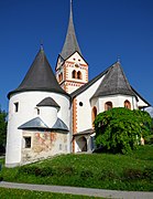
The Church of St. Peter, on the left the Karner ; towards the west

Frescoes on the east side of the Karner


Economy and Infrastructure
There were 37 agricultural and forestry holdings in the municipality, 21 of which were primarily employed (as of 2010). The manufacturing sector employed 426 people in 18 factories, eighty percent in the manufacture of goods and fourteen percent in construction. The service sector employed 361 people in 76 companies, almost half in trade and around a quarter in social and public services (as of 2011).
politics
The municipal council has 15 members.
- With the municipal council elections in Styria in 2000, the municipal council had the following distribution: 7 ÖVP, 6 SPÖ and 2 FPÖ.
- With the municipal council elections in Styria in 2005 , the municipal council had the following distribution: 9 SPÖ and 6 ÖVP.
- With the municipal elections in Styria in 2010 , the municipal council had the following distribution: 8 SPÖ, 6 ÖVP and 1 FPÖ.
- With the municipal elections in Styria in 2015 , the municipal council had the following distribution: 7 SPÖ, 7 ÖVP and 1 FPÖ.
- With the municipal council elections in Styria 2020 , the municipal council has the following distribution: 9 ÖVP, 5 SPÖ and 1 FPÖ.
mayor
- 2000-2007 Walter Perner (SPÖ)
- 2007-2018 Sonja Pilgram (SPÖ)
- since 2018 Herbert Göglburger (ÖVP)
Personalities
Honorary citizen
- 1969: Josef Krainer (1903–1971), Governor of Styria 1948–1971
Sons and daughters of the church
- Kurt Bauer (* 1961), historian
- Max Lercher (* 1986), politician
literature
- Walter Brunner : St. Peter am Kammersberg. The market town presents its history . St. Peter am Kammersberg 1997.
Web links
- 61425 - St. Peter am Kammersberg. Community data, Statistics Austria .
- www.st-peter-kammersberg.at Homepage of the community
Individual evidence
- ↑ Facts & Figures | St. Peter am Kammersberg. Retrieved December 29, 2019 .
- ↑ Statistics Austria: Population on January 1st, 2020 by locality (area status on January 1st, 2020) , ( CSV )
- ↑ Regionalinformation.zip (Excel file, 1,210 KB); accessed on January 4, 2018
- ↑ General State Law and Government Gazette for the Crown Land of Styria, Issue 21, October 7, 1850, No. 378.
- ↑ Law of December 18, 1967 on the change of territory of municipalities (Section 9, Paragraph 2)
- ^ Statistics Austria, A look at the community of St. Peter am Kammersberg, population development. (pdf) Accessed December 29, 2019 .
- ^ Statistics Austria, A look at the community of St. Peter am Kammersberg, agricultural and forestry operations. (pdf) Accessed December 29, 2019 .
- ^ Statistics Austria, A look at the community of St. Peter am Kammersberg, workplaces. (pdf) Accessed December 29, 2019 .
- ^ Statistics Austria, A look at the community of St. Peter am Kammersberg, employees. (pdf) Accessed December 29, 2019 .
- ^ Election result of the municipal council election 2005 in St. Peter am Kammersberg. State of Styria, March 13, 2005, accessed on July 1, 2020 .
- ^ Election result of the municipal council election 2010 in St. Peter am Kammersberg. State of Styria, March 21, 2010, accessed on July 1, 2020 .
- ^ Election result of the 2015 municipal council election in St. Peter am Kammersberg. State of Styria, March 22, 2015, accessed on July 1, 2020 .
- ↑ Results of the municipal council election 2020 in St. Peter am Kammersberg. State of Styria, June 28, 2020, accessed on July 1, 2020 .
- ↑ Herbert Göglburger is the clear winner. meinviertel.at, June 28, 2020.
- ↑ Südost-Tagespost (November 16, 1969), p. 4.
- ↑ Marktgemeinde St. Peter am Kammersberg (Ed.): From St. Peter a. Kbg via Graz to Vienna . No. 1 , April 2018, p. 13 ( online [PDF; accessed October 26, 2019]).
Krakow | Mills | Murau | Neumarkt in Styria | Niederwölz | Oberwölz | Ranten | Sankt Georgen am Kreischberg | Saint Lambrecht | St. Peter am Kammersberg | Scheifling | Schöder | Stadl-Predlitz | Teufenbach-Katsch
Communities dissolved since 1945: Dürnstein | Single | Falkendorf | Feistritz am Kammersberg | Freiberg | Frojach | Frojach-Katsch | Jakobsberg | Katsch an der Mur | Krakaudorf | Krakauhintermühlen | Cracow shadow | Kulm am Zirbitz | Laßnitz near Murau | Lind at Scheifling | Mariahof | Neumarkt in Styria | Noreia | Oberwölz city | Oberwölz area | Perchau on the saddle | Peterdorf | Pöllau am Greim | Predlitz | Predlitz-Turrach | Rinegg | Santa bubbles | Sankt Georgen bei Neumarkt | Sankt Georgen ob Murau | Sankt Lorenzen bei Scheifling | Sankt Marein near Neumarkt | Sankt Ruprecht ob Murau | St. Ruprecht-Falkendorf | Sankt Veit in the area | Schönberg-Lachtal | Seebach | Stadl an der Mur | Stolzalpe | Teufenbach | Drafts | Triebendorf | Winklern near Oberwölz | Zeutschach