
Glovelier
| Glovelier | ||
|---|---|---|
 |
||
| State : |
|
|
| Canton : |
|
|
| District : | Delémont | |
| Municipal municipality : | Haute-Sorne | |
| Postal code : | 2855 | |
| former BFS no. : | 6714 | |
| Coordinates : | 582.28 thousand / 242 678 | |
| Height : | 515 m above sea level M. | |
| Area : | 14.34 km² | |
| Residents: | 1193 (December 31, 2012) | |
| Population density : | 83 inhabitants per km² | |
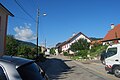
 Glovelier village center with a view of the church |
||
| map | ||
|
||


Glovelier was a municipality in the Delémont district of the canton of Jura in Switzerland . The former German name Lietingen is no longer used today. On January 1, 2013, it merged with the municipalities of Bassecourt , Courfaivre , Soulce and Undervelier to form the new municipality of Haute-Sorne .
geography

Glovelier is 515 m above sea level. M. , twelve kilometers west-southwest of the canton capital Delémont (linear distance ). The former street line village extends in the lowlands of the Tabeillon brook , in the far west of the Delsberg basin , a wide valley in the Jura .
The area of the 14.4 km² large municipal area comprises a section of the intensely agricultural plain of the Delsberg basin. In the west, the community area extends to the Jura ridge of Mont Russelin (up to 911 m above sea level ), which separates the Doubstal from the Delsberg basin, and the south-western part is taken up by the deeply cut valley of the Tabeillon. This drains the area east to the Sorne , a left tributary of the Birs . To the south the community extends to the chain of Saulcy and has here with 1020 m above sea level. M. its highest point. In 1997, 8% of the municipal area was accounted for by settlements, 49% for forests and woodlands and 43% for agriculture.
Glovelier includes the hamlet of Sceut , which is 870 m above sea level. M. is located on the northern slope of the Tabeillon and forms its own civil parish, as well as several individual farms. The neighboring municipalities of Glovelier are Boécourt , Bassecourt , Undervelier , Saulcy , Saint-Brais and Clos du Doubs .
population
With 1193 inhabitants (as of December 31, 2012) Glovelier was one of the medium-sized communities in the canton of Jura. 92.1% of the residents are French-speaking, 2.2% German-speaking and 1.8% Italian-speaking (as of 2000). The population of Glovelier was 537 in 1850 and 634 in 1900. In the course of the 20th century, the population increased slowly but continuously. Increased growth rates have been observed since 1990 (990 inhabitants).
economy
Glovelier developed from a farming village to an industrial community at the end of the 19th century. There are jobs in the watch industry (manufacture of watch cases) and in a large sawmill. Thanks to the good transport links, an industrial zone was created north of the village.
traffic
The community has good transport links. It is located on the thoroughfare from Delémont to La Chaux-de-Fonds and has its own connection to the section of the A16 motorway from Delémont to Pruntrut , which was opened in 1998 and which is to be connected to both the Swiss national road network and the French motorway network by 2015. On October 15, 1876, the Delémont – Glovelier railway line was opened, and on March 30, 1877, the western continuation of the railway line through the Mont-Russelin tunnel to Saint-Ursanne and Pruntrut was opened. The RSG opened a line to Saignelégier on May 21, 1904 ; After the merger to form Chemins de fer du Jura (CJ), the line was shut down in 1948, converted to meter gauge and reopened on October 4, 1953, since then it has led via Saignelégier to La Chaux-de-Fonds. Since 2004 the village has been served in the direction of Pruntrut and Basel SBB by the continuation of the S3 line of the Basel S-Bahn .
history
During excavations, pottery from the late Bronze Age was discovered , which indicates that the municipality was already settled around 1000 BC. Furthermore, there were finds of Roman coins on a road that was used in Roman times .
Glovelier was first mentioned in 1139 as Lolenviler in a document from Pope Innocent II. As one of the 13 free villages of the Delsberg rule, Glovelier came to the Duchy of Basel in 1271 . From 1793 to 1815 it belonged to France and was initially part of the Département du Mont-Terrible , from 1800 connected to the Département Haut-Rhin . By decision of the Congress of Vienna , the place came to the canton of Bern in 1815 and on January 1, 1979 to the newly founded canton of Jura.
Attractions
Some houses from the 17th to 19th centuries have been preserved in the village center. The former school was built in the classical style of the 19th century. In the upper part of the village is the Saint-Maurice church, which was built between 1923 and 1924. The parish of Glovelier is mentioned as early as the 12th century, to which Saulcy belonged until 1802 and 1874–1935.

railway station
Bahnhofquartier

Village shop
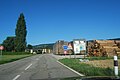
Sawmill at the entrance to the village

Au Village
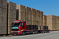
Sleeper saw mill Ets Röthlisberger SA

Multipurpose hall

Primary school house and gym

Parish Church of St-Maurice

railway station


Web links
- Official website of the municipality of Glovelier
- François Kohler: Glovelier. In: Historical Lexicon of Switzerland .
Boécourt | Bourrignon | Châtillon | Courchapoix | Courrendlin | Courroux | Courtételle | Delémont | Develier | Ederswiler | Haute-Sorne | Mervelier | Mettembert | Movelier | Pleigne | Rossemaison | Saulcy | Soyhières | Val Terbi
Former municipalities: Bassecourt | Corban | Courfaivre | Glovelier | Montsevelier | Rebeuvelier | Soulce | Undervelier | Vellerat | Vermes | Vicques
Canton of Jura | Districts of the Canton of Jura | Municipalities of the Canton of Jura