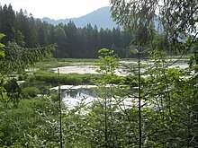
Taubensee (Ramsau)

Taubensee is one of the four Gnotships of the municipality of Ramsau near Berchtesgaden . The district is named after the small pigeon lake in the northwest .
geography
The Gnotschaft Taubensee is located in the north-western part of the municipality of Ramsau. It extends in the east to the Schwarzeckerbach , which flows into the Ramsauer Ache . There it borders on the Gnotschaft Schwarzeck . Further north it is separated from Schwarzeck by the Gesengschneid, which is up to 1,329 meters high. The western border is the Lattenbach and further south from the bridge over the Lattenbach the Kunterweg , where Taubensee borders on the Gnotschaft Antenbichl . To the northwest of the Gnotschaft lies the uninhabited and formerly Ausmärkische Taubensee forest , which was incorporated into Ramsau in 1984. Just like the Gnotschaft Schwarzeck and Au , Taubensee has a share in the built-up interior area in the valley of the Ramsauer Ache, which is referred to as the village of Ramsau or the town center , over a length of around 415 meters from house numbers "Im Tal" 73 to 97 (without 74 - to Schwarzeck, and 96 - to Antenbichl). This means that the historic hamlet of Ramsau is located, for example, from the parish church of St. Sebastian to the Oberwirt in the Gnotschaft Taubensee.
In the valley on the Ramsauer Ache , today's state road 2099 runs through the Gnotschaft to the Hirschbichl. It used to be used to transport salt. Above the Taubensee, the B305 , here part of the German Alpine Road , leads to Schneizlreuth to the Schwarzbachwacht mountain pass .
In the official local directory for the census on May 25, 1987, the Taubensee has a population of 396, in 93 buildings with living space and 142 residential units. This makes Taubensee the second largest district of Ramsau after the Gnotschaft Au.
history
Probably from the end of the 14th century Taubensee together with Antenbichl formed the 2nd Gnotschaftsgebiet of the "Ur gnotschaft " Ramsau in the Berchtesgadener Land , via the " Closed Forest District " and then settled heartland from 1155 the monastery Berchtesgaden and from 1559 to 1803 the imperial monastery Fürstpropstei Berchtesgaden as a small, independent principality .
After three changes of rulership in quick succession, in 1810 the Berchtesgadener Land with its Gnotships was annexed to the Kingdom of Bavaria and from 1812 Ramsau became a community with Taubensee and Antenbichl as two separate Gnotships.
Since the size and structure of the municipality of Ramsau near Berchtesgaden were not changed by the regional reform in Bavaria in the 1970s , Taubensee is still a district or a Gnotschaft of this municipality today.
Attractions
There are a total of 20 listed buildings in the Taubensee Gnotschaft .
Particularly outstanding are the parish church of St. Sebastian , built in 1512, which became world famous for the landscape painters, and the pilgrimage church of Maria Kunterweg , which was built from 1731 to 1733 and is one of the most original Bavarian rococo buildings.
The Hindenburglinde is one of the nationally important trees .
Individual evidence
- ↑ Die Gnotschaft in der Ramsau , Ramsauer Bladl, number 44, May 2011 ( Memento of the original from September 24, 2015 in the Internet Archive ) Info: The archive link was inserted automatically and has not yet been checked. Please check the original and archive link according to the instructions and then remove this notice. (PDF; 1.7 MB), page 1–2
- ↑ Minutes of the public meeting of September 20, 2011 of the Ramsau municipal council - on page 3 of the PDF file it says: “The building plot (..), Ramsau district, is located inside. In the land use plan of the municipality of Ramsau, the area is shown as a village area. "
- ↑ ramsau.de ( Memento of the original from January 28, 2012 in the Internet Archive ) Info: The archive link was inserted automatically and has not yet been checked. Please check the original and archive link according to the instructions and then remove this notice. Under "Numbers, data, facts" the indication of the altitude of the town center
- ↑ Historical land map in the Bavaria Atlas with the hamlet of Ramsau (today's Oberwirt is listed there as the host ).
- ↑ Bavarian State Office for Statistics and Data Processing (Ed.): Official local directory for Bavaria, territorial status: May 25, 1987 . Issue 450 of the articles on Bavaria's statistics. Munich November 1991, DNB 94240937X , p. 71 ( digitized version ).
- ↑ Dieter Albrecht : Fürstpropstei Berchtesgaden - Statistical overview based on the status of 1698. I. District and Nursing Court Berchtesgaden. Chapter: Gnotschaft Ramsau In: Historical Atlas of Bavaria . Part Altbayern, Heft 7, Munich 1954, p. 26
- ↑ baufachinformation.de ( Memento of the original of March 8, 2007 in the Internet Archive ) Info: The archive link was automatically inserted and not yet checked. Please check the original and archive link according to the instructions and then remove this notice. - Assessment of the pilgrimage church Maria Kunterweg by the Fraunhofer IRB
- ↑ Bernd Ullrich, Stefan Kühn, Uwe Kühn: Our 500 oldest trees: Exclusively from the German Tree Archives . BLV Buchverlag GmbH & Co. KG, Munich 2009, ISBN 978-3-8354-0376-5 , p. 282 .
Coordinates: 47 ° 37 ' N , 12 ° 53' E


