
Tiglieto
| Tiglieto | ||
|---|---|---|

|
|
|
| Country | Italy | |
| region | Liguria | |
| Metropolitan city | Genoa (GE) | |
| Coordinates | 44 ° 32 ' N , 8 ° 37' E | |
| height | 500 m slm | |
| surface | 24.5 km² | |
| Residents | 513 (Dec. 31, 2019) | |
| Population density | 21 inhabitants / km² | |
| Post Code | 16010 | |
| prefix | 010 | |
| ISTAT number | 010061 | |
| Popular name | Tiglietesi | |
| Patron saint | L'Assunta | |

Tiglieto ( Ligurian o Tilieto ) is an Italian municipality in the metropolitan city of Genoa with 513 inhabitants (as of December 31, 2019).
geography
The municipality is located in the Orba valley in the mountainous hinterland of the Ligurian capital Genoa . The provincial borders of Savona and Alessandria run in close proximity to Tiglieto . The image of the municipality is determined by the morphology of the Ligurian Apennines .
Together with three other municipalities, Tiglieto forms the mountain community Valli Stura e Orba and is also located with its territory in the Beigua Nature Park .
Individual evidence
- ↑ Statistiche demografiche ISTAT. Monthly population statistics of the Istituto Nazionale di Statistica , as of December 31 of 2019.
Web links
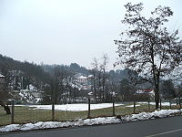
Panorama of Tiglieto (January 2006)

Bridge over the Orba River (April 2007)


Arenzano | Avegno | Bargagli | Bogliasco | Borzonasca | Busalla | Camogli | Campo Ligure | Campomorone | Carasco | Casarza Ligure | Casella | Castiglione Chiavarese | Ceranesi | Chiavari | Cicagna | Cogoleto | Cogorno | Coreglia Ligure | Crocefieschi | Davagna | Fascia | Favale di Malvaro | Fontanigorda | Genoa | Gorreto | Isola del Cantone | Lavagna | Leivi | Lorsica | Lumarzo | Masone | Mele | Mezzanego | Mignanego | Moconesi | Moneglia | Montebruno | Montoggio | Ne | Neirone | Orero | Pieve Ligure | Portofino | Propata | Rapallo | Recco | Rezzoaglio | Ronco Scrivia | Rondanina | Rossiglione | Rovegno | San Colombano Certénoli | Sant'Olcese | Santa Margherita Ligure | Santo Stefano d'Aveto | Savignone | Serra Riccò | Sestri Levante | Sori | Tiglieto | Torriglia | Tribogna | Uscio | Valbrevenna | Vobbia | Zoagli