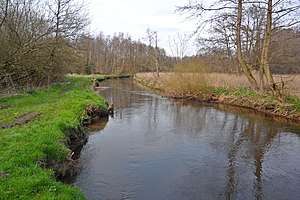
Lower Estetal
|
Lower Estetal
|
||
|
Este near Nindorf |
||
| location | South of Buxtehude , Stade district , Lower Saxony | |
| surface | 263 ha | |
| Identifier | NSG LÜ 342 | |
| WDPA ID | 555690902 | |
| FFH area | 238 ha | |
| Geographical location | 53 ° 27 ' N , 9 ° 41' E | |
|
|
||
| Sea level | from 5 m to 28 m | |
| Setup date | December 14, 2018 | |
The Lower Estetal is a nature reserve in the Lower Saxony town of Buxtehude and the municipality of Beckdorf in the joint municipality of Apensen in the Stade district .
The nature reserve with the sign NSG LÜ 342 is approximately 263 hectares . Of this, around 189 hectares are in the city of Buxtehude and around 74 hectares in the community of Beckdorf. The nature reserve is part of the FFH area "Este, Bötersheimer Heide, Glüsinger Bruch and Osterbruch " on 238 hectares . The area is almost completely surrounded by the "Este- und Goldbecktal" conservation area. In the scope of the Nature Conservation Ordinance, the landscape protection area became part of the nature reserve. The area has been under nature protection since December 14, 2018. The responsible lower nature conservation authority is the district of Stade.
The nature reserve is located south of Buxtehude. It includes the Este tal from the circular border district Harburg to the crossing of the Este by the Federal Highway 73 in Buxtehude, and a 2.5 km long valley portion of Goldbach , which here runs along the circular boundary. The nature reserve is characterized by an alternation of alluvial forests and grasslands of varying degrees of moisture with reed beds and tall herbaceous vegetation. The forests are characterized as alder-ash or alder swamp forests with black alder and common ash and moist oak-hornbeam forests with pedunculate oak and hornbeam . They particularly dominate the northern part of the nature reserve between Heimbruch and Buxtehude. In places, grassland areas are embedded in the forests, many of which have fallen fallow . Grasslands dominate the southern area of the protected area in the estuary that widens here. Most of the grasslands are farmed extensively. Valuable wet meadows can also be found in the southern area of the nature reserve in particular . Reeds and large sedge beds spread out over fallow areas . In addition, hybrid poplar forests can be found several times. At the edges of the valley, mixed oak forests and pine forests grow in places.
The Este runs in the nature reserve in part relatively natural with flooding water vegetation and riparian herbaceous vegetation . It is of particular importance as a habitat and migratory corridor for various fish , including sea and brown trout , hazel , chub , gudgeon and loach, and the round- mouthed sea , river and brook lamprey as well as for the otter . Occasionally, bitterling has also been detected in the area. Oxbows and small bodies of water are the habitat of various amphibians , including the crested newt . The nature reserve is the habitat of the black stork and various bat species .
Web links
- Nature reserve "Unteres Estetal" in the database of the Lower Saxony State Office for Water Management, Coastal and Nature Conservation (NLWKN)
Individual evidence
- ^ Este, Bötersheimer Heide, Glüsinger Bruch and Osterbruch , profiles of the Natura 2000 areas, Federal Agency for Nature Conservation . Retrieved January 17, 2019.
- ↑ Ordinance on the "Unteres Estetal" nature reserve , Stade district, January 4, 2019. Accessed January 17, 2019.


