
US Highway 101
|
|
|
|---|---|
| map | |

|
|
| Basic data | |
| Overall length: | 1540mi / 2478 km |
| Opening: | 1926 |
| States: |
California Oregon Washington |
| Starting point: |
|
| End point: |
|

The US Highway 101 (or US Route 101 ) is an American highway with a length of 2,478 kilometers. It opened in 1926.
It runs along the west coast of the USA in a north-south direction with the endpoints Olympia in the north and Los Angeles in the south. The road crosses the states of Washington , Oregon and California . In Oregon it has the nickname "Coast Highway in Oregon", in Washington and parts of California the nickname "Pacific Highway". In San Francisco , the highway crosses the Golden Gate Bridge .
According to the naming scheme of the AASHTO , US highways with three-digit numbers serve as feeders for the respective highway with the numbering that results from the last two digits; here the US Highway 1 . In this case, however, it is a violation of this scheme; US Highway 101 does not serve as a feeder to US Highway 1, which follows the east coast of the United States. Geographically, the two highways are as far apart as possible.
With the opening of the nearly parallel Interstate 5 in 1957, the street lost its importance. Due to its scenic route along the Pacific coast , it is a popular destination for tourists, especially the section in Oregon , where it leads along the Jessie M. Honeyman Memorial State Park .
The following other major roads cross the highway from south to north:
- I-5 / I-10 / CR-60 near Los Angeles (California)
- I-405 near Los Angeles
- I-280 / I-680 / I-880 near San José (California)
- I-80 / I-280 near San Francisco (California)
- I-580 in San Rafael, California (California)
- US 199 at Crescent City (California)
- US 20 near Newport (Oregon)
- US 26 north of Cannon Beach (Oregon)
- US 30 at Astoria (Oregon)
- US 12 near Aberdeen (Washington)
- I-5 (second cross) at Tumwater, Washington
gallery
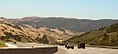
Near San Luis Obispo

The highway in downtown Los Angeles
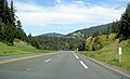
US Route 101 in Mendocino County
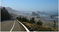
At Hunter's Cove on the Oregon coast

US 101 between Oregon and Washington at the Astoria Bridge

.jpg)


See also
Web links
- End of US Highways (English)
US Highway 1 |
2 |
3 |
4 |
5 |
6 |
7 |
8 |
9 |
10 |
11 |
12 |
13 |
14 |
15 |
16 |
17 |
18 |
19 |
20 |
21 |
22 |
23 |
24 |
25 |
26 |
27 |
28 |
29 |
30 |
31 |
32 |
33 |
34 |
35 |
36 |
37 |
38 |
40 |
41 |
42 |
43 |
44 |
45 |
46 |
48 |
49 |
50 |
51 |
52 |
53 |
54 |
55 |
56 |
57 |
58 |
59 |
60 |
61 |
62 |
63 |
64 |
65 |
66 |
67 |
68 |
69 |
70 |
71 |
72 |
73 |
74 |
75 |
76 |
77 |
78 |
79 |
80 |
81 |
82 |
83 |
84 |
85 |
87 |
89 |
89A |
90 |
91 |
92 |
93 |
94 |
95 |
96 |
97 |
98 |
99 |
101 |
150 |
151 |
163 |
218 |
400 |
412 |
425
This is a list of the major routes used by the US highway system. Secondary routes can be reached from the article of the respective main route (with identical end digits).
See also: List of United States Highways .