
Bördeland
| coat of arms | Germany map | |
|---|---|---|

|
Coordinates: 51 ° 58 ' N , 11 ° 41' E |
|
| Basic data | ||
| State : | Saxony-Anhalt | |
| County : | Salzlandkreis | |
| Height : | 91 m above sea level NHN | |
| Area : | 92.18 km 2 | |
| Residents: | 7535 (Dec. 31, 2019) | |
| Population density : | 82 inhabitants per km 2 | |
| Postal code : | 39221 | |
| Primaries : | 03929, 03928 (Eggersdorf), 039296 (Welsleben), 039297 (beers, Eickendorf) | |
| License plate : | SLK, ASL, BBG, SBK, SFT | |
| Community key : | 15 0 89 042 | |
| Community structure: | 7 districts | |
| Address of the municipal administration: |
Magdeburger Strasse 3 39221 Bördeland |
|
| Website : | ||
| Mayor : | Bernd Nimmich ( SPD ) | |
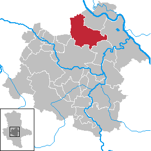
| Location of the municipality of Bördeland in the Salzlandkreis | ||
  |
||

Bördeland is a municipality in the northern Salzlandkreis (Saxony-Anhalt). It was created on December 29, 2007 from the merger of the seven communities of Biere , Eggersdorf , Eickendorf , Großmühlingen , Kleinmühlingen , Welsleben and Zens . The administration of the municipality is based in the district of Biere.
geography
The municipality is located in the southeast of the Magdeburg Börde . It borders in the north on the state capital Magdeburg , in the east on the city of Schönebeck (Elbe) as well as the community Gnadau and the city Barby , in the south on the cities Calbe (Saale) and Staßfurt and in the west on the community Borne (all Salzlandkreis) as well the municipality of Sülzetal (district of Börde).
The following localities belong to the municipality:
| Locality | Residents |
  (clickable map) |
|---|---|---|
|
|
2,431 | |
|
|
1,240 | |
|
|
1,143 | |
|
|
1,059 | |
|
|
640 | |
|
|
1,835 | |
|
|
288 |
history
The area of the municipality of Bördeland was partially settled in prehistoric times, as excavations near Biere show. The first Germanic settlers settled in Biere before the 3rd century. Großmühlingen and Welsleben emerged as Thuringian settlements between the 4th and 6th centuries . The districts of Kleinmühlingen and Zens are among the Slavic foundations up to the 9th century . The entire settlement area between the Elbe, Saale and Bode was initially the northern Thuringia , which emerged in the 6th century and whose dominant structure ceased in the 11th century at the latest. The term Börde , which was officially mentioned for the first time in 1314 , then appeared as a landscape designation .
In 803, Emperor Charlemagne founded the county of Mühlingen , to which all districts of Bördeland initially belonged. It was subordinated to the Diocese of Halberstadt , while Margrave Gero became a liege lord . The fiefdom passed to the Ascanians under Albrecht the Bear in 1034 , followed by the Counts of Dornburg around 1130 and the Counts of Arnstein from 1240 . After the Arnsteiners died out in 1659, the county of Mühlingen fell apart. While Großmühlingen and Kleinmühlingen came back to the Ascanians, the rest of the county, including the rest of today's Bördeland, went to the Archdiocese of Magdeburg .
The towns of Bördeland were hit several times by armed conflicts and also by the plague epidemic of 1350. They suffered the worst from the Thirty Years' War , when their area became the deployment area of the imperial troops against Magdeburg . After looting and pillage, most of the residents fled to nearby Salt . The inhabitants did not return until the middle of the 17th century, and together with new settlers the villages recovered. New hardship arose in 1806 with the march through the Napoleonic troops on their way to Berlin, which again led to looting and subsequent contributions . From 1807 to 1813 the places belonging to the former Archdiocese of Magdeburg, which had been converted into the Duchy of Magdeburg in 1680 , belonged to the French Kingdom of Westphalia . Großmühlingen and Kleinmühlingen still remained Ascanian property (Principality of Anhalt-Bernburg ).
After the defeat of Napoleon, the French-occupied places came to Prussia and, with the exception of Welsleben, became the newly formed district of Calbe a./S. assigned. Welsleben came to the Wanzleben district , while the two Mühlingen continued to form a Anhalt exclave and were assigned to the Bernburg district . With the first opening of the lignite mines in the Eggersdorfer-Mühlinger Mulde in 1847, the industrial age began in the Bördeland area. Since the Anhalt Duke Alexander Carl forbade the use of the Magdeburg – Leipzig railway via his exclave, Eggersdorf and Eickendorf only got their own stations with the Schönebeck – Güsten railway in 1857 . Despite the industrial revolution , the villages of Bördeland continued to be dominated by agriculture. This pattern changed dramatically after the end of the Second World War .
The war ended for the villages when American troops occupied the area in mid-April 1945. After a short period with British occupation, the Bördeland area came under the control of the Soviet zone of occupation . This immediately ordered a land reform , to which all farms with over 100 hectares of land and Großmühlingen Castle fell victim. After the GDR was founded in 1949, a district reform was carried out in 1950, with which all places of Bördeland were incorporated into the newly created district of Schönebeck. In the course of the collectivization of GDR agriculture, which began in 1952, agricultural production cooperatives (LPG) were created in the Bördelandorten . In 1960 all villages were "fully cooperative". After the political change in 1989 , agriculture was re-privatized. On January 1, 2005, the Bördeland municipalities merged to form the Southeastern Bördeland Administrative Community to handle the administrative business. The administrative community was formed from the dissolved administrative communities Bördeland and Ostliche Börde. After public hearings in all municipalities of the administrative community, it was decided to amalgamate the municipalities on December 29, 2007 to form the unified municipality "Bördeland".
politics
Municipal council
After the local elections on May 25, 2014 , the local council of the municipality of Bördeland is composed as follows (with comparative figures from the 2009 election):
| Party / list | Seats 2014 | Seats 2009 |
|---|---|---|
| Christian Democratic Union (CDU) | 7th | 8th |
| Social Democratic Party of Germany (SPD) | 5 | 5 |
| Free Democratic Party (FDP) | 1 | _ |
| Citizens' initiative Welsleben | 3 | 3 |
| PRO Eggersdorf | 1 | 2 |
| FWG Beers eV | 1 | 1 |
| BfB eV | - | 1 |
The turnout in 2014 was 45.5%.
mayor
In April 2015 Bernd Nimmich (SPD) was re-elected.
coat of arms
The coat of arms was approved by the district on April 22, 2008.
Blazon : “Quartered; Fields 1 and 4: in red a golden grain yolk, fields 2 and 3: in silver a black miner's tooth. "
The symbolism is linked to the two main branches of industry, agriculture and mining. The new municipality took over the coat of arms of the former administrative association Östliche Börde . The coat of arms was designed by the Magdeburg municipal heraldist Jörg Mantzsch .
flag
The flag is striped yellow and red and has the coat of arms in the middle.
Partnerships
The district of Großmühlingen is in partnership with the village of Otze , the district of Kleinmühlingen is in partnership with the village of Ramlingen-Ehlershausen . Otze and Ramlingen-Ehlershausen both belong to the town of Burgdorf in Lower Saxony .
Web links
Individual evidence
- ↑ State Statistical Office Saxony-Anhalt, population of the municipalities - as of December 31, 2019 (PDF) (update) ( help ).
- ^ StBA: Changes in the municipalities in Germany, see 2007
- ↑ http://www.gem-boerdeland.de/gemeinderat.htm
- ↑ http://www.stala.sachsen-anhalt.de/wahlen/bm15/erg/gem/bm.15089042.20150426.ergtab.dr.html
- ↑ a b Official Journal of the District No. 24/2008 page 265 ( Memento of the original from March 4, 2016 in the Internet Archive ) Info: The archive link was automatically inserted and not yet checked. Please check the original and archive link according to the instructions and then remove this notice.
- ↑ Entry about the partnerships on the homepage of the city of Burgdorf.Retrieved on April 23, 2019, 12:29 am
Cities: Alsleben (Saale) | Aschersleben | Barby | Bernburg (Saale) | Calbe (Saale) | Leeches | Güsten | Hecklingen | Skills | Nienburg (Saale) | Schönebeck (Elbe) | Zealand | Staßfurt . Municipalities: Bördeaue | Börde-Hakel | Bördeland | Borne | Giersleben | Ilberstedt | Plötzkau | Wolmirsleben .