
Zeillern
|
market community Zeillern
|
||
|---|---|---|
| coat of arms | Austria map | |
 |
|
|
| Basic data | ||
| Country: | Austria | |
| State : | Lower Austria | |
| Political District : | Amstetten | |
| License plate : | AT THE | |
| Surface: | 21.46 km² | |
| Coordinates : | 48 ° 8 ' N , 14 ° 48' E | |
| Height : | 290 m above sea level A. | |
| Residents : | 1,877 (January 1, 2020) | |
| Population density : | 87 inhabitants per km² | |
| Postcodes : | 3311 | |
| Area code : | 07472 | |
| Community code : | 3 05 44 | |
| NUTS region | AT121 | |
| Address of the municipal administration: |
Schlossstrasse 31 3311 Zeillern |
|
| Website: | ||
| politics | ||
| Mayor : | Friedrich Pallinger ( ÖVP ) | |
|
Municipal Council : ( 2020 ) (19 members) |
||
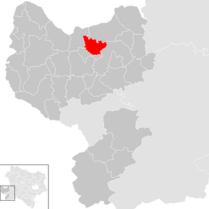
| Location of Zeillern in the Amstetten district | ||
  |
||
| Source: Municipal data from Statistics Austria | ||

Zeillern is an Austrian market town with 1,877 inhabitants (as of January 1, 2020) in the Amstetten district in Lower Austria .
geography
Zeillern is located in the heart of the Mostviertel in Lower Austria. 15.41 percent of the area of the market town is forested.
Community structure
The market town of Zeillern consists only of the cadastral community of the same name .
It includes numerous districts: Destelberg, Dorf, Edla, Engersdorf, Flachsberg, Friedlmühle, Gebetsberg, Groschopf, Hickersberg, Hörsdorf, Kirchholz, Kleinberg, Lemberg, Ludwigsdorf, Luppenberg, Oberzeillern, Pyhra, Rabenleiten, Reinthal, Reitzberg, Rosenfeld, Salzgrub and Schörghof , as well as several named individual farms: Am Steg, Dirnberg, Gatterbauer, Graben, Humpelhof, Kobl, Königshof, Krenberg, Limberg, Maischberg, Melbing, Mühlbrunn, Oberdona, Obere Grub, Obere Hub, Obernleiten, Pauleiten, Preinesberg, Reith, Rohra, Untere Grub, Untere Hub, Wieser and Wingersleiten.
Neighboring communities
| Wallsee-Sindelburg | Ardagger | |
.svg)
|
||
| Oed-Oehling | Amstetten |
history
In ancient times, the area was part of the Noricum province .
As early as 791, at the beginning of the Avar Wars , Charlemagne gave Zeillern to the Bavarian monastery Niederaltaich . The monastery established a mission center for the new Bavarian Ostland here . This donation was confirmed by King Ludwig the German in 863 .
Population development
According to the results of the 2001 census, there were 1,650 inhabitants. In 1991 the market town had 1,579 inhabitants, in 1981 1,568 and in 1971 1,505 inhabitants.
politics
The municipal council has 19 members.
- With the municipal council elections in Lower Austria in 1990, the municipal council had the following distribution: 17 ÖVP and 2 SPÖ.
- With the municipal council elections in Lower Austria in 1995, the municipal council had the following distribution: 14 ÖVP, 3 citizens' lists Zeillern and 2 SPÖ.
- With the municipal council elections in Lower Austria in 2000, the municipal council had the following distribution: 17 ÖVP and 2 SPÖ.
- With the municipal council elections in Lower Austria in 2005 , the municipal council had the following distribution: 16 ÖVP and 3 SPÖ.
- With the municipal elections in Lower Austria in 2010 , the municipal council had the following distribution: 16 ÖVP and 3 SPÖ.
- With the municipal council elections in Lower Austria in 2015 , the municipal council had the following distribution: 14 ÖVP and 5 SPÖ.
- With the municipal council elections in Lower Austria 2020 , the municipal council has the following distribution: 14 ÖVP, 3 SPÖ and 2 FPÖ.
- mayor
- until 2005 Heinrich Zarl (ÖVP)
- 2005–2012 Rupert Perger (ÖVP)
- since 2012 Friedrich Pallinger (ÖVP)
Culture and sights

.JPG)
- Zeillern Castle : The castle now houses a hotel and a seminar center
- Catholic parish church Zeillern hl. James the Elder: three-aisled, Gothic hall church with Romanesque components; Tower with a steep hipped roof, nave with a steep gable roof; consecrated to St. Jacob the Elder.
- For the design of the square between the parish church, the castle and the castle island with a so-called red carpet with the architect Caren Ohrhallinger, the market community received the Lower Austrian Village and Urban Renewal Prize in 2012.
- Chapel in Reitzberg, also called Reitschberger Chapel: In the right inner wall is a cannonball from the battle of Amstetten
economy
In 2001 there were 38 non-agricultural workplaces; according to the 1999 survey, there were 116 agricultural and forestry holdings. According to the 2001 census, 795 people were employed at the place of residence. The employment rate in 2001 was 49.03 percent. On average in 2003 there were 14 unemployed people in the area.
Web links
- Zeillern municipality
- 30544 - Zeillern. Community data, Statistics Austria .
Individual evidence
- ↑ Zeillern: Instead of six postcodes only one on ORF from February 18, 2019, accessed on February 19, 2019.
- ^ Hans Krawarik: settlement history of Austria: settlement beginnings, settlement types, settlement genesis , Verlag Lit, 2006, p. 126f
- ^ Result of the local council election 1995 in Zeillern. Office of the Lower Austrian State Government, March 30, 2000, accessed October 17, 2019 .
- ^ Election result of the municipal council election 2000 in Zeillern. Office of the Lower Austrian State Government, February 4, 2005, accessed on October 17, 2019 .
- ^ Election result of the local council election 2005 in Zeillern. Office of the Lower Austrian State Government, March 4, 2005, accessed on October 17, 2019 .
- ^ Election result of the municipal council election 2010 in Zeillern. Office of the Lower Austrian State Government, October 8, 2010, accessed on October 17, 2019 .
- ^ Election results for the 2015 municipal council elections in Zeillern. Office of the Lower Austrian State Government, December 1, 2015, accessed on October 17, 2019 .
- ↑ Results of the local council election 2020 in Zeillern. Office of the Lower Austrian State Government, January 26, 2020, accessed on March 1, 2020 .
- ↑ nonconform nt: Office for Architecture and Participation
- ↑ Lower Austria Village & Urban Renewal Prize for Zeillern in the Mostviertel noe-news.at, January 21, 2012
- ^ Anton Distelberger, Mysterious Mostviertel, pp. 155–156.

Allhartsberg | Amstetten | Ardagger | Aschbach Market | Behamberg | Biberbach | Ennsdorf | Ernsthofen | Ertl | Euratsfeld | Ferschnitz | Hague | Haidershofen | Hollenstein an der Ybbs | Kematen on the Ybbs | Neuhofen an der Ybbs | Neustadtl an der Donau | Oed-Oehling | Opponitz | Seitenstetten | Sonntagberg | St. Georgen am Reith | St. Georgen am Ybbsfelde | St. Pantaleon-Erla | St. Peter in der Au | St. Valentin | Strengberg | Viehdorf | Wallsee-Sindelburg | Weistrach | Winklarn | Wolfsbach | Ybbsitz | Zeillern
Cadastral communities: Zeillern
Location: Zeillern
Market place: Zeillern | Villages: Ludwigsdorf | Oberzeillern Weiler: Edla | Hickersberg | Hörsdorf | Lviv | Luppenberg | Reinthal Rotten: Destelberg | Flachsberg | Friedlmühle | Prayer Mountain | Groschopf | Kirchholz | Kleinberg | Rabenleiten | Reitzberg | Rosenfeld | Salzgrub | Schörghof Scattered Houses: Village | Pyhra Other locations: Zeillern Castle
Counting district: Zeillern