
Opponitz
|
Opponitz
|
||
|---|---|---|
| coat of arms | Austria map | |
 |
|
|
| Basic data | ||
| Country: | Austria | |
| State : | Lower Austria | |
| Political District : | Amstetten | |
| License plate : | AT THE | |
| Main town : | Home loan | |
| Surface: | 39.6 km² | |
| Coordinates : | 47 ° 52 ' N , 14 ° 49' E | |
| Height : | 422 m above sea level A. | |
| Residents : | 902 (January 1, 2020) | |
| Population density : | 23 inhabitants per km² | |
| Postcodes : | 3341, 3342 | |
| Area code : | 07444 | |
| Community code : | 3 05 24 | |
| NUTS region | AT121 | |
| Address of the municipal administration: |
House loan 21 3342 Opponitz |
|
| Website: | ||
| politics | ||
| Mayor : | Johann Lueger ( ÖVP ) | |
|
Municipal Council : ( 2020 ) (15 members) |
||
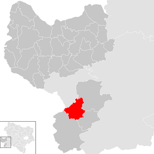
| Location of Opponitz in the Amstetten district | ||
  |
||
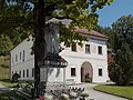
 Municipal Office |
||
| Source: Municipal data from Statistics Austria | ||

Opponitz is a municipality with 902 inhabitants (as of January 1, 2020) in the Amstetten district in Lower Austria . The main town of the municipality is the village of Hauslehen .
geography

Opponitz is located on the Ybbs in the Mostviertel in Eisenwurzen in Lower Austria . 72.52 percent of the municipality's area is forested.
The layered rock in the area is called the Opponitz Formation as a lithostratigraphic formation of the Upper Triassic of the Northern Limestone Alps.
Community structure
The municipality of Opponitz consists of the four cadastral municipalities :
- Ofenberg (2.31 km²)
- Opponitz (20.08 km²)
- Schwarzenbach (8.19 km²)
- Thann (9.08 km²)
The municipality includes the following seven localities (population in brackets as of January 1, 2020):
- Trench (76)
- Gstadt (66)
- Home Loans (462)
- Ofenberg (30)
- Schwarzenbach (69) including Rehau
- Strubb (41)
- Thann (158)
The main town of the municipality consists of the village of Opponitz (formerly Hauslehen ⊙ ) and the surrounding scattered settlement Hauslehen-strewn houses ( ⊙ ). The individual layers of Glatzreith, Hinterleithen, Oberpoint, Pichl and Vorderleithen also belong to this village .
Neighboring communities
| Waidhofen an der Ybbs (statute) | Ybbsitz | |
| Gaflenz ( Steyr-Land district , Upper Austria ) |
.svg)
|
|
| Hollenstein on the Ybbs | St. Georgen am Reith |
history
In ancient times, the area was part of the Noricum province . The place name Opponitz suggests an earlier Slavic settlement. The Slavic spelling is "sobot nica" and can be translated as "sound of water". The place is first mentioned in a Passau land register in 1256 as "Opotnitz".
Between 1922 and 1924, the Opponitz power plant was built by the City of Vienna in the Schwarzenbach district .
The Ybbstalbahn between Waidhofen an der Ybbs and Lunz am See was closed in 2011. The Ybbstal cycle path has been running on the former railway line since 2017.
Population development
According to the results of the 2001 census, there were 957 inhabitants. In 1991 the municipality had 1,031 inhabitants, in 1981 1,006 and in 1971 1,006 inhabitants.
Culture and sights

- Catholic parish church Opponitz hl. Kunigunde
Vicarage and war memorial

historical hammer mill "Hammer am Bach"


Economy and Infrastructure

In 2001 there were 30 non-agricultural workplaces, and according to the 1999 survey there were 67 in agriculture and forestry. According to the 2001 census, the number of people in employment at the place of residence was 430. In 2001 the employment rate was 46.18 percent. In 2003 there were an average of 786 unemployed.
- Opponitz is known to tourists as a fishing village and is particularly popular with fly fishermen .
traffic
- Train / bus: Opponitz was a station on the narrow-gauge Ybbstalbahn . Since September 4, 2010 the bus line MO1 has been running from Waidhofen via Opponitz to Hollenstein or to Lunz (if the weather permits, via the L98 (A), which means that the center of Opponitz can be reached directly and a relative saving in travel time compared to the closed narrow-gauge railway has been.)
politics
The municipal council has 15 members.
- With the municipal council elections in Lower Austria in 1990, the municipal council had the following distribution: 11 ÖVP and 8 SPÖ.
- With the municipal council elections in Lower Austria in 1995, the municipal council had the following distribution: 7 SPÖ, 6 ÖVP and 6 impartial citizens' list Opponitz-Aktiv.
- With the municipal council elections in Lower Austria in 2000, the municipal council had the following distribution: 11 ÖVP and 8 SPÖ. (19 members)
- With the municipal council elections in Lower Austria in 2005 , the municipal council had the following distribution: 8 ÖVP and 7 SPÖ.
- With the municipal elections in Lower Austria in 2010 , the municipal council had the following distribution: 8 ÖVP and 7 SPÖ.
- With the municipal elections in Lower Austria in 2015 , the municipal council has the following distribution: 10 ÖVP, 3 SPÖ and 2 FPÖ.
- With the municipal council elections in Lower Austria 2020 , the municipal council has the following distribution: 12 ÖVP, 2 SPÖ and 1 FPÖ.
mayor
- until 2010 Erwin Forster (Opponitz active)
- 2010–2014 Leopold Hofbauer (ÖVP)
- since 2014 Johann Lueger (ÖVP)
Personalities
Sons and daughters of the church
- Kurt Maier (1925-2016), politician (SPÖ)
- Reinhard Resch (* 1955), Austrian doctor, politician (SPÖ) and since 2012 mayor of Krems an der Donau
Web links
- Website of the municipality of Opponitz
- 30524 - Opponitz. Community data, Statistics Austria .
- Entry on Opponitz in the Austria Forum (in the AEIOU Austria Lexicon )
Individual evidence
- ↑ Statistics Austria: Population on January 1st, 2020 by locality (area status on January 1st, 2020) , ( CSV )
- ^ Municipality of Opponitz: History of Opponitz. In: Municipality of Opponitz. Retrieved February 4, 2020 .
- ↑ Press release on the start of the Mostviertel lines ; Retrieved January 18, 2012
- ^ Result of the local council election 1995 in Opponitz. Office of the Lower Austrian State Government, March 30, 2000, accessed on October 13, 2019 .
- ^ Election result of the municipal council election 2000 in Opponitz. Office of the Lower Austrian State Government, February 4, 2005, accessed on October 13, 2019 .
- ^ Election result of the local council election 2005 in Opponitz. Office of the Lower Austrian State Government, March 4, 2005, accessed on October 13, 2019 .
- ^ Election result of the municipal council election 2010 in Opponitz. Office of the Lower Austrian State Government, October 8, 2010, accessed on October 13, 2019 .
- ^ Election result of the 2015 municipal council election in Opponitz. Office of the Lower Austrian State Government, December 1, 2015, accessed on October 13, 2019 .
- ↑ Results of the municipal council election 2020 in Opponitz. Office of the Lower Austrian State Government, January 26, 2020, accessed on June 5, 2020 .

Allhartsberg | Amstetten | Ardagger | Aschbach Market | Behamberg | Biberbach | Ennsdorf | Ernsthofen | Ertl | Euratsfeld | Ferschnitz | Hague | Haidershofen | Hollenstein an der Ybbs | Kematen on the Ybbs | Neuhofen an der Ybbs | Neustadtl an der Donau | Oed-Oehling | Opponitz | Seitenstetten | Sonntagberg | St. Georgen am Reith | St. Georgen am Ybbsfelde | St. Pantaleon-Erla | St. Peter in der Au | St. Valentin | Strengberg | Viehdorf | Wallsee-Sindelburg | Weistrach | Winklarn | Wolfsbach | Ybbsitz | Zeillern
Cadastral municipalities: Ofenberg | Opponitz | Schwarzenbach | Thann
Locations: Graben | Gstadt | Home loan | Ofenberg | Schwarzenbach | Strubb | Thann
Village: Opponitz (house loan) | Scattered Houses: Graben · Gstadt · Hauslehen-Scattered Houses · Ofenberg · Schwarzenbach · Rehau · Strubb · Thann | Other locations: Garnberg · Mirenau (power station) · Seeburg Castle
Counting district: Opponitz