
Tajná: Difference between revisions
Content deleted Content added
m →Ethnicity: Disambiguation link repair - You can help! |
Goodmans238 (talk | contribs) Rescuing 5 sources and tagging 0 as dead.) #IABot (v2.0.9.5 |
||
| (27 intermediate revisions by 23 users not shown) | |||
| Line 1: | Line 1: | ||
{{Infobox settlement |
|||
[[Image:Okres nitra.png|thumb|right|300px|Nitra district in the Nitra region]] |
|||
| name = Tajná |
|||
'''Tajná''' is a [[village]] and [[municipality]] in the [[Nitra District]] in western central [[Slovakia]], in the [[Nitra Region]]. |
|||
| native_name = |
|||
| other_name = |
|||
| settlement_type = Municipality |
|||
<!-- images, nickname, motto --> |
|||
| image_skyline = |
|||
| image_caption = |
|||
| image_flag = |
|||
| image_shield = |
|||
| motto = |
|||
| nickname = |
|||
| etymology = |
|||
<!-- location --> |
|||
| subdivision_type = [[List of sovereign states|Country]] |
|||
| subdivision_name = {{SVK}} |
|||
| subdivision_type1 = |
|||
| subdivision_name1 = |
|||
| subdivision_type2 = [[Regions of Slovakia|Region]] |
|||
| subdivision_name2 = [[Nitra Region|Nitra]] |
|||
| subdivision_type3 = [[Districts of Slovakia|District]] |
|||
| subdivision_name3 = [[Nitra District|Nitra]] |
|||
| subdivision_type4 = |
|||
| subdivision_name4 = |
|||
<!-- maps and coordinates --> |
|||
| image_map = |
|||
| map_caption = |
|||
| pushpin_map = Slovakia Nitra Region#Slovakia |
|||
| pushpin_relief = 1 |
|||
| pushpin_map_caption = Location of Tajná in the [[Nitra Region]]##Location of Tajná in Slovakia |
|||
| coordinates = {{coord|48|16|N|18|22|E|display=inline,title}} |
|||
| coordinates_footnotes = |
|||
<!-- established --> |
|||
| established_title = First mentioned |
|||
| established_date = 1075 |
|||
<!-- area --> |
|||
| area_footnotes = |
|||
| area_total_km2 = 8.48<ref name="area">{{Cite web |url=http://datacube.statistics.sk/#!/view/sk/VBD_DEM/om7014rr/v_om7014rr_00_00_00_sk |title=Hustota obyvateľstva - obce [om7014rr_ukaz: Rozloha (Štvorcový meter)] |language=sk |date=2022-03-31 |website=www.statistics.sk |publisher=Statistical Office of the Slovak Republic |access-date=2022-03-31 |archive-date=2021-03-22 |archive-url=https://web.archive.org/web/20210322110600/http://datacube.statistics.sk/#!/view/sk/VBD_DEM/om7014rr/v_om7014rr_00_00_00_sk |url-status=live }}</ref> |
|||
| area_total_sq_mi = 3.27<ref name="area"/> |
|||
| area_land_sq_mi = |
|||
| area_water_sq_mi = |
|||
<!-- elevation --> |
|||
| elevation_footnotes = |
|||
| elevation_m = 162<ref name="base_info">{{Cite web |url=http://datacube.statistics.sk/#!/view/sk/VBD_SK_WIN/om5001rr/v_om5001rr_00_00_00_sk |title=Základná charakteristika |language=sk |date=2015-04-17 |website=www.statistics.sk |publisher=Statistical Office of the Slovak Republic |access-date=2022-03-31 |archive-date=2021-03-22 |archive-url=https://web.archive.org/web/20210322110600/http://datacube.statistics.sk/#!/view/sk/VBD_SK_WIN/om5001rr/v_om5001rr_00_00_00_sk |url-status=live }}</ref> |
|||
| elevation_ft = 531<ref name="base_info"/> |
|||
| population_as_of = {{abbr|2021|Population: 2021-12-31. Population density & Total area: 2021-06-30/-07-01. Elevation, Postal code & Area code (last updated): 2015-04-17.}} |
|||
| population_footnotes = |
|||
| population_total = 275<ref>{{Cite web |url=http://datacube.statistics.sk/#!/view/sk/VBD_DEM/om7101rr/v_om7101rr_00_00_00_sk |title=Počet obyvateľov podľa pohlavia - obce (ročne) |language=sk |date=2022-03-31 |website=www.statistics.sk |publisher=Statistical Office of the Slovak Republic |access-date=2022-03-31 |archive-date=2021-03-22 |archive-url=https://web.archive.org/web/20210322110600/http://datacube.statistics.sk/#!/view/sk/VBD_DEM/om7101rr/v_om7101rr_00_00_00_sk |url-status=live }}</ref> |
|||
| population_density_km2 = 32.42<ref name="pd">{{Cite web |url=http://datacube.statistics.sk/#!/view/sk/VBD_DEM/om7014rr/v_om7014rr_00_00_00_sk |title=Hustota obyvateľstva - obce |language=sk |date=2022-03-31 |website=www.statistics.sk |publisher=Statistical Office of the Slovak Republic |access-date=2022-03-31 |archive-date=2021-03-22 |archive-url=https://web.archive.org/web/20210322110600/http://datacube.statistics.sk/#!/view/sk/VBD_DEM/om7014rr/v_om7014rr_00_00_00_sk |url-status=live }}</ref> |
|||
| population_density_sq_mi= 12.52<ref name="pd"/> |
|||
| population_demonym = |
|||
<!-- time zone(s) --> |
|||
| timezone1 = [[Central European Time|CET]] |
|||
| utc_offset1 = +1 |
|||
| timezone1_DST = [[Central European Summer Time|CEST]] |
|||
| utc_offset1_DST = +2 |
|||
<!-- postal codes, area code --> |
|||
| postal_code_type = Postal code |
|||
| postal_code = 952 01<ref name="base_info"/> |
|||
| area_code_type = |
|||
| area_code = +421 37<ref name="base_info"/> |
|||
| geocode = |
|||
| iso_code = |
|||
| blank_name = [[Slovak car registration plates|Car plate]] |
|||
| blank_info = NR |
|||
<!-- website, footnotes --> |
|||
| website = {{url|tajna.sk}} |
|||
| footnotes = |
|||
}} |
|||
'''Tajná''' ({{lang-hu|Tajnasári}}) is a [[village]] and [[municipality]] in the [[Nitra District]] in western central [[Slovakia]], in the [[Nitra Region]].<ref>{{Cite web|url=http://en.e-obce.sk/obec/tajna/tajna.html|title=Tajná - Okres Nitra - E-OBCE.sk|access-date=2012-08-04|archive-date=2016-03-24|archive-url=https://web.archive.org/web/20160324114753/http://en.e-obce.sk/obec/tajna/tajna.html|url-status=live}}</ref> |
|||
==History== |
==History== |
||
In [[history|historical records]] the village was first mentioned in |
In [[history|historical records]] the village was first mentioned in 1075. |
||
==Geography== |
==Geography== |
||
The [[village]] lies at an [[altitude]] of 174 |
The [[village]] lies at an [[altitude]] of 174 metres and covers an [[area]] of 8.482 km<sup>2</sup>. It has a [[population]] of about 288 people. |
||
==Ethnicity== |
==Ethnicity== |
||
The population is about 98% [[Slovaks|Slovak]] and 2% [[Hungarian people|Magyar]]. |
The population is about 98% [[Slovaks|Slovak]] and 2% [[Hungarian people|Magyar]]. |
||
== Gallery == |
|||
<gallery> |
|||
File:Phoca thumb l jese 2012 - obec 018.jpg|alt=tajna_revay_manor_house|Révay's manor house |
|||
</gallery> |
|||
==References== |
|||
<references /> |
|||
==External links== |
==External links== |
||
* {{Commons category-inline|Tajná, Nitra District}} |
|||
* {{Official website}} |
|||
*http://www.statistics.sk/mosmis/eng/run.html |
*http://www.statistics.sk/mosmis/eng/run.html |
||
{{Nitra District}} |
{{Nitra District}} |
||
{{Authority control}} |
|||
{{DEFAULTSORT:Tajna}} |
|||
[[Category:Villages and municipalities in Nitra District]] |
[[Category:Villages and municipalities in Nitra District]] |
||
| ⚫ | |||
| ⚫ | |||
[[sk:Tajná]] |
|||
Latest revision as of 23:23, 27 April 2024
Tajná | |
|---|---|
Municipality | |
 Tajná Location of Tajná in the Nitra Region  Tajná Location of Tajná in Slovakia | |
| Coordinates: 48°16′N 18°22′E / 48.267°N 18.367°E | |
| Country | |
| Region | Nitra |
| District | Nitra |
| First mentioned | 1075 |
| Area | |
| • Total | 8.48[2] km2 (3.27[2] sq mi) |
| Elevation | 162[3] m (531[3] ft) |
| Population (2021) | |
| • Total | 275[1] |
| Time zone | UTC+1 (CET) |
| • Summer (DST) | UTC+2 (CEST) |
| Postal code | 952 01[3] |
| Area code | +421 37[3] |
| Car plate | NR |
| Website | tajna |
Tajná (Hungarian: Tajnasári) is a village and municipality in the Nitra District in western central Slovakia, in the Nitra Region.[5]
History[edit]
In historical records the village was first mentioned in 1075.
Geography[edit]
The village lies at an altitude of 174 metres and covers an area of 8.482 km2. It has a population of about 288 people.
Ethnicity[edit]
The population is about 98% Slovak and 2% Magyar.
Gallery[edit]
-
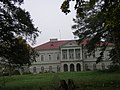 Révay's manor house

References[edit]
- ^ "Počet obyvateľov podľa pohlavia - obce (ročne)". www.statistics.sk (in Slovak). Statistical Office of the Slovak Republic. 2022-03-31. Archived from the original on 2021-03-22. Retrieved 2022-03-31.
- ^ a b "Hustota obyvateľstva - obce [om7014rr_ukaz: Rozloha (Štvorcový meter)]". www.statistics.sk (in Slovak). Statistical Office of the Slovak Republic. 2022-03-31. Archived from the original on 2021-03-22. Retrieved 2022-03-31.
- ^ a b c d "Základná charakteristika". www.statistics.sk (in Slovak). Statistical Office of the Slovak Republic. 2015-04-17. Archived from the original on 2021-03-22. Retrieved 2022-03-31.
- ^ a b "Hustota obyvateľstva - obce". www.statistics.sk (in Slovak). Statistical Office of the Slovak Republic. 2022-03-31. Archived from the original on 2021-03-22. Retrieved 2022-03-31.
- ^ "Tajná - Okres Nitra - E-OBCE.sk". Archived from the original on 2016-03-24. Retrieved 2012-08-04.
External links[edit]
 Media related to Tajná, Nitra District at Wikimedia Commons
- Official website

- http://www.statistics.sk/mosmis/eng/run.html
| International | |
|---|---|
| National | |
This Nitra Region geography article is a stub. You can help Wikipedia by expanding it. |