
Lendava
|
Lendava Lendva |
|||
|
|||
| Basic data | |||
|---|---|---|---|
| Country |
|
||
| Historic region | Übermurgebiet / Prekmurje | ||
| Statistical region | Pomurska (Mur region) | ||
| Coordinates | 46 ° 34 ' N , 16 ° 27' E | ||
| height | 160 m. i. J. | ||
| surface | 123.0 km² | ||
| Residents | 11,384 (2008) | ||
| Population density | 93 inhabitants per km² | ||
| Telephone code | (+386) 02 | ||
| Post Code | 9220 u. 9223 | ||
| License Plate | MS | ||
| Structure and administration | |||
| structure | 23 districts | ||
| Mayor : | Anton Balažek (independent) | ||
| Website | |||


Lendava , Hungarian Lendva (German: Unterlimbach ), is the easternmost municipality in Slovenia , in the Prekmurje region (German: Übermurgebiet ; Hungarian Muravidék ). The municipality borders Hungary in the east and Croatia in the south . Most of it belongs to the Slovene - Hungarian ethnically mixed area of Slovenia.
There is a city partnership with Zalaegerszeg in Hungary.
geography

population
The municipality of Lendava ( Slovene občina Lendava , Hungarian Lendva Község ) has 11,000 inhabitants, of which 52.2% are female and 47.8% male (December 31, 2005) . The average monthly income is € 979 gross or € 628 net (August 2003) . The village of Lendava itself has 3,400 inhabitants.
At the 2002 census, 90.2% of the municipality's inhabitants were Slovenian citizens, 6.3% Croatians , 1.1% EU citizens (then EU-15), 0.8% Yugoslavs (today: Serbs and Montenegrins ), 0 , 5% Bosnians , 0.3% Macedonians and 0.8% others.
46.8% of the population stated Slovene as their mother tongue and 42.1% Hungarian . Furthermore, according to their own information, 7.3% spoke Croatian , 0.9% Romani and 1.4% other languages. The official language is Slovenian and Hungarian in 20 of the 23 districts.
Districts
The municipality of Lendava comprises 23 districts (population figures from the 2002 census; sorted by postal location) :
- postal 9220 Lendava :
- Lendava (Hungarian: Alsólendva , German: Limbach ), pop. 3395, 160 m. i. J. , official languages: Slovenian a. Hungarian
- Petišovci (Hungarian Petesháza ), 843 inh ., 159 m , official languages: Slovene a. Hungarian
- Hotiza , 777 inh ., 165 m , official language: Slovenian
- Čentiba (Hungarian Csente , German Csente ), 756 inh ., 175 m , official languages: Slovene a. Hungarian
- Dolga vas (Hungarian Hosszúfalu , German: Niederdorf ), 621 inh., 162 m , official languages: Slovene a. Hungarian
- Lendavske Gorice (Hungarian Lendvahegy ), 586 inh ., 288 m , official languages: Slovene a. Hungarian
- Gaberje (Hungarian Gyertyános ), 539 inh ., 163 m , official languages: Slovenian a. Hungarian
- Kapca , 450 pop ., 164 m , official languages: Slovenian a. Hungarian
- Gornji Lakoš (Hungarian Felsőlakos , German: Ober Lakos ), 438 inh ., 162 m , official languages: Slovenian a. Hungarian
- Mostje (Hungarian: Hidvég , German: Sankt Hedwig ), 363 inh., 163 m , official languages: Slovenian a. Hungarian
- Dolina pri Lendavi (Hungarian Völgyifalu ), 343 inh ., 166 m , official languages: Slovene a. Hungarian
- Trimlini (Hungarian: Hármasmalom ), 330 inh ., 160 m , official languages: Slovenian a. Hungarian

- Dolgovaške Gorice (also Dolgovšgorice , Hungarian. Hosszúfaluhegy ), 277 inh ., 327 m , official languages: Slovene a. Hungarian
- Dolnji Lakoš (Hungarian Alsólakos , German: Nieder Lakos ), 243 inh ., 162 m , official languages: Slovenian a. Hungarian
- Pince , 205 inh., 164 m , official languages: Slovenian a. Hungarian
- Brezovec , 180 inh ., 287 m , official language: Slovenian
- Kot (Hungarian Kót ), 136 inh ., 164 m , official languages: Slovenian a. Hungarian
- Pince Marof (Hungarian Pincemajor ), 115 inh ., 156 m , official languages: Slovenian a. Hungarian
- Banuta (Hungarian: Bánuta ), 75 inh ., 163 m , official languages: Slovenian a. Hungarian
- Benica , 75 inh ., 156 m , official language: Slovenian
- postal 9223 Dobrovnik (German: Dobronack ):
- Radmožanci (Hungarian Radamos ), 254 inh ., 166 m , official languages: Slovenian a. Hungarian
- Genterovci (Hungarian: Göntérháza , German: Gänsdorf ), 206 inh ., 164 m , official languages: Slovenian a. Hungarian
- Kamovci (Hungarian: Kámaháza ), 113 pop ., 164 m , official languages: Slovenian a. Hungarian
history
The then Alsólendva was until 1918 the administrative seat of the eponymous chair district (Hungarian járás ) in the Hungarian county of Zala . The capital of the county was Zalaegerszeg , which is now a twin town of Lendava. After the collapse of Austria-Hungary , the so-called Mur Island (the area around Lendava and today's Croatian Međimurje County ) was occupied in 1919 by troops from the newly established Kingdom of Serbs, Croats and Slovenes . The Treaty of Trianon in 1920 denied Hungary the area and thus prevented attempts by the population to reintegrate.
politics
The current mayor is Anton Balažek . It is his second term that will end in 2011. Balažek won the last election with his own list and with the support of left-wing liberal parties.
The cooperation center of the Austrian police Dolga Vas is located in Lendava .
Attractions
- Synagogue , built in 1866
- Jewish cemetery , built in 1850
Infrastructure
education
There are 2 primary schools in Lendava, one of which is handicapped accessible. The Lendava Middle School (DSS) was founded in 1903. In 1945 and in the post-war period, the school's program was expanded, including a. about technical directions. Later I also trained as a retail salesman and went to high school. Since 1981, the school has offered lessons in both Slovenian and Hungarian. In 2005 a new, more modern school building was built, which consists of 25 classrooms, a workshop, a gym and a sports field.
traffic
Lendava has been connected to the A5 motorway ( Maribor - Nagykanizsa ) since 2008 .
There is also a freight yard. Passenger traffic to Čakovec (Croatia) was resumed when the timetable changed at the end of 2014. There are two pairs of trains running on Saturdays.
economy
At Lendava cause major oil - and gas - pipelines over. This also led to the operation of the Nafta Lendava Group's former refinery until the end of the 1980s . After the break-up of Yugoslavia , the group got into financial difficulties. The refinery was sold to a Chinese company; The factories for methanol and adhesives have remained . After years of restructuring, the NAFTA group was divided into 6 subsidiaries and these in turn were all nationalized . In the last few years the inquiries from potential - mostly Russian - buyers of some subsidiaries have increased.
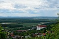
View over Lendava into the Mur plain
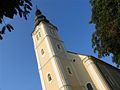
The Lendava Church

The abandoned Jewish cemetery in Lendava
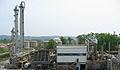
The Nafta Lendava Group's methanol factory

The bilingual middle school in Lendava (DSS)


Web links
- Official homepage of the municipality
- Homepage of the bilingual secondary school in Lendava (DSS)
- Lendava on 24cities.eu, Competence Center Steirisches Thermenland -Oststeiermark
Individual evidence
- ↑ Statistical Office of the Republic of Slovenia (1.4% other languages = 0.4% Serbian , 0.3% Serbo-Croatian , 0.3% Albanian , 0.1% Bosnian , 0.1% German , 0.2% other; 1.6% did not provide any information)
- ↑ a b c d e f Lumtzer, Viktor / Melich, Johann; German place names and loan words from the Hungarian vocabulary. Sources and research on the history, literature and language of Austria and its crown lands; Publishing house of the Wagner University Bookstore Innsbruck, 1900.
- ^ Police cooperation center Dolga Vas in the directory of the Austrian Ministry of the Interior, accessed on January 19, 2016
Apače · Beltinci · Cankova · Črenšovci · Dobrovnik / Dobronak · Gornja Radgona · Gornji Petrovci · degree · Hodoš / Hodos · Kobilje · Križevci · Kuzma · Lendava / Lendva · Ljutomer · Moravske Toplice / Alsómarác · Murska Sobota · Odranci · Puconci · Radenci · Razkrižje · Rogašovci · Šalovci / Sal · Sveti Jurij · Tišina · Turnišče · Velika Polana · Veržej