Bélesta (Ariège)
|
Bélesta Belestar |
||
|---|---|---|

|
|
|
| region | Occitania | |
| Department | Ariège | |
| Arrondissement | Pamiers | |
| Canton | Pays d'Olmes | |
| Community association | Pays d'Olmes | |
| Coordinates | 42 ° 54 ′ N , 1 ° 56 ′ E | |
| height | 475-1,082 m | |
| surface | 26.94 km 2 | |
| Residents | 1,064 (January 1, 2017) | |
| Population density | 39 inhabitants / km 2 | |
| Post Code | 09300 | |
| INSEE code | 09047 | |
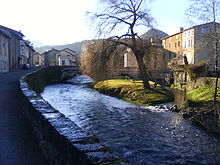
 Bélesta - the townscape |
||
Bélesta ( Occitan Belestar or Balhestár ) is a place and a municipality with 1,064 inhabitants (as of January 1, 2017) in France . It is located in the Ariège department in the Occitanie region (previously Midi-Pyrénées ). The name Bélesta (originally Bellostare ) means something like 'nice stay'.
location
The municipality of Bélesta is located in the Hers-Vif valley at the foot of the French Pyrenees, about 46 kilometers (driving distance) northeast of Ax-les-Thermes and about 27 kilometers south of Mirepoix . Neighboring municipalities are Lesparrou , Rivel , Roquefeuil , Fougax-et-Barrineuf and L'Aiguillon .
Population development
| year | 1962 | 1968 | 1975 | 1982 | 1990 | 1999 | 2006 | 2017 |
| Residents | 1395 | 1330 | 1441 | 1386 | 1337 | 1179 | 1114 | 1064 |
In the 19th century the community always had between 1,800 and 2,700 inhabitants. The phylloxera crisis in viticulture and the mechanization of agriculture led to a loss of jobs in the 20th century and thus to a drop in the number of inhabitants to the lows of recent decades.
economy
For centuries, the residents of the village lived on self-sufficient farming and livestock. The small-scale viticulture in the municipality also came to a complete standstill at the end of the 19th century, and red, rosé and white wines are now being produced again, which are marketed through the Comté Tolosan and Ariège appellations. Many vacant houses have been converted into holiday apartments ( gîtes ).
history
Early history
In the area of the municipality, the first traces of settlement were found in the surrounding karst caves from the end of the Paleolithic . The Oppidum du Mayne , above the Fontaine de Fontestorbes, dates from (presumably) Celtic times . Archaeologists date the finds to the 3rd to 1st century BC. Chr.
middle Ages
A first castle already existed before the crusade against the Albigensians ( beginning in 1209 ). It belonged to the de Bellissen family , who in the Treaty of Paris in 1229 had to cede all goods to Guy de Lévis , a colleague of Simon IV. De Montforts . The so-called Château de la ville was built towards the end of the 13th century . In 1320 the Saigneurie Bélesta came into the possession of the de Lévis-Léran family by dividing up the county of Mirepoix . A fire destroyed large parts of Bélesta in 1510.
Huguenot Wars

In 1522 Protestants from Léran destroyed the church in Val d'Amour. In the middle of the 16th century, Bélesta became an independent county through inheritance. In 1550, Jean-Claude de Lévis-Léran, Count of Audan and Bélesta, built the Château d'Amount . In the following years he headed the regional Huguenots , banned Catholicism in the county between 1559 and 1599 and had the Saint-Blaise church converted into a reformed church. In 1674 the Château d'Amount is only a ruin.
Since the French Revolution
During the French Revolution in 1794, Bélesta briefly became the capital of a canton to which the municipalities of Fougax, Barrineuf, l'Aiguillon and Vilhac belonged. But as early as 1804 the canton was dissolved and the municipalities incorporated into the canton of Lavelanet . On June 23, 1802, a flood of the Hers-Vif destroyed large parts of the village.
Culture and sights
Natural monuments
- Gorges de la Frau : imposing gorge of the Hers between Comus and Bélesta
- Forêt de Bélesta : The forest of Bélesta supplied the wood for the masts of the Louis XIV fleet .
- Fontaine de Fontestorbes : The intermittent spring is located approx. 500 meters east of the village.
- Gouffre des Corbeaux : At an altitude of 850 m in the middle of the forest there is a 60 by 30 meters large and 110 meters deep hole.
Buildings
- Castel d'Amount : built in 1550, destroyed during the Huguenot Wars . Today only ruins remain.
- Château de Péchafilou : built in the 15th century, restored in the 18th century
- Notre-Dame-du-Val-d'Amour : Church from the 14th century, restored in the 17th century and 1824.
Museums
- The Museum of Early History
Web links
- Belesta, Viticulture - Info (French)
