Fallow
|
Fallow
City of Hückelhoven
|
|
|---|---|
| Coordinates: 51 ° 0 ′ 12 ″ N , 6 ° 14 ′ 27 ″ E | |
| Height : | 62 m |
| Area : | 12.4 km² |
| Residents : | 3402 (June 30, 2014) |
| Population density : | 274 inhabitants / km² |
| Incorporation : | January 1, 1972 |
| Postal code : | 41836 |
| Area code : | 02462 |
|
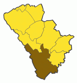
Hückelhoven city area, area of the former municipality of Brachelen highlighted
|
|
Brachelen is a district of Hückelhoven in the North Rhine-Westphalian district of Heinsberg .
geography
location
Brachelen is located in the south of the Heinsberg district on the left bank of the Rur between the villages of Hilfarth , Lindern and Linnich . The hamlets Tenholt and Oeldriesch as well as the Gut Wedau and Schlehenhof farms are in the catchment area of the village. The rest of the Kapbusch is located between Brachelen and Hilfarth , an extensive forest area in the left Rur valley between Brachelen and Porselen at the beginning of the 19th century , where the last wolf in the area of the old Selfkant district of Geilenkirchen-Heinsberg was captured in 1834.
Waters
- The Teichbach , a mill pond derived from the Rur south of Linnich , runs along the eastern edge of the village.
- The ' Badesee Kapbusch ' near Brachelen, a former quarry pond , is the only outdoor swimming pool in the city of Hückelhoven.
history
Political history
The first settlement probably took place as early as the time of the Great Migration around 400 AD. The origin of the place is assumed to be a Franconian royal estate, which is said to have stood above today's church.
Brachelen was first mentioned in a document in a donation from Oda von Heinsberg in 1170 to the Premonstratensian Abbey of Heinsberg.
The place name was first mentioned as Brakele in 1204. It is explained as a combination of Bracha for wrapped land and Lohe for a settlement near the forest. A second variant of interpretation seeks to derive the first part of the place name from Brok , the Ripurarian term for break .
In 1484 Brachelen fell to the Duchy of Jülich and was incorporated into the Office of Heinsberg.
In 1793 the Rur near Brachelen was the main battle line of the First Coalition War for days . Here, units of the French revolutionary army advancing towards the Rhine after the cannonade of Valmy encountered Austrian troops . During the fighting, the 300-strong Third was Paris battalion under General stalks of two Austrian cavalry - squadrons completely wiped out - but what the French advance to Mainz and Koblenz did not prevent.
The mayor's office in Brachelen was established in 1815, and in 1935 it was merged with the mayor's office in Randerath to form the Brachelen office and in 1955 it was given its own coat of arms . Brachelen was in the Selfkant district of Geilenkirchen-Heinsberg. In the course of the local reorganization , Brachelen became part of the new town of Hückelhoven in the Heinsberg district on January 1, 1972.
Social history
The nearby Kapbusch served the so-called Kappehuern in the form of logging as a source of income. The Kappehäuer a monument in the form of a was bronze sculpture , located in the village set. Another important occupation were the basket makers , who obtained their work material, the basket willows , from the Rurbenden.
religion
The majority of the population is Catholic , but Protestants , Muslims and atheists also live in the village. However, there is only one Catholic church in the village. The parish of St. Gereon used to include Hilfarth and Lindern; today the parishes of Brachelen, Hilfarth and Rurich form a community. Pastor Kaluppilankal, who was born in India, was a parish priest until the end of 2014.
Village type
The original local form of Brachelens was a single-line elongated street village , which can still be seen today in the arrangement of the streets Annastraße , Hauptstraße and Linnicher Straße . This structure was broken up by further settlements, mainly on the western edge of the village.
politics
mayor
The last mayor of Brachelen until 1972 was Wilhelm Over , who as a member of the Hückelhoven city council and founder of the company was still able to achieve a lot for the development of the place.
coat of arms
The coat of arms of Brachelen shows a striding, red-tongued, black lion in the shield head in gold (yellow), and underneath in red an acorn with a gold ribbon.
Culture and sights
Buildings
- The church is first mentioned in a document in 1245, but a small wooden church already existed in Franconian times. Until 1944 it consisted of a Gothic three-aisled building with a 73 m high tower , which was blown up by the Wehrmacht during World War II so that it could not serve as a lookout tower or landmark for the enemy. After the reconstruction in 1963, the church tower lost a third of its original height and the nave had to be rebuilt. Only the choir has been preserved in its original form.
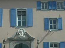
- A two-story manor house from the 16th century and the adjoining, also two-story hall building with a baroque portal from the 17th century have been preserved from the former knight's seat.
- House Horrig
- House mountain
- The former monastery complex was expanded into an old people's and nursing home.
- Anna Chapel
- The Anna Chapel is a neo-Gothic building from 1864 in the north of the lower village.
- Maria-Hilf-Chapel (located approximately in the center of the village)
leisure
The place has a swimming lake, a youth campground, riding stables and developed cycle paths along the Teichbach and the Rur.
Economy and Infrastructure
traffic
Brachelen stop
Brachelen is connected to the Aachen – Mönchengladbach railway line via the Brachelen stop and is served by the Rhein-Niers-Bahn .
On October 1, 1904, the Brachelen stop was opened with a small half-timbered station building. As early as 1910, the stop was completely rebuilt, the track system expanded and goods handling started in the following year. At the Brachelen stop, three additional sidings were now available in addition to the main tracks. The goods handling facility was located opposite the small station building on the northern track.
After 1970, the breakpoint was dismantled until only the two main tracks remained. Before that there was still regular freight traffic to Brachelen. Today only the street Am Güterbahnhof reminds of it.
Until the breakpoint was completely renovated in 2004, only a single-storey station building was left.
| line | Train run | Clock frequency |
|---|---|---|
| RB 33 |
Rhein-Niers-Bahn : Essen Hbf - Mülheim (Ruhr) Hbf - Mülheim (Ruhr) -Styrum - Duisburg Hbf - Duisburg-Hochfeld Süd - Rheinhausen Ost - Rheinhausen - Krefeld-Hohenbudberg Chempark - Krefeld-Uerdingen - Krefeld-Linn - Krefeld- Oppum - Krefeld Hbf - Forsthaus - Anrath - Viersen - Mönchengladbach Hbf - Rheydt Hbf - Wickrath - Herrath - Erkelenz - Hückelhoven-Baal - Brachelen - Lindern - Geilenkirchen - Übach-Palenberg - Herzogenrath - Kohlscheid - Aachen West - Aachen Schanz - Aachen Hbf Stand : Timetable change December 2019 |
60 min |
Transportation
Brachelen is served by bus route 406:
| line | course |
|---|---|
| 406 | Erkelenz Bf - Matzerath - Houverath - Golkrath - Kleingladbach - ( Ratheim - Millich -) Hückelhoven - Hilfarth - Brachelen - ( Lindern Bf -) Linnich SIG Combibloc |
Road traffic
Brachelen has a connection to the A 46 via the Hückelhoven-Ost junction and to the B 57 near Linnich.
sons and daughters of the town
- Jörg Beyel (* 1969), former professional footballer
- Alina Bock (* 1984), member of the band beFour
- Oliver Schmidt (* 1972), sports presenter
- Heinz Schüngeler (1884–1949) music teacher, pianist and composer
Web links
- Website of the city of Hückelhoven
- Monuments in the city of Hückelhoven
- Churches and chapels in the city of Hückelhoven
- Article on local history
- Brachelen station on gessen.de
Individual evidence
- ↑ Tranchot map (between 1801 and 1828) regarding the forest called Kapper Wald at the time
- ↑ Dr. Wilhelm Piepers, Hans E. Wolters, Werner Reinartz, Balthasar Jacobs, Heinrich Bast, Josef Schmitz: Our home, the Selfkantkreis Geilenkirchen Heinsberg . Published by the working group of home nurses of the Heinsberg district, Gatzen book printing company, Geilenkirchen 1956, p. 119
- ↑ Dr. Wilhelm Piepers, Hans E. Wolters, Werner Reinartz, Balthasar Jacobs, Heinrich Bast, Josef Schmitz: Our home, the Selfkantkreis Geilenkirchen Heinsberg . Published by the working group of home nurses of the Heinsberg district, Gatzen book printing company, Geilenkirchen 1956, p. 21
- ↑ Dr. Wilhelm Piepers, Hans E. Wolters, Werner Reinartz, Balthasar Jacobs, Heinrich Bast, Josef Schmitz: Our home, the Selfkantkreis Geilenkirchen Heinsberg . Published by the working group of home nurses of the Heinsberg district, Gatzen book printing company, Geilenkirchen 1956, p. 21
- ^ Federal Statistical Office (ed.): Historical municipality directory for the Federal Republic of Germany. Name, border and key number changes in municipalities, counties and administrative districts from May 27, 1970 to December 31, 1982 . W. Kohlhammer, Stuttgart / Mainz 1983, ISBN 3-17-003263-1 , p. 307 .
- ↑ (Source: " The French Revolution in Eyewitness Reports ", Munich 1976 - pp. 333–335)


