
Bremgarten district
| Bremgarten district | |
|---|---|
 |
|
| Basic data | |
| Country: |
|
| Canton : |
|
| Main town : | Bremgarten |
| FSO number : | 1903 |
| Area : | 117.47 km² |
| Height range : | 346–741 m above sea level M. |
| Residents: | 78,080 (December 31, 2019) |
| Population density : | 665 inhabitants per km² |
| map | |
 |
|

| Seats in the Grand Council (2016-2020) |
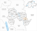
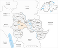
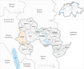
The Bremgarten district is a district in the canton of Aargau in Switzerland , which essentially consists of the northern Freiamt in the Reuss and Bünztal valleys . The district comprises 22 municipalities (as of January 1, 2014).
Municipalities
| coat of arms | Name of the parish | Population (December 31, 2019) |
Area in km² |
Inhabitant per km² |
|---|---|---|---|---|
|
|
Arni (AG) | 1870 | 3.37 | 555 |
|
|
Berikon | 4757 | 5.38 | 884 |
|
|
Bremgarten (AG) | 8218 | 11.36 | 723 |
|
|
Buettikon | 975 | 2.82 | 346 |
|
|
Dottikon | 3885 | 3.88 | 1001 |
|
|
Eggenwil | 1038 | 2.46 | 422 |
|
|
Fischbach-Göslikon | 1616 | 3.07 | 526 |
|
|
Hagglingen | 2441 | 7.75 | 315 |
|
|
Islisberg | 630 | 1.66 | 380 |
|
|
Jonen | 2181 | 5.70 | 383 |
|
|
Niederwil (AG) | 2818 | 6.15 | 458 |
|
|
Oberlunkhofen | 2039 | 3.25 | 627 |
|
|
Oberwil-Lieli | 2459 | 5.35 | 460 |
|
|
Rudolfstetten-Friedlisberg | 4520 | 4.90 | 922 |
|
|
Sarmenstorf | 2932 | 8.30 | 353 |
|
|
Daytime | 1489 | 3.29 | 453 |
|
|
Uezwil | 491 | 2.44 | 201 |
|
|
Unterlunkhofen | 1470 | 4.49 | 327 |
|
|
Villmergen | 7436 | 11.94 | 623 |
|
|
Widen | 3773 | 2.62 | 1440 |
|
|
Well | 16,541 | 12.48 | 1325 |
|
|
Zufikon | 4501 | 4.81 | 936 |
| Total (22) | 78,080 | 117.47 | 665 | |
Changes in the community

Municipalities until 1900
Municipalities until 1908
Municipalities until 1913

Municipalities until 1952

Municipalities until 1982

Municipalities until 1983
Municipalities until 2009

Municipalities until 2013


- 1803: Separation from Büttikon → Hilfikon
- 1803: Separation from Eggenwil → Widen
- 1803: Merger of Arni and Islisberg → Arni-Islisberg
- 1901: Merger of Nesselnbach and Niederwil → Niederwil
- 1909: Lieli and Oberwil → Oberwil merge
- 1914: Merger of Anglikon and Wohlen → Wohlen
- 1953: Change of name from Hermetschwil → Hermetschwil-Staffeln
- 1953: Name change from Rudolfstetten → Rudolfstetten-Friedlisberg
- 1983: Split from Arni-Islisberg → Split into the municipalities of Arni and Islisberg
- 1984: Name change from Oberwil → Oberwil-Lieli
- 2010: Fusion of Hilfikon and Villmergen → Villmergen
- 2014: Merger of Bremgarten and Hermetschwil-Staffeln → Bremgarten
Localities
| Postcode | Name of the place | local community |
|---|---|---|
| 8965 | Ober-Berikon | Berikon |
| 8965 | Unter-Berikon | Berikon |
| 5626 | Hermetschwil | Bremgarten |
| 5626 | Seasons | Bremgarten |
| 5607 | Hedgehog pasture | Hagglingen |
| Rüti | Hagglingen | |
| Rüti Höfe (formerly Ämet) | Hagglingen | |
| Litzi | Jonen | |
| Grumble | Jonen | |
| Whipping | Jonen | |
| Gnadenthal | Niederwil | |
| Nesselnbach | Niederwil | |
| 8966 | Lieli | Oberwil-Lieli |
| 8966 | Oberwil | Oberwil-Lieli |
| 8964 | Friedlisberg | Rudolfstetten-Friedlisberg |
| 8964 | Rudolfstetten | Rudolfstetten-Friedlisberg |
| 5522 | Büschikon | Daytime |
| Huserhof | Unterlunkhofen | |
| 5613 | Hilfikon | Villmergen |
| 8967 | Hasenberg | Widen |
| 5611 | Anglicon | Well |
| 5621 | Oberdorf | Zufikon |
| 5621 | Unterdorf | Zufikon |
Web links
Individual evidence
- ↑ Cantonal population statistics 2019. Department of Finance and Resources, Statistics Aargau, March 30, 2020, accessed on April 2, 2019 .
- ↑ Results of the Grand Council elections 2016. State Chancellery of the Canton of Aargau, accessed on July 27, 2020 .
- ↑ Federal Statistical Office Generalized Limits 2020.
Arni * | Berikon | Bremgarten | Büttikon | Dottikon | Eggenwil | Fischbach-Göslikon | Hagglingen | Islisberg * | Jonen | Niederwil | Oberlunkhofen | Oberwil-Lieli | Rudolfstetten-Friedlisberg * | Sarmenstorf | Daily | Uezwil | Unterlunkhofen | Villmergen | Widen * | Wohlen | Zufikon
* This municipality does not own any objects of the categories A or B, but can have (currently undocumented) C objects.