Buchholz (Duisburg)
|
|||
|---|---|---|---|
| map | |||

|
|||
| Basic data | |||
| Coordinates : | 51 ° 22 '43 " N , 6 ° 45' 56" E | ||
| Area : | 3.52 km² | ||
| Postal code : | 47249 | ||
| Area code : | 0203 | ||
| population | |||
| Residents : | 13,948 (Dec. 31, 2017) | ||
| Population density : | 3963 inhabitants / km² | ||
| Proportion of foreigners : | 6.78% (946) | ||
| structure | |||
| District : | Duisburg-South | ||
| District number: | 703 | ||
| Incorporation : | August 1, 1929 | ||
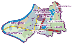
Buchholz in a Duisburg district in the Duisburg-Süd district . 13,948 people live in the district on an area of 3.52 km² (as of December 31, 2017).
history
Buchholz emerged from individual farmsteads in the area of the Huckinger Gemarkenwald, which mainly consisted of beeches and was part of the old Duisburg Reichswald. The Buchholzer Mark bordered in the north on the forest belonging to Duisburg, in the west on the Rhine (Eichelskamp) and on the Klevian enclave of Wanheim-Angerhausen . The oldest surviving wisdom on the border towards the Klevian side dates back to 1489. Up until the 15th century there was only one farm in the area, the Kirchmannshof in the east of Buchholz, which was demolished in 1961/62. The place Buchholz can be spoken of from 1830. With the clearing of part of the forest from 1820 onwards, arable land was created for agricultural use and settlement. Only the beech forest on Wedauer Straße and parts of the area that has included the Duisburg Forest Cemetery (known at times as the New Cemetery ) since 1923 are all that remains of the original forest .
With the rapidly growing population at the end of the 19th century, the establishment of a separate parish became necessary. Until 1910 the mother parish of Bucholz was the Catholic parish of St. Peter and Paul in Huckingen. It was not until 1900 that a parish rectorate was set up in Buchholz, which was elevated to a parish in 1910. In the same year the first service took place in the new Buchholz parish church with the name of the apostle Judas Thaddäus. Before that, a small emergency church had existed since 1900. The Protestant residents attended church services in Wanheim-Angerhausen and, since 1923, in Wedau .
The first school on Schulstrasse, today Münchener Strasse, was inaugurated on August 18, 1868. The first students were 48 boys and 50 girls. In 1914 there were already 1,016 students in 17 classes. When the French occupied the Ruhr area in 1921, the school was occupied by French troops. In 1929 Buchholz left the Düsseldorf district and was incorporated into the Duisburg district.
Population development
Since 1895 the population has developed as follows:
| year | population |
|---|---|
| 1895 | 887 |
| 1925 | 4,505 |
| 1930 | 4,441 |
| 1939 | 7,505 |
| 1962 | 20,098 |
| 2013 | 14,037 |
| 2014 | 14,073 |
| 2015 | 13,909 |
| 2016 | 14,000 |
| 2017 | 13,948 |
Infrastructure
Public facilities
The BG Klinikum Duisburg , which specializes in trauma surgery (supra-regional trauma center ), spinal cord injuries, hand surgery, septic surgery, burn injuries and pain medicine and is also the location of the rescue helicopter Christoph 9, is located on Großenbaumer Allee .
The Buchholz district library is located on Sittardsberger Allee. It holds around 23,000 media.
Since September 2010, the Sittardsberg Health Center (GZS) has been right next door with numerous different doctor and therapy practices, wellness and fitness offers.
Other facilities
The headquarters of Kindernothilfe , one of the world's largest Christian aid organizations, is in Duisburg-Buchholz .
traffic
Buchholz has a connection to the A 59 , which used to end in Buchholz when coming from the north. As a result, the ascent is only possible in the north and the exit only from this direction. The motorway was later extended to the south. In the meantime, at the Duisburg-Süd motorway junction, it merges with the B 8n leading to Düsseldorf . During the expansion, however, no additional entrances or exits were created in Buchholz, so that the motorway connection in Großenbaum can be used from the south or to the south .
In addition, Buchholz is connected to Duisburg city center via the S-Bahn line 1 and the U-Bahn line 79 . Several bus routes connect Buchholz with other parts of the city.
| line | Line designation | Line course |
|---|---|---|
| S 1 | Rhine-Ruhr S-Bahn | Dortmund - Bochum - Essen - Mülheim (Ruhr) - Duisburg - Düsseldorf Airport - Düsseldorf - Hilden - Solingen |
|
←
|
Lines |
→
|
||
|---|---|---|---|---|
| Duisburg-Großenbaum |
Cologne – Duisburg |
Duisburg-Schlenk | ||
Personalities
- Torsten Toeller (* 1966), founder of Fressnapf , lives in Buchholz
- Moritz Stoppelkamp (* 1986), professional soccer player, began his career in Buchholz
Web links
literature
- Günter von Roden: History of the City of Duisburg , Volume 2, Duisburg 1974, pp. 284–286.
Individual evidence
- ↑ a b PDF, population statistics of the city of Duisburg from December 31, 2017 (PDF; 21 kB)
- ↑ Roden (1974), p. 284 f.
- ↑ An old photo of the Kirchmannshof can be found at Martin Ahlers: The exciting Boerakker saga , in: WAZ Online from September 16, 2014 ( online ).
- ↑ Roden (1974), p. 285.
- ↑ Roden (1974), p. 285 f.
- ↑ Roden (1974), p. 285.
- ↑ Burn injuries. Employer's Liability Insurance Association Duisburg , accessed on September 18, 2014 .
- ↑ https://www.waz.de/staedte/duisburg/kinderothilfe-baut-ihren-hauptsitz-in-duisburg-aus-id6956974.html
