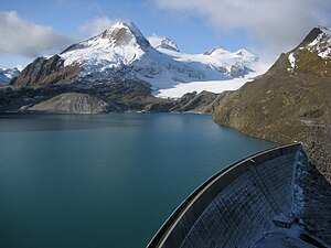
Griessee (Switzerland)
| Griessee | |||||||||
|---|---|---|---|---|---|---|---|---|---|
|
|||||||||
|
|
|||||||||
| Coordinates | 671551 / 145554 | ||||||||
| Data on the structure | |||||||||
| Lock type: | Gravity dam | ||||||||
| Construction time: | 1963-1966 | ||||||||
| Height of the barrier structure : | 60 m | ||||||||
| Height above the river bed : | 66 m | ||||||||
| Height of the structure crown: | 2387.5 m above sea level M. | ||||||||
| Building volume: | 251 000 m³ | ||||||||
| Crown length: | 400 m | ||||||||
| Slope slope on the air side : | from bottom to top: 1: 0.85 1: 0.72 1: 0.68 1: 0.25 |
||||||||
| Slope slope on the water side : | perpendicular | ||||||||
| Power plant output: | 1st level: Altstafel 9.2 MW 2nd level: Bavona 3rd level: Cavergno 4th level: Verbano |
||||||||
| Operator: |
Kraftwerk Aegina AG owned by: - Rhonewerke AG: 50% - OFIMA : 50% |
||||||||
| Data on the reservoir | |||||||||
| Altitude (at congestion destination ) | 2386.3 | ||||||||
| Water surface | 59.4 ha | ||||||||
| Reservoir length | 1.2 km | ||||||||
| Reservoir width | 700 m | ||||||||
| Maximum depth | 66 m | ||||||||
| Storage space | 18 million m³ | ||||||||
| Total storage space : | 18.6 million m³ | ||||||||
| Catchment area | 10.5 km² | ||||||||
| Design flood : | 38.8 m³ / s | ||||||||
The Griessee in the canton of Valais is one of the highest reservoirs in Switzerland. The reservoir is used for power generation by the Aegina AG power plant .
location
The lake is located in the area of the once independent municipality of Ulrichen , which today belongs to the municipality of Obergoms . It is fed by the Gries glacier , the natural outflow of the lake is the Mändelibach, whose water flows over the Griesseebach and the Ägene near Ulrichen into the Rhone .
The reservoir can be reached via the Nufenenpassstrasse . From the west ramp, an approx. 2 km long mountain road leads south to the reservoir. In the south, a mule track leads over the Gries Pass to Italy . In addition to the Griessee, the first turbine at the Gries wind farm was put into operation in 2011 .
use
After a construction period of three years, the Gries dam was completed in 1966. The lake water is of AG Kraftwerk Aegina used that in half the Rhone works and in half the Maggia power plants belongs It operates the underground power station Altstafel ▼ , which has an output of 9.2 MW and 21.6 million kWh of energy feeding into the grid annually . Almost 80% of the energy is generated in the winter half-year. The control center is accessed from the equipment chamber at the base of the dam via an inclined elevator .
The underwater from Altstafel is led through a tunnel under the canton border into the canton of Ticino , where it is further used by Maggia Kraftwerke AG . First it reaches the Lago di Robièi ▼ , then it is used by three other centers as far as Lake Maggiore , namely those of Bavona ▼ , Cavergno ▼ and Verbano ▼ near Brissago .
The high usable gradient between the reservoir at 2387.5 m above sea level. M. and the Langensee at 194 m above sea level. M. leads to the fact that the water in the Griessee has a very high value for electricity generation. The 18 million m³ storage capacity can do 15 million kWh of work in Altstafel and a further 63 million kWh in the machine houses of the Maggia power plants on the way to the valley, which results in a total of 78 million kWh. That means one cubic meter of Griessee water can produce 4.3 kWh on the way down into the valley, which is one of the highest energy equivalents in Switzerland.
swell
- Lakes in Switzerland: Natural and storage lakes, Federal Office for the Environment FOEN, 2007 ( Memento from October 5, 2008 in the Internet Archive ) → Lakes in Switzerland (PDF)
- Website Maggia Kraftwerke AG
Web links
- Griessee (Switzerland) on the ETHorama platform
- Andrea Baumer: Gries . Ed .: Swiss Dam Committee. ( swissdams.ch [PDF]).
Individual evidence
- ↑ a b EnAlpin AG - Kraftwerk Aegina AG. Retrieved June 8, 2020 .
- ↑ a b Geoserver of the Swiss Federal Administration ( information )
- ↑ 3988.01 Altstafel power plant cavern center - Griessee dam base. In: standseilbahnen.ch. Retrieved June 8, 2020 .
- ^ Officine Idroelettriche della Maggia SA. Retrieved June 6, 2020 (Official Website).
- ↑ Andrea Baumer: Gries . Ed .: Swiss Dam Committee. ( swissdams.ch [PDF]).

