
Harmsdorf (Ostholstein)
| coat of arms | Germany map | |
|---|---|---|

|
Coordinates: 54 ° 14 ' N , 10 ° 50' E |
|
| Basic data | ||
| State : | Schleswig-Holstein | |
| Circle : | Ostholstein | |
| Office : | Lensahn | |
| Height : | 56 m above sea level NHN | |
| Area : | 17.82 km 2 | |
| Residents: | 651 (Dec. 31, 2019) | |
| Population density : | 37 inhabitants per km 2 | |
| Postal code : | 23738 | |
| Area code : | 04363 | |
| License plate : | OH | |
| Community key : | 01 0 55 020 | |
| Office administration address: | Eutiner Strasse 2 23738 Lensahn |
|
| Website : | ||
| Mayor : | Reinhard Schöning ( CDU ) | |
| Location of the community Harmsdorf in the Ostholstein district | ||
  |
||

Harmsdorf is a municipality in the Ostholstein district in Schleswig-Holstein . Einhaus, Güldenstein , Kayhof and Rantzaufelde are in the municipality.
Geography and traffic situation
Harmsdorf is located on the Wagrien peninsula between " Holstein Switzerland " and the Baltic Sea coast, 4 km from the rural central town of Lensahn . The community is 6 km from the Lensahn motorway junction ( BAB 1 / E 47 ) and is crossed by the L258 (Lensahn - Kaköhl) road. The Weiberberg in the south-west of the village is the highest point at 100 m.
politics
Community representation
The 2018 election resulted in the following:
mayor
The long-time mayor is Reinhard Schöning.
coat of arms
The winged cross in the upper half of the coat of arms represents the grain windmill built in Harmsdorf in 1842. The stars represent Harmsdorf (big star) with the three districts Einhaus, Güldenstein and Kayhof. In 1991 a coat of arms stone ( boulder ) was erected on the main street .
Blazon : “Divided by silver and blue. Above the red winged cross of a windmill, below a six-pointed golden star, accompanied by three similar, smaller stars in the position 2: 1. "
Associations and associations
The Harmsdorfer Sportverein from 1925 e. V. operates the fields of football, sports gymnastics and table tennis. He uses two soccer fields and a home for athletes, some of which are owned by the community. The rifle and death guild from 1832 operates a shooting range and organizes a royal shooting every year. The Harmsdorf volunteer fire brigade owns a fire station and operates its youth fire brigade . On December 31, 2016, the Güldenstein volunteer fire brigade was dissolved and transferred to the Harmsdorf Weir, which now bears the additional name of the Harmsdorf community fire brigade. Regular blood donation appointments are organized by the local DRK association Harmsdorf, which, like the other associations, can look back on decades of tradition.
The associations of the Harmsdorf community have access to the cultural center of the village for their events, the Dämpshus, which can also be used by private individuals.
Economy and Infrastructure
After the water supply cooperative Harmsdorf eG had been responsible for the central drinking water supply of the community since 1962 , this was transferred to the Zweckverband Ostholstein in 2014, which also handles waste disposal and gas supply. The electricity network operator is SH Netz AG , and the municipality takes care of the sewage disposal itself. There are various craft workshops in the village.
Full-time farms no longer exist in the village of Harmsdorf, but only in the districts of Kayhof, Einhaus and Güldenstein. The telephone distribution boxes in Harmsdorf have been connected via fiber optics since December 2016. Several telecom service providers offer Internet and media services with a download speed of up to 100 Mbit / s. The day care center is run by two independent educators who use the premises of the former Harmsdorf kindergarten.
history
Harmsdorf means "Hermann's village" and was first mentioned in 1340. From 1767 to 1771, as in the whole of the north, the medieval three-field economy with common land was given up and the fields were linked . The typical North German kinks were created to delimit the field . In 1842 a grain windmill was built, which was shut down in 1914 and demolished in 1919. From 1845 the first trained teacher taught in the Harmsdorf school building. Until then, as was common in the villages at the time, former soldiers and craftsmen were hired as teachers. In 1910 Harmsdorf got an electricity connection. In 1929 the community became independent, after having belonged to Gut Güldenstein up to then. In 1967 the St. Johannes chapel was inaugurated, which belongs to the Evangelical Lutheran parish of Hansühn.
Attractions and tourism

The estate of the same name is located in the Güldenstein district . Construction of the manor house began in 1726. It lies on an oval island and is surrounded by a moat. Today the owner is the Oldenburg house . The Gutsinsel, which is not allowed to enter, is surrounded by a park-like facility with a hiking trail, on the edge of which u. a. a monumental 400-year-old oak, marked as a natural monument, stands.
Several restored Reetdach- are on the main road in Harmsdorf skating , some in half-timbered construction. The former schoolhouse from 1844 in an old clinker brick building has also been preserved.
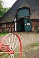
Also on the through road is the old ham smokehouse of the Braasch family, who still do their old handicrafts in a former half-timbered farmhouse with thatched roof from 1663. Many mute contemporary witnesses, such as furnishings, household items and tools, are gathered here like a museum. Free tours take place daily during shop opening hours.
Harmsdorf is the junction of signposted cycle paths that connect the central towns of Oldenburg i. H., Lensahn and the neighboring communities Hansühn and Schönwalde. However, a separate cycle path only exists between Harmsdorf and Lensahn.

Former village school
Ham museum and smokehouse

Inscription in the door frame of the Ham Museum


Web links
Individual evidence
- ↑ North Statistics Office - Population of the municipalities in Schleswig-Holstein 4th quarter 2019 (XLSX file) (update based on the 2011 census) ( help on this ).
- ↑ Schleswig-Holstein topography. Vol. 4: Groß Sarau - Holstenniendorf . 1st edition Flying-Kiwi-Verl. Junge, Flensburg 2004, ISBN 978-3-926055-75-0 , p. 126 ( dnb.de [accessed on May 1, 2020]).
- ↑ small mountains. In: batess.de. Stormarner Tageblatt, accessed on May 3, 2017 .
- ^ Community Harmsdorf, Ostholstein district in the municipal coat of arms of Schleswig-Holstein
- ^ Harmsdorfer Sportverein from 1925 e. V. In: Kreissportverband Ostholstein / Homepage , accessed on May 3, 2017.
- ↑ Make one out of two. (No longer available online.) Der Reporter, February 3, 2017, formerly in the original ; accessed on May 10, 2017 . ( Page no longer available , search in web archives ) Info: The link was automatically marked as defective. Please check the link according to the instructions and then remove this notice.
- ^ BMVI broadband atlas. BMVI - Federal Ministry of Transport and Digital Infrastructure, accessed on May 10, 2017 .
- ↑ Uwe Stock: Harmsdorf: Texts and pictures for the story . Ed .: Harmsdorf community. Oldenburg i. H. 2008, p. 378 .
- ↑ Harmsdorf Chapel In: Christ Church Hansühn , accessed on May 3, 2017.
- ↑ Monumental oaks - Gut Güldenstein. Retrieved April 30, 2017 .
Ahrensbök | Old brim | Bad Schwartau | Beschendorf | Bosau | Dahme | Damlos | Eutin | Fehmarn | Göhl | Gremersdorf | Grömitz | Großenbrode | Pit | Harmsdorf | Heiligenhafen | Heringsdorf | Kabelhorst | Kasseedorf | Kellenhusen (Baltic Sea) | Lensahn | Malente | Manhagen | Neukirchen | Neustadt in Holstein | Oldenburg in Holstein | Ratekau | Riepsdorf | Scharbeutz | Schashagen | Schönwalde am Bungsberg | Sierksdorf | Stockelsdorf | Süsel | Timmendorfer Strand | Wangels