Windach
| coat of arms | Germany map | |
|---|---|---|

|
Coordinates: 48 ° 4 ' N , 11 ° 2' E |
|
| Basic data | ||
| State : | Bavaria | |
| Administrative region : | Upper Bavaria | |
| County : | Landsberg am Lech | |
| Management Community : | Windach | |
| Height : | 599 m above sea level NHN | |
| Area : | 24.85 km 2 | |
| Residents: | 3814 (Dec. 31, 2019) | |
| Population density : | 153 inhabitants per km 2 | |
| Postal code : | 86949 | |
| Area code : | 08193 | |
| License plate : | LL | |
| Community key : | 09 1 81 146 | |
| LOCODE : | DE WH2 | |
| Community structure: | 6 parts of the community | |
| Association administration address: | von-Pfetten-Füll-Platz 1 86949 Windach |
|
| Website : | ||
| Mayor : | Richard Michl (Free Voters Windach) | |
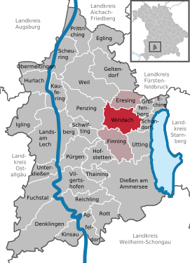
| Location of the municipality of Windach in the Landsberg am Lech district | ||
Windach is a municipality in the Upper Bavarian district of Landsberg am Lech and, together with the municipalities of Finning and Eresing, forms the administrative community of Windach , whose headquarters are in Windach Castle .
Parish parts

The municipality has six officially named municipality parts (the type of settlement is given in brackets ):
- Dürrhansl ( wasteland )
- Hechenwang ( Kirchdorf )
- Schöffelding ( parish village )
- Steinebach ( village )
- Weghäusl (wasteland)
- Windach (parish village)
There are the districts of Hechenwang, Oberwindach, Schöffelding and Unterwindach.
history
Hofmark
In 1157 the Lords of Windach were first mentioned in a document. Windach belonged to the Electorate of Bavaria . It was a closed Hofmark , which later came into the possession of the Barons von Füll and whose seat was Unterwindach.
Community merger
On April 1, 1939, the previously independent communities of Oberwindach and Unterwindach were merged to form the new community of Windach.
Incorporations
On January 1, 1972, the community Schöffelding and a large part of the community Hechenwang (without Achselschwang) were incorporated.
Population development
Between 1988 and 2019 the municipality grew from 2,338 to 3,814 by 1,476 inhabitants or 63.1%.
- 1970: 1741 inhabitants
- 1987: 2264 inhabitants
- 1991: 2565 inhabitants
- 1995: 2725 inhabitants
- 2000: 3214 inhabitants
- 2005: 3601 inhabitants
- 2010: 3668 inhabitants
- 2015: 3759 inhabitants
- 2018: 3834 inhabitants
- 2019: 3814 inhabitants
politics
mayor
Mayor is Richard Michl. In 2014 he succeeded Walter Graf. On March 15, 2020, he was re-elected with 70.3% of the vote.
Municipal council
The municipal council has 16 members.
| year | DGW | FWGS | FWW | WGH | BILO | total | Voter turnout in% |
|---|---|---|---|---|---|---|---|
| 2020 | 2 | 3 | 5 | 2 | 4th | 16 | 70.9 |
| 2014 | 4th | 3 | 4th | 2 | 3 | 16 | 65.6 |
| 2008 | 6th | 3 | 2 | 2 | 3 | 16 | 70.7 |
BILO = Citizens' Initiative Lebendiger Ortskern (since 2020 BILO / B90 Greens)
DGW = Village
Community Windach FWGS = Free Voter Community Schöffelding
FWW = Free Voters Windach
WGH = Voter Community Hechenwang
The 2008 municipal council election was contested and was repeated on September 28, 2008 after the district office had declared it invalid.
coat of arms
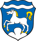
The description of the coat of arms reads: In blue under a silver wavy bar a jumping, gold-reinforced silver horse on a silver three-mountain.
Attractions
- Windach Castle , from 1610 (seat of the administrative association, freely accessible castle park)
- Catholic side church St. Petrus and Paulus (old parish church) and next to it the former rectory
- Parish church of St. Martin in Hechenwang, built by Joseph Schmuzer in 1740
- Large early medieval earthworks southwest of the village above the Windach ( Unterfinning ski jump )
- Small early medieval section fortification on the Burgleiten between Windach and Eresing ( section fortification Unterwindach )
See also: List of architectural monuments in Windach
Soil monuments
See: List of ground monuments in Windach
traffic
Windach has a junction on the A 96 Munich - Lindau .
Personalities
- Veronika Straaß (* 1957), German biologist, writer and translator
- Claus-Peter Lieckfeld (* 1948), German writer and journalist
Web links
- Entry on the coat of arms of Windach in the database of the House of Bavarian History
Individual evidence
- ↑ "Data 2" sheet, Statistical Report A1200C 202041 Population of the municipalities, districts and administrative districts 1st quarter 2020 (population based on the 2011 census) ( help ).
- ^ Community of Windach in the local database of the Bavarian State Library Online . Bavarian State Library, accessed on September 7, 2019.
- ^ Narziss Baader, History of the Hofmark Windach , in: Oberbayerisches Archiv Volume 46, pp. 242–277, Munich 1890.
- ↑ a b Wilhelm Volkert (Ed.): Handbook of the Bavarian offices, communities and courts 1799–1980 . CH Beck, Munich 1983, ISBN 3-406-09669-7 , p. 507 .
- ↑ Augsburger Allgemeine: Michl wins clearly , accessed on March 31, 2015
- ↑ Election of the first mayor - municipal elections 2020 in Windach - overall result. Retrieved March 19, 2020 .
- ↑ Election of the municipal council - municipal elections 2020 in Windach - overall result. Retrieved March 19, 2020 .
- ↑ Local elections in Bavaria on March 16, 2014 - Upper Bavaria municipal council elections. Retrieved October 2, 2017 .


