Kalkar (Bad Münstereifel)
|
Kalkar
City of Bad Münstereifel
Coordinates: 50 ° 35 ′ 46 ″ N , 6 ° 46 ′ 24 ″ E
|
||
|---|---|---|
| Height : | 238 m above sea level NHN | |
| Area : | 1.19 km² | |
| Residents : | 421 (December 31, 2018) | |
| Population density : | 354 inhabitants / km² | |
| Incorporation : | 1st July 1969 | |
| Postal code : | 53902 | |
| Area code : | 02253 | |
|
Location of Kalkar in Bad Münstereifel |
||
Kalkar (formerly Calcar) is a district of Bad Münstereifel in the Euskirchen district in North Rhine-Westphalia .
location
The place is north of the core town of Bad Münstereifel. The border to the neighboring town of Mechernich runs on the western outskirts . State road 11 runs through the village and federal road 51 on the eastern edge of the village . It separates the village from the Arloff district .
Former clay pits are to the west of the village. In the north lies the Kalkarer Moor nature reserve .
Place name
There are two well-known approaches to the origin of the place name Kalkar.
The name Kalkar is often derived from the Roman "calcaria" = limestone site. The nearby Roman lime distillery Iversheim could speak as an argument for this theory . However, the soil is not extremely calcareous.
According to Pastor Nikola Reinartz , the name comes from the good German word "Kolk", which means moor or lake. This is supported by the nearby Kalkarer Moor, as well as field names "in den Pölen" and "im See".
The spellings varied over time. Around the year 1300 "Kalken" or "Kalkel" was used, from around 1400 to 1800 "Kalker". Due to the local council resolution of March 24, 1936, the place name was changed to the current spelling "Kalkar".
history
Kalkar was first mentioned in the liber valoris around 1300. By 1350 at the latest, Kalkar belonged to the possessions of the counts and later dukes of Jülich.
The Roman road ran from Cologne to Trier not far from the town .
From 1816 to 1969 Kalkar was an independent municipality. On July 1, 1969, the previously independent municipality of Kalkar was incorporated into Bad Münstereifel.
In 1939 the village had a total of 90 inhabitants.
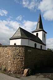
St. Ludgerus Chapel
The St. Ludgerus Chapel dates from the 16th century. In 1732 the village of Kalkar is listed as belonging to the Kirspenich parish . In 1770 the chapel was rebuilt as a single-nave, solid quarry stone building without any special architectural decoration.
In 1489 it was incorporated into the St. Chrysanthus and Daria monastery in Münstereifel. From this time on it was served by the pastor of the parish church St. Bartholomäus in Kirspenich, which was also incorporated into the Münstereifel monastery. From 1818 to 1974 the chapel belonged as a branch to the parish Heilig Kreuz Kreuzweingarten, after which it is again a branch of St. Bartholomäus Kirspenich.
Others
The RVK line taxi 801 drives through the town.
Web links
Individual evidence
- ↑ Population figures . Retrieved March 11, 2019 .
- ↑ Woenge.de. Retrieved May 19, 2019 .
- ↑ Woenge.de. Retrieved May 19, 2019 .
- ↑ Kalkar • City of Bad Münstereifel. Retrieved May 19, 2019 .
- ↑ Kalkar • City of Bad Münstereifel. Retrieved May 19, 2019 .
- ↑ Martin Bünermann: The communities of the first reorganization program in North Rhine-Westphalia . Deutscher Gemeindeverlag, Cologne 1970, p. 87 .
- ↑ Kalkar • City of Bad Münstereifel. Retrieved May 19, 2019 .


