Starzel (Neckar)
The Starzel is an almost 43 km long right tributary of the Neckar in the two Baden-Württemberg districts of Zollernalb and Tübingen .
geography
course
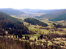
The Starzel arises directly on the Albtrauf on the European watershed , around three kilometers south of Hausen in Killertal (a district of Burladingen ), a few dozen meters north of the hamlet of Neuweiler, which belongs to Albstadt .
For historical reasons, the 14-kilometer long valley created by the Starzel on the northern edge of the Swabian Alb from the source to Hechingen is called Killertal . It is named after the village of Killer , whose parish was responsible for the entire valley. Historically, the name Killer is made up of a church and a hamlet .
At Hechingen, the Starzel on the left is fed by the Reichenbach . It now flows more to the west and is then reinforced again from the left side at the Stauffenburger Hof by its longest tributary, the Zimmerbach .
After the passage from Rangendingen it turns north and finally flows into Bieringen at an altitude of 354 m above sea level. NHN from the right into the Neckar .
Tributaries
List of tributaries with tributary side, inflow location, length (including mainstream upper reaches) and catchment area, where available. Other sources are noted.
Selection.
- Neubrunnen , from the right in Burladingen - Hausen im Killertal , 1.9 km
- Scharlenbach , from the left in Burladingen- Starzeln , 3.5 km and 6.1 km²
- Goosbach , from the left in Burladingen- Killer , 0.7 km
- Lindenbach , from the right in Killer, 1.9 km
- Buchenbach , from right to Killer, 1.9 km and 3.9 km²
- Hirschbach , from the right before Jungingen , 1.1 km
- Sulzgraben , from the right at the beginning of Jungingen , 0.8 km
- Mühlbächle , from the right in Jungingen, 1.8 km
- Bernenbächle , from the left at the end of Jungingen, 2.3 km and 2.7 km²
- Lotterbächle , from left to Jungingen, 1.4 km
- Weilerbächle , from the right at the communal border Jungingen / Hechingen , 1.0 km
- Buchbächle , from the right at the beginning of Hechingen- Schlatt , 1.2 km
- Wettbächle , from the left in Schlatt, 1.1 km
- Heiligenbach , from the right in Schlatt, 3.7 km and 5.7 km²
- Münchbach , from the right at the Schlatt / Hechingen district boundary, 2.4 km
- Reichenbach , from the left in Hechingen, 9.5 km and 19.4 km²
- Feilbach , from the left in Hechingen, 1.6 km
- Bräunestall , from the left in Hechingen, 1.3 km
- Sulzbach , from the left in Hechingen, 2.0 km
- Ettenbach , from the right end of the village of Hechingen to the district of Hechingen- Stein , 4.5 km and 5.5 km²
- Winterhaldenbach , from the right at the end of Stein, 3.0 km and 1.9 km²
- Tufelbach , from right to Stein, 0.7 km
- Zimmerbach , from the left at Hechingen- Stauffenburger Hof , 12.1 km and 25.4 km²
- Ramsbach , from the right, in front of the Hechingen / Rangendingen municipality border , 2.2 km
- Mönchgraben , from the right at the beginning of Rangendingen, 1.9 km
- Talbach , also Dorfbach , from the left at the end of Rangendingen, 6.1 km and 9.7 km²
- Sendelgraben , from left to Rangendingen, 3.4 km and 1.4 km²
- Bruckbach , from left to Rangendingen, 3.6 km and 4.6 km²
- Omengraben ( left , district boundary Rangendingen / Rangendingen- Höfendorf , 4.2 km and 3.5 km²)
- Ganggraben , from the right at Rangendingen- Bietenhausen , 2.4 km and 5.1 km²
- Tobelsgraben , from the left at the district boundary near Hirrlingen - Untere Mühle , 2.5 km and 9.8 km²
- Haldengraben , from the right at Rottenburg am Neckar - Frommenhausen , 0.6 km
![]() Map with all coordinates: OSM | WikiMap
Map with all coordinates: OSM | WikiMap
|
places
On its approximately 41 kilometers long route to the northwest, the Starzel passes through or grazes the following cities and towns:
- Hausen im Killertal (Burladingen)
- Starzeln (Burladingen)
- Killer (Burladingen)
- Jungingen
- Schlatt (Hechingen)
- Hechingen
- Stein (Hechingen)
- Rank things
- Hirrlingen
- Bietenhausen (Rangendingen)
- Bieringen ( Rottenburg )
In the town of Bieringen (district of Rottenburg) the Starzel flows into the Neckar.
Geology and geomorphology

From the White Jura to the Muschelkalk, the Starzel runs through all layers of the Jura and around two thirds of the Triassic . Its valley was created by regressive erosion , as the brook cut from the northwest into the layers of the Swabian Alb and its foreland. The valley of the Starzel extends eleven kilometers into the plateau of the Swabian Alb and is 957 m above sea level in the west . NHN high Raichberg and in the east from up to 840 m above sea level. NHN meter high hayfield flanked. It begins with the headwaters of the Starzel and its tributaries on the watershed between the river system of the Rhine and the Danube . A special feature are the so-called waterfall layers (soft Opalinus Clay, upper section of the Lower Aalenium). A waterfall has formed between Jungingen and Schlatt , the Junginger Gieß , behind which the Starzel has eroded about six meters into the soft brown Jura layer. For long stretches it moves in a natural stream bed. Between Jungingen and Hechingen it has deepened like a gorge.
Starzel floods in 2008
On the evening of June 2, 2008, a thunderstorm led to heavy rains and floods, as a result of which three women drowned, two in Jungingen and one in Hechingen . The " killer valley " made international headlines. Around 3.4 million euros were paid out to those affected to repair the material damage (1.5 million from donations, 1.8 million from the state of Baden-Württemberg). This means that all of the registered needs have been covered.
As a result of the disaster, the Starzeltal Flood Protection Association was founded in 2013 .
Protected areas
The Starzel flows through several protected areas, in the upper reaches the landscape protection area Oberes Starzeltal and Zollerberg , which with an area of 8,746 hectares is part of the markings of the municipalities of Bisingen, Burladingen, Hechingen and Jungingen. It was established by ordinance of the Hechingen District Office of December 19, 1972 and has the protected area number 4.17.048. In it lies the Zollerberg , a witness mountain of the Swabian Alb with Hohenzollern Castle .
This is followed by the Mittleres Starzeltal conservation area . Located in the districts of Hechingen and Rangendingen, it was decreed by the Hechingen District Office on October 10, 1963 with an area of 1293 hectares (protected area number 4.17.046).
Below Bietenhausen , the Starzel grazes the Kapfhalde nature reserve (11.8 hectares, ordinance of the Tübingen regional council of May 9, 1983, NSG number 4.104), which is located on a right-hand slope.
Hydroelectric power plant
After the Starzel hydropower plant on Burgmühle, west of the Rottenburg district of Frommenhausen, was repaired , it went back into operation in August 2014. The weir from the 1910s, which was impassable for fish and other aquatic animals, was replaced by a rough ramp ( location ). The dammed water flows through an approximately one kilometer long underground channel to the power station building ( location ). The computer system at the sewer inlet has a bar spacing of 15 millimeters. This prevents fish from getting into the power station sewer. A cross- flow turbine generates an output of 18 kW at a head of 5.8 meters. The plant is operated by the Rottenburg municipal utility .
particularities
The name of the municipality of Starzach , located on the lower reaches, was derived from the two rivers, Starzel and Eyach, which border it .
See also
Individual evidence
LUBW
Official online waterway map with a suitable section and the layers used here: Map of the course and catchment area of the Starzel
General introduction without default settings and layers: State Institute for the Environment Baden-Württemberg (LUBW) ( notes )
- ↑ Height according to the contour line image on the topographic map background layer .
- ↑ Altitude by interpolation between two height triangles labeled in blue in the Neckar course above and below the mouth on the background layer topographic map .
- ↑ a b Length according to the waterway network layer ( AWGN ) .
- ↑ a b Catchment area summed up from the sub-catchment areas according to the basic catchment area layer (AWGN) .
- ↑ Catchment area according to the basic catchment area layer (AWGN) .
Other evidence
- ↑ Friedrich Huttenlocher : Geographical Land Survey: The natural space units on sheet 178 Sigmaringen. Federal Institute for Regional Studies, Bad Godesberg 1959. → Online map (PDF; 4.3 MB)
- ↑ Baden-Württemberg Ministry for the Environment, Climate and Energy: Potential to expand hydropower up to 1,000 kW in the Neckar catchment area, taking into account ecological management goals , May 2011, p. 8, accessed on October 8, 2014 (PDF, 1.9 MByte). With a catchment area of 178.1 km², which deviates slightly from the LUBW value.
- ↑ LGRB profile geotope waterfall and layers of the Starzel near Schlatt: [1]
- ↑ Spiegel Online : Devastating floods - three people drown in a storm inferno in the Killertal
- ↑ State Gazette No. 12 of April 3, 2009, page 12.
- ↑ www.hechingen.de
- ↑ http://www2.lubw.baden-wuerttemberg.de/public/abt2/dokablage/oac_12/kurzbeschreibung/4/4104.htm .
- ↑ Starzeltal: The current is flowing again , p. 12 (PDF, 2.2 MByte) rojournal, Nov. 2014
- ↑ Information board on the power plant building
literature
- Topographic map 1: 25,000 Baden-Württemberg, as a single sheet No. 7518 Horb am Neckar, No. 7519 Rottenburg am Neckar, No. 7618 Haigerloch, No. 7619 Hechingen, No. 7620 Jungingen and No. 7720 Albstadt
Web links
- Map of the course and catchment area of the Starzel on: State Institute for the Environment Baden-Württemberg (LUBW) ( information )
- Measuring table sheets in the Deutsche Fotothek :
- 7518 Horb (Württ.) Imnau (Preuss.) From 1909
- 7519 Rottenburg (Württ.) Bietenhausen (Preuss.) From 1909
- 7618 Haigerloch (Preuss.) Binsdorf (Württ.) From 1908
- 7619 Hechingen / Bodelshausen from 1910
- 7620 Talheim / Jungingen from 1910
- 7720 Ebingen / Burladingen from 1910


