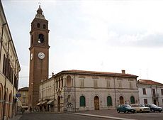
Luzzara
| Luzzara | ||
|---|---|---|

|
|
|
| Country | Italy | |
| region | Emilia-Romagna | |
| province | Reggio Emilia (RE) | |
| Local name | Lüsèra | |
| Coordinates | 44 ° 58 ′ N , 10 ° 40 ′ E | |
| height | 22 m slm | |
| surface | 39 km² | |
| Residents | 8,703 (Dec. 31, 2019) | |
| Population density | 223 inhabitants / km² | |
| Post Code | 42045 | |
| prefix | 0522 | |
| ISTAT number | 035026 | |
| Popular name | Luzzaresi | |
| Patron saint | George | |
| Website | Luzzara | |
Luzzara is an Italian municipality ( comune ) with 8703 inhabitants (as of December 31, 2019) in the province of Reggio Emilia in Emilia-Romagna . The municipality is located about 29 kilometers north of Reggio nell'Emilia directly on the Po and borders the province of Mantua ( Lombardy region ), the so-called Oltrepò Mantovano . Luzzara is located about 24 kilometers south-southwest of Mantua .
history
The ancient Roman city of Nuceria is said to have been destroyed by Celtic barbarians, and today's Luzzara was later built in its place . 781 the name appears for the first time in a document of Charlemagne .
Economy and Transport
Numerous machine manufacturers produce in Luzzara. Among them is the tractor manufacturer Argo . One stop is on the non-electrified railway line from Parma to Suzzara .
Personalities
- Maurizio Cazzati (1616–1678), composer
- Cesare Zavattini (1902-1989), screenwriter
- Danilo Donati (1926–2001), costume and production designer
Web links
Individual evidence
- ↑ Statistiche demografiche ISTAT. Monthly population statistics of the Istituto Nazionale di Statistica , as of December 31 of 2019.


