
Mojave National Preserve
| Mojave National Preserve | |||
|---|---|---|---|
 |
|||
|
|||
| Location: | California , United States | ||
| Next city: | Baker | ||
| Surface: | 6,211 km² | ||
| Founding: | October 31, 1994 | ||
| Visitors: | 632,521 (2005) | ||


.jpg)
The Mojave National Preserve is a National Park Service protected area in western San Bernardino County in the state of California .
location
The Preserve is located in northeast San Bernardino County in the Mojave Desert . It is bounded by Interstates 15 (to the north) and 40 (to the south), the border with the state of Nevada in the east and the Bristol Mountains in the southwest. One exclave is located near Mountain Pass north of Interstate 15, where Clark Mountain ( 2,417 m ) is the highest point in the park. South of Baker is the lowest point of the park area at around 270 m , the highest point in the southern part of the park is in the New York Mountains and reaches 2296 m . The Mojave National Preserve encloses the Providence Mountains State Recreation Area , Mitchell Caverns Natural Preserve, and Granite Mountain Natural Preserve , which are administered by the California Department of Parks and Recreation . The Castle Mountains National Monument borders in the east .
geology
The Mojave National Preserve is a geologically extremely diverse area, which is already visible to laypeople. The mountain ranges, which mostly cross the park in a northeast-southwest direction, consist of old Proterozoic metamorphites , limestone and sandstone , which were deposited around 500 million years ago off the then American west coast, as well as tertiary volcanites . About 245 million years ago the subduction of the Farallon Plate began under the North American Plate , which on the one hand led to mountain formation and the uplift of the region, on the other hand to increased volcanic activity. Some of the magmas got stuck in the earth's crust and solidified into plutons , most of which were formed around 90 million years ago ( Lower Cretaceous ).
With the formation of the San Andreas Fault around 28 million ( Oligocene ) years ago, the tectonic situation in the Mojave changed. The region experienced a strong crust expansion during which the old rocks were exposed and the characteristic isolated mountain ranges were formed. With the expansion of the crust, there was also increased volcanism. From 18.5 to approx. 10 million years ago it occurred e.g. B. in the region around the Wood Mountains to partly explosive volcanism. The erosion forms of the Hole-in-the-Wall-Canyon originated in these volcanic rocks . The most recent lava flows in the Mojave National Preserve are only 16,000 years old and are found in the Cima Volcanic Field.
The current appearance of the Mojave was shaped, among other things, by the Ice Age meltwater lakes, which reached their peak around 23,000 years ago. Their slow drying out left extensive playas such as Soda Lake. From these loose material, following the main wind direction from the northwest, was deposited as aeolian sediment at the foot of the nearest mountain ranges . a. the Kelso Dunes emerged.
climate
Due to the location, the climate varies greatly and is characterized by extreme differences both during the day and during the year. In general the climate is arid and winter cold; the rainfall, which comes down mainly in the form of summer thunderstorms, varies between 86 mm per year near Baker and 230 mm per year in the mountainous regions.
winter
In the mountain peaks, a permanent snow cover is not uncommon in winter, the temperatures in the peaks drop to around −20 ° C, in valleys the minimum temperature is −7 ° C. Occasionally low pressure areas in the Pacific Northwest bring rain and snowfall, but the rain shadow of the Sierra Nevada means that mostly only clouds and wind penetrate to the Mojave National Preserve. The daily highs in winter reach 27 ° C in protected valleys.
spring
The spring climate is mostly determined by the low pressure areas in the northwest of the United States at the beginning ; this influence only decreases from April; the likelihood of precipitation also decreases. As early as May, the daytime temperature is more than 32 ° C, in isolated cases around 40 ° C.
summer
Summer is determined by extreme heat and the North American monsoons. Maximum daily temperatures of around 50 ° C are not unusual. The combination of high temperatures, low humidity, and low air pressure attracts moist air masses from the Gulf of Mexico, which create thunderstorms in the deserts of the southwest. In this way, severe thunderstorms can occur between mid-June and early September.
autumn
Pacific low pressure systems ensure relatively calm, pleasant weather, temperatures are between 20 ° C and 32 ° C, October is the month with the lowest rainfall during the year.
Natural space
The following biotopes can be distinguished in the area of the park due to the differences in terms of both altitude and rainfall:
- Pine Juniper Forest (Pinyon Juniper Woodland)
- Joshua Tree Woodland
- Cactus yucca scrub (Cactus Yucca Scrub)
- Desert Dunes
- Creosote Bush Scrub
- Dry valley (desert wash)
- Salt Pan
In addition, in the rainier mountain regions there are isolated forests of California mugwort (Artemisia californica) and blackbrush (Coleogyne ramosissima) , especially in the northern part of the park there are some low- vegetation lava flows.
Pine Juniper Forest
Character plants of this biotope, which can usually be found on the more humid northern slopes at higher altitudes, are:
- Utah Juniper (Juniperus osteosperma)
- Solitary Juniper (Juniperus monosperma)
- Rocky Mountain Juniper (Juniperus scopulorum)
- California Juniper (Juniperus californica)
- Stone pine (Pinus edulis)
- Single-leaved pine (Pinus monophylla)
- Sagittarius (Artemisia tridentata)
- Menzies Goldbusch (Isocoma menziesii)
- Mojave prickly pear (Opuntia phaeacantha)
In addition, different types of Castilleja ( Indian Paintbrush ) are typical for open areas of this area.
Bighorn sheep (Ovis canadensis) can be observed near the few permanent water points .
Joshua Palm Lily Forest
This biotope appears to be much poorer in species, as the palm lily species from which it is named forms extensive populations. For the most part, these forests extend in intermediate locations along gently sloping slopes. In addition to the Joshua palm lily ( Yucca brevifolia ) - the world's largest closed population of this species extends around the Teutonia Peak at the Cima Dome - the following species are typical of this biotope:
- Blue palm lily (Yucca baccata)
- Mohave palm lily (Yucca schidigera)
- Echinocereus triglochidiatus
- Senecio flaccidus
In particular, during the flowering of the latter two species an extensive insect fauna is found, typical species of fauna of this area are the Yucca night lizard (Xantusia Vigilis) , the Scott-Trupial (Icterus parisorum) and American kestrels (Falco sparverius) .
Cactus yucca bushland
These plant populations, which can usually be found in south-central locations, correspond most closely to the usual idea of a desert, columnar cacti and low palm lilies determine this biotope. Mojave rattlesnakes (Crotalus scutulatus) are relatively common, and the open landscape allows observation of helmet quails (Callipepla gambelii) .
dune
The over 200 meter high dunes west of Kelso are created by the drifting of sand from Soda Lake, the valley of the Mojave River and from Devils Playground at the foot of the Granite Mountains. Large areas of this biotope have no plant cover, in isolated cases - especially in depressions - there are various types of evening primrose (Oenothera) and splendid fissures (Liatris) as well as desert chicory (Rafinesquia neomexicana) , pink sand verbena (Abronia umbellata) and Indian ricegrass (Oryzopsis hymenoides) . The fauna presents itself with the Mojave fringed foot (Uma scoparia) , the sidewinder rattlesnake (Crotalus cerastes) , various types of kangaroo rats (Dipodomys) and their most important hunters, the kit fox (Vulpes velox) .
Creosote scrubland
The eponymous creosote bush (Larrea tridentata) dominates the plains of the protected area, with Cylindropuntia , Echinocereus , Sphaeralcea incana and Encelia farinosa here and there . This biotope is home to the road cuckoo (Geococcyx californianus) and the endangered California gopher tortoise (Gopherus agassizii) .
Dry valley
Valleys, which absorb the runoff water after the few rains, represent the most species-rich area of the Mojave National Preserve. Deep-rooted plants are common for this biotope, the banks are partially shaded by Chilopsis linearis and Populus Fremontii . Acacia greggii , Hymenoclea salsola , Atriplex canescens and Senecio barbertonicus form the dense undergrowth in places . Desert mistletoe (Phoradendron californicum) parasizes in the crowns of the trees . The pied flycatcher (Phainopepla nitens) lives on the fruits of this plant , and this zone is also used by numerous migratory birds ( finches , oriole and tanagers ) after rainfall . The red spotted toad (Bufo punctatus) can only be observed after rainfall . The mammals are represented by the donkey hare (Lepus californicus) and the coyote (Canis latrans) .
Salt flat
Salt flats are an extremely hostile landscape, after rainfall periodic lakes form in them , some of which have an extreme salt content and are only used by adapted insects and crustaceans ; At this time amphibians and birds gather in the bank area, which these invertebrates serve as food. After these waters dry out, no animals stay in these areas for a long time. In the area of the Mojave National Preserve there is an extensive biotope of this type with Soda Lake.
Human settlement and history
Indians
The first evidence of settlement in the area of today's Mojave National Preserve are around 10,000 to 7,000 years old and were mainly found in the shores of Lake Mojave, which was then still present . Since the area was then unsuitable for permanent settlement due to the progressive drying out and the seasonal availability of sufficient food, the area was roamed by nomadic hunters and gatherers. Despite the increasing drought, the introduction of new technologies in food preparation and storage led to an increase in the population about 4000 years ago; she lived on the fruits of cacti, pines and juniper and hunting bighorn sheep, donkey hares and other animals. In the area now under protection there are some springs that ensured the supply of drinking water.
It was only after the turn of the century that a new era began with the introduction of the bow and arrow and the technology of pottery, from around 1200 peoples of the Paiute and Schoschone from the northwest pushed the Mojave, who had previously lived here, into the valley of the Colorado River. From the San Bernardino Mountains originating Serrano eventually settled in the area of the park.
European exploration
The exploration by Europeans begins with the expedition of Juan de Oñate , who came from Santa Fe at the beginning of the 17th century to the lower reaches of the Colorado River . Formally, the area was part of the Spanish colonial empire, but no settlements or missions were established; only Francisco Hermenegildo Tomás Garcés led in 1776 by Yuma Coming another expedition to this area in. Only after the area had fallen to Mexico through independence , the exploration efforts intensified, Peter Skene Ogden explored the present-day border area of Nevada and California in 1829/30, Jedediah Smith crossed the area as early as 1826. In the spring of 1844, John Charles Frémont reached the area; he followed an emerging trade route between Los Angeles and Taos in New Mexico , the Spanish Trail . One last expedition - led by Robert Stockton Williamson and John Grubb Parke - came to what is now the Mojave National Preserve in the spring of 1853. The exact mapping of the area was done around 1872 by George Montague Wheeler .
Development
The first military facilities had already been created beforehand, in 1866 the establishment of Camp Rock Springs took place, but this was abandoned after only 17 months in 1868 after the postal routes were changed. In the far east of today's park, Fort Piute was built from November 17, 1867, but it was abandoned again on May 3, 1868.
The first prospectors found gold , silver , lead and copper in the New York Mountains and the Ivanpah Mountains , and the first localities emerged in the last decade of the 19th century. None of these localities achieved supra-regional importance, as the supply of drinking water was particularly problematic. Vanderbilt , founded in 1891 in the east of the Preserve, had a population of around 400 in 1894, but the post office opened in 1893 was closed again in 1900.
The development of the area by railroad lines led to the establishment of some villages that served both the railroad companies and the few extensive ranchers who ran extensive cattle as a supply center. First, the Santa Fe Railroad built a railway line that - coming from Needles - runs along the southern border of the reserve and then continues in the direction of Barstow . The Nevada Southern Railway , which was acquired by the Santa Fe Railroad in 1902, reached Barnwell in 1893, which was then still called Manvel. This place was the starting point of a line that the California Eastern Railway built to Ivanpah. The construction of the route of the Los Angeles and Salt Lake Railroad across the current sanctuary led to the establishment of several localities.
The following were created as supply points for the railway companies:
The change in technology from the steam locomotive to the diesel locomotive and the abandonment of the mines on the grounds of today's park led to the decline in the importance of the localities, so that they are now ghost towns or are only inhabited by a few people.
Since the beginning of the Second World War, parts of the Mojave Desert have been used as a military training area and for testing weapon systems.
natural reserve
In 1981 it was decided to establish the East Mojave National Scenic Area and to submit it to the administration of the Bureau of Land Managements . The protected area corresponded to the National Preserve created by the California Desert Protection Act (October 31, 1994); this law also designated 2813 km² as a wilderness area , which only allows restricted use.
Since 2011, a center for the research and protection of the California gopher tortoise has existed on the edge of the park. The center has belonged to the National Park Service since 2014, the scientific work is done by the University of California, Davis and the Savannah River Ecology Lab .
Geographical features
Apart from the aforementioned biogeographical differences, the park's terrain is made up of various morphologically different manifestations.
Beale Mountains
Location: 35 ° 10 ′ 40 ″ N , 115 ° 36 ′ 15 ″ W.
The Beale Mountains are a mountain range only around 4 kilometers long northeast of the Kelso Mountains within the Cinder Cone National Natural Landmark, which reaches an altitude of around 1,400 m . The mountain range lies in the rain shadow of higher mountain ranges and is one of the rain-poorest mountains in the park. They were named after Edward Fitzgerald Beale .
Cima Dome & Volcanic Field National Natural Landmark
Location: 35 ° 25 ′ 0 ″ N , 115 ° 35 ′ 0 ″ W.
Cima Dome is a shallow dome structure that as a result of erosion of a granite - pluton was that while the front of at least 80 million years subduction plate Farallon was created under the North American plate of. It rises around 450 meters above the surrounding plain and reaches a height of 1509 meters. It is a very symmetrical elevation that covers an area of around 180 km² and is clearly visible northwest of Cima on the connecting road to Interstate 15. The world's largest forest of Joshua palm lilies is found on its slopes as well as the surrounding mountains.
The Cima Volcanic Field contains 52 cinder cones with heights between 25 and 150 meters above the surrounding plain, with diameters varying between 200 and around 1000 meters at the base. The approximately 30 elevations in the southern area and the associated basaltic lava flows originated in the Pleistocene , the northern group was created by eruptions during the Holocene. These volcanic phenomena take up around 150 km² in the north of the Mojave National Preserve.
Clark Mountain
Location: 35 ° 31 ′ 32 ″ N , 115 ° 35 ′ 19 ″ W.
Clark Mountain is located in an exclave of the Mojave National Preserve north of Mountain Pass , above which it rises steeply to an altitude of 2,418 meters. The vegetation of the lower area consists of forests of creosote bushes and Joshua palm lilies, the summit area consists of forests of pine, juniper and gray spruce (Abies concolor) .
The limestone summit is considered an outstanding climbing area.
Clipper Valley
Location: 34 ° 55 ′ 0 ″ N , 115 ° 20 ′ 0 ″ W.
The Clipper Valley is an extensive alluvial plain in the south of the Preserve, which is located between the Providence Mountains and the Clipper Mountains , which are already outside the park ; the border to the east adjoining Fenner Valley is formed by the Fenner Hills. The plain, measuring more than 1000 km², is dominated by the heavily eroded Blind Hills and Halfway Hill (822 meters).
Devils Playground
Location: 34 ° 56 ′ 55 ″ N , 115 ° 49 ′ 36 ″ W.
Devils Playground is a plain interspersed with a few hills in the southwest and west of the Mojave National Preserve. This extremely low-vegetation area, which consists largely of flat dunes and small salt flats, extends for around 65 kilometers between the Cronese Mountains outside the park and the Granite or Providence Mountains.
Fenner Valley
Location: 34 ° 45 ′ 0 ″ N , 115 ° 15 ′ 0 ″ W.
The Fenner Valley is a largely outside of the preserve, 70 kilometers long and up to 15 kilometers wide alluvial plain. It is separated from the Clipper Valley by the Clipper Mountains and Fenner Hills, and in the southeast the Old Woman Mountains and the Piute Mountains form the border. The valley rises from southwest to northeast, near the Marble Mountains the height is only around 400 meters, near Goffs it is around 800 meters.
Through the Fenner Valley the Route 66 led , which led to the establishment of some villages along this route; in the Fenner Valley are the villages of Goffs, Fenner , Danby and Essex . In addition, the Burlington Northern Santa Fe Railway , also used by Amtrak , runs through the valley.
Granite Mountains
Location: 35 ° 30 ′ 50 ″ N , 116 ° 44 ′ 18 ″ W.
This small mountain range measuring around 15 kilometers in diameter is located in the southwest of the Preserve and is separated from the Providence Mountains by the Granite Pass (1226 meters). It reaches its greatest heights in Granite Peak (2061 meters) and Silver Peak (1940 meters).
Some of the Mojave Desert's most unusual geological formations are found in this mountain range, which is managed in part by the Granite Mountains Natural Reserve independently of the Mojave National Preserve.
The granites in the area of the park date from the Mesozoic Era and are at least 80 million years old. They originated at a time when large parts of the western edge of the North American continent (Laurentia) were part of a subduction zone and therefore may have been quite similar to today's western edge of South America with the Andes . As a result of the drainage of the subducted oceanic earth crust of the primeval Pacific, magmas rose into the overlying continental crust . Part of the magma reached the surface of the earth at that time and caused intense volcanism there , while another part still solidified within the crust as so-called plutons . The latter include the rocks of the Granite Mountains. At least 60 million years passed between the time of crystallization and the exposure of the granitoid plutons as a result of the erosion of the rock above.
There are numerous springs in the area of the Granite Mountains, but most of them only have periodic water.
Ivanpah Mountains
Location: 35 ° 22 ′ 30 ″ N , 115 ° 30 ′ 25 ″ W.
This mountain range, around 18 kilometers long, is located east of the Cima Dome in the north of the park, directly south of Mountain Pass. The highest peaks are the Kokoweef Peak (1840 meters) at the north and the Kessler Peak (1878 meters) at the southern end of the mountain range. The Morning Star Mine, the Kokoweef Mine and the Allured Mine are the centers of mining in these mountains.
Ivanpah Valley
Location: 35 ° 25 ′ 0 ″ N , 115 ° 20 ′ 0 ″ W.
The Ivanpah Valley - located between the Ivanpah Mountains and Clark Mountain in the northwest and the New York Mountains in the southeast - takes up most of the northeast of the Mojave National Preserve and goes beyond it. Some of the park's dry valleys lead to Ivanpah Lake and Roach Lake , which are already north of the park's boundaries. In the Ivanpah Valley are the towns of Cima, Ivanpah and Nipton in California and Jean and Primm in Nevada.
Kelso Dunes
Location: 34 ° 54 ′ 40 ″ N , 115 ° 43 ′ 17 ″ W.
The Kelso Dunes are a field of dunes created by Aeolian transport in the southwest of the nature reserve. They emerge seamlessly from the Devil Playground and are separated from the Kelso Mountains to the south by the Devils Playground Wash. The dunes of the 120 km² area reach heights of up to 200 meters above the surrounding area.
Most of the sand accumulated here consists of quartz and feldspar , with magnetite and amphibolite to a lesser extent . The main source of the material is likely to be the San Bernardino Mountains, the arrangement and morphology of the sand suggest that a large part of the material comes from the basin of the Mojave River - especially from the Afton Canyon area - via intermediate storage facilities in the Devils Playground area . However, climatic changes over the past few decades have resulted in new sands being deposited directly in the area of the Mojave River valley and the Devils Playground, but not in the Kelso Dunes. Changes of this kind have led to a clear stratification in the area of the Kelso Dunes, as in the course of the formation during the last 25,000 years longer periods without the entry of new material were associated with the settlement of vegetation and the stabilization of the dunes. The Kelso Dunes serve as a climate indicator, with the eastern areas of the dunes dating back to the time when Soda and Silver Lake were formed. Currently there are shifting dunes, dunes fortified by vegetation, sand fields and sand ramps in the dune field. The phenomenon of the singing dunes has been proven for the Kelso Dunes.
The use of vehicles in this part of the preserve is not permitted, but the Kelso Dunes are one of the most popular areas of the nature park due to their easy access.
The Kelso Dunes are home to some endemic species, including:
- Macrobaenetes kelsoensis - from the Macrobaenetes family (from the suborder long- feeler terrors )
- Ammopelmatus kelsoensis - from the family of the Stenopelmatidae (from the order of the jumping horror )
- Rhaphiomidas tarsalis - from the family of the Mydidae (from the order of the two-winged )
- Eremopedes kelsoensis - from the family Tettigoniidae (from the suborder long-feeler terrors)
In addition, this area of the park is the habitat of some non-rare animal and plant species.
Kelso Mountains
Location: 35 ° 5 ′ 21 ″ N , 115 ° 44 ′ 23 ″ W.
The Kelso Mountains are a mountain range about 12 kilometers long northeast of the Devils Playground. They reach their greatest height in Kelso Peak at 1,452 meters.
Lake Tuendae
Location: 35 ° 8 ′ 36 ″ N , 116 ° 6 ′ 14 ″ W.
Lake Tuendae - an artificial pond in Zzyzx with a surface area of around 5600 m² - is the largest permanent body of water in the park, which is supplied with water by the Soda Springs. It is home to the now endemic species Gila bicolor mohavensis , a fish from the carp family . American coots (Fulica americana) can often be seen abandoned in the pond .
Lanfair Valley
Location: 35 ° 17 ′ 0 ″ N , 115 ° 6 ′ 0 ″ W.
The Lanfair Valley is an almost elliptical valley in the east of the reserve, which is bounded by the New York Mountains, the Woods Mountains, the Vontrigger Hills, the Piute Range and the Castle Mountains outside the park area; it rises to an average of around 930 meters. In the middle of the valley rise the Grotto Hills and the Lanfair Buttes, which reach up to 1,329 meters. The valley and the ghost town in it were named after Ernest Lanfair, an early settler in the area.
Apart from a few mines in the surrounding mountains, the valley was dominated by agriculture. Even today, a significant part of the valley, which largely consists of forests of Joshua palm lilies, is privately owned.
Marl Mountains
Location: 35 ° 9 ′ 0 ″ N , 115 ° 40 ′ 0 ″ W.
Immediately adjacent to the Kelso Mountains and only separated from the Beale Mountains by a wide dry valley, this mountain range, only around 7 kilometers long, in the center of the preserve is mainly known for the spring of the same name located on its northeast flank.
Mid Hills
Location: 35 ° 12 ′ 0 ″ N , 115 ° 27 ′ 0 ″ W.
The Mid Hills are - as their name suggests - in the center of the Mojave National Preserve, despite their name they reach an altitude of 1,873 meters in Pinto Mountain. They lie at the intersection of the Providence, New York and Woods Mountains; some of the park's most scenic areas are found here, such as the Round and Gold Valleys and Macedonia Canyon. On the north slope and near Mid Hill Campground are the only stocks of California mugwort in the reserve area.
New York Mountains
Location: 35 ° 22 ′ 12 ″ N , 115 ° 9 ′ 42 ″ W.
This mountain range, which extends well beyond the park grounds into the state of Nevada, takes up a large part of the northeast of the park and separates Lanfair Valley in the southeast from the Ivanpah Valley in the northwest. The ridge, which extends for about 36 kilometers, reaches an altitude of 2296 meters in an unnamed peak north of Caruthers Canyon.
Piute range
Location: 36 ° 13 ′ 0 ″ N , 115 ° 0 ′ 20 ″ W.
The mountain range in the far east of the park stretches in a north-south direction for about 22 kilometers and separates the Lanfair Valley from the Piute Valley, above which it suddenly rises several hundred meters. The mountain range has no prominent elevation, in its southern part are the Piute Canyon, the Piute Spring and the remains of the fort that was formerly located here, some of the most interesting sights in the park, which can be reached relatively easily from Laughlin via Nevada State Route 163 and the US Get to Highway 95 .
Providence Mountains
Location: 35 ° 0 ′ 0 ″ N , 115 ° 31 ′ 30 ″ W.
The Providence Mountains are a mountain range in the southwestern part of the Preserve, which extends for almost 40 kilometers into the central part. It reaches its greatest height in Edgar Peak with 2183 meters. East of Fountain Peak (2,132 meters) is the Providence Mountains State Recreation Area , which in turn encloses the Mitchell Caverns Natural Preserve . In the more humid altitudes there is a stand of oaks of the species Quercus turbinella .
Francisco Garcés crossed Cedar Canyon, a pass between New York and Providence Mountains, on his expedition. He named the mountain range between Van Winkle Mountain and Crescent Peak as Sierra de Santa Coleta . The mountain range got its name from grateful travelers in the early 19th century who wanted to thank Divine Providence for the available sources . This mountain range has been a center of mining since the late 19th century.
Shadow Valley
Location: 35 ° 27 ′ 30 ″ N , 115 ° 45 ′ 0 ″ W.
The valley, which is largely outside the park, extends in a crescent shape west of the Cima Dome northeast of the Beale and Marl Mountains; it is separated from the Ivanpah Valley by the Wildcat Butte (1,579 meters). The chain of hills to the west is largely shaped by the Cinder Cone Lava Beds.
Soda Lake and Soda Spring
Location: 35 ° 9 ′ 55 ″ N , 116 ° 4 ′ 17 ″ W.
Soda Lake is a mostly dry lake in the northwest of the park. The body of water, which is 24 kilometers long and 10 kilometers wide, receives periodic water from the Mojave River . Together with the Silver Dry Lake , the 288-meter lake forms the Holocene Lake Mojave . The evaporating water leaves a crust of sodium carbonate and sodium bicarbonate .
West of the lake, a road leads to a spring at the foot of Springer Mountain, originally known as Soda Spring, but has been renamed Zzyzx for marketing reasons . This spring forms Lake Tuendae, the only permanent open body of water in the park area.
Van Winkle Mountain
Location: 34 ° 46 ′ 0 ″ N , 115 ° 36 ′ 0 ″ W.
Van Winkle Mountain is a mountain range in the south of the Mojave National Preserve, which reaches a height of 1,401 meters. The Van Winkle Spring rises on the northern slope of the volcanic mountain.
Vontrigger Hills
Location: 35 ° 3 ′ 55 ″ N , 115 ° 6 ′ 59 ″ W.
The Vontrigger Hills rise to the south of the reserve north of Goffs and separate the Lanfair Valley from the Fenner Valley. They reach a maximum height of 1220 meters, on their western slope is the Vontrigger Spring.
Woods Mountains
Location: 35 ° 4 ′ 0 ″ N , 115 ° 21 ′ 15 ″ W.
The Woods Mountains are an extremely rugged mountain range in the south of the Mojave National Preserve, which is more like a collection of individual mountain sticks. The highest heights are reached in Tabletop Mountain (1882 meters) and Tortoise Shell Mountain (1405 meters). To the west of the ridge is the area known as Hole-in-the-Wall.
traffic
air traffic
Airports of national importance are located in Bullhead City and Las Vegas ; Baker , Needles , Jean and Searchlight also have airfields. In the northern part of the Ivanpah Valley, located outside the park between Primm and Jean, the construction of the Ivanpah Valley Airport is planned to complement McCarran International Airport ; the opening date was initially given as 2017; The project planning is currently suspended, so that a later date can be assumed.
Rail transport
The Mojave National Preserve is crossed by the Union Pacific Railroad on the route between Nipton and Barstow; it is used exclusively for freight traffic. Passenger traffic on this line to Kelso was stopped on August 14, 1964.
The route of the Burlington Northern Santa Fe Railway , which is also used by Amtrak , runs along the southern edge of the reserve . The closest stops to the daily Southwest Chief are in Needles and Barstow.
In connection with the construction of the Ivanpah Valley Airport, the construction of a high-speed route between Victorville and Las Vegas, the Desert Xpress, was planned; in addition, the California-Nevada-Interstate maglev train should run parallel to Interstate 15 parallel to the park's northern boundary. For both projects, which are currently dormant, the airport would be the stopping point closest to the park.
Road traffic
Interstates 15 and 40 run parallel to the north and south of the Preserve, and US Highway 95 runs near the western limit . Other roads of national importance are the Nevada State Route 164 and California State Route 164 northwest and along the northern border and the Goffs Road on the southwest edge of the park. Route 66 ran not far south of today's protected area .
There are no state routes or other roads of national importance within the Mojave National Preserve, only a paved connection - the Kelbacker Road - connects the north with the south of the park via the Granite Pass. Further paved stretches open up the most important sights, in the south the Lanfair Road leads from Goffs to the Vontrigger Hills and continues unpaved over the New York Mountains; Essex Road leads from Exit 100 of Interstate 40 to Mitchell Caverns Natural Preserve, while the Black Canyon Road that branches off from it leads to Hole-in-the-Wall.
In the north of the park there is the Ivanpah Road, which is paved to the foot of the New York Mountains and as a developed Gravel Road continues to Lanfair Rod, the Morning Star Road that branches off from it leads to Cima. This settlement is also the starting point of the Cima Road (to exit 272 of Interstate 15) and the Kelso Cima Road, which connects the places of the same name parallel to the route of the Union Pacific Railroad. In the northeast of the park runs the partially paved Zzyzx Road, which provides access from Exit 239 of Interstate 15 to Zzyzx.
There are also some unpaved roads and numerous tracks - including the Mojave Track - in the park area.
tourism
National Park Service
The headquarters of the Mojave National Preserve is located in Barstow, where information can be obtained and publications on relevant topics can be purchased.
The National Park Service maintains visitor centers in Kelso and Hole-in-the-Wall where rangers provide tourist information. In addition, both have toilets and a bookstore. The facility, which is housed in the former Kelso Depot, Restaurant and Employees Hotel, also has a restaurant, an art gallery and a fully equipped museum. This building, constructed in 1923, was listed on the National Register of Historic Places on August 2, 2001 .
Tourist infrastructure
There are three campsites on the site of the reserve, plus one on the Providence Mountains State Recreation Area. There are no other accommodations.
There are no petrol stations in the entire territory of the reserve, only in Kelso and Cima there is a modest amount of food available. Public telephones are only found in Cima and the Providence Mountains State Recreation Area, other than Visitor Centers.
North of the unpaved Aikens Mine Road was a lonely telephone booth between the 1960s and 2000, which gained nationwide popularity as the Mojave Telephone Booth, especially from 1997; the dismantling was carried out at the request of the National Park Service, as the telephone booth itself and its surroundings suffered from increasing vandalism.
Trails
Today, the preserve is best known for its numerous four-wheel drive roads and some of the most beautiful hikes in southern California.
The Mojave Trail is the best-known dirt road, it leads over a distance of 222 kilometers from the San Bernardino Mountains to the Colorado River, which was already followed by the indigenous people along many of the springs of the park. In addition, the area of the park is criss-crossed by a narrow network of desert trails that open up all the sights.
Hiking areas are in particular the valleys and canyons on the southern flank of the mountains in the central part of the reserve, such as the Hole-in-the-Wall Canyon and the Caruthers Canyon.
gallery
- Mojave National Preserve

Joshua palm lilies in the Ivanpah Valley, with the New York Mountains in the background

Creosote bushes in front of the Ivanpah Mountains

Railway line near Cima

Visitor center in the former train station in Kelso

View of the Kelso Dunes and the Granite Mountains
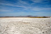
Soda Lake

Lake Tuendae in Zzyzx

Hole-in-the-Rock Canyon

View from the Piute Valley to the Piute Range


literature
- "Mojave National Preserve", National Park Service leaflet, no year (version available June 2010)
- Carl Waldman: Atlas of the North American Indian Facts on File Inc., New York 1985, ISBN 0-8160-2136-8
- William H. Goetzmann / Glyndwr Williams: The Atlas of North American Exploration University of Oklahoma Press, Norman 1998, ISBN 978-0-8061-3058-3
- California Road & Recreation Atlas Sixth Edition, Benchmark Maps, Medford 2010, ISBN 0-929591-49-6
- Patrick Stäheli: California I - South and East; Basin and Range, Transverse and Peninsular Ranges, Death Valley, Mojave Desert, Geology and Excursions. Schweizerbart science publishers, Stuttgart 2013, ISBN 978-3-443-15096-9 .
Web links
- National Park Service website (en.)
- Information on geology (en.)
- USGS page on geology (en.)
- Information on the climate of the Mojave Desert (en.)
- Information on climate development 1892–1996 (en.)
- Culture of the Serrano (en.)
- Information on ghost towns in the area (en.) ( Memento from November 12, 2007 in the Internet Archive )
- Mojave Desert ecology
- BLM's website on flora and fauna of the Mojave Desert (en.)
- McCarran International Airport Las Vegas homepage (en.)
- Homepage of the Laughlin-Bullhead International Airport (en.)
- Information on Ivanpah Valley Airport (en.)
- Southwestern Chief Information (Amtrak - en.)
- Information about the Desert Xpress
- California-Nevada-Interstate Magnetic Levitation Information (en.)
- Road information in San Bernardino County (en.)
- Information about the Mojave Trail (en.)
- Hikes in the Mojave National Preserve (en.)
- Mojave Phone Booth Information (en.)
Individual evidence
- ↑ National Parks Traveler: Joint Effort Improves Desert Tortoise Research At Mojave National Preserve , February 23, 2014