Odenbach (Glan)
| Odenbach | ||
| Data | ||
| Water code | DE : 25468 | |
| location |
North of France layer level country
|
|
| River system | Rhine | |
| Drain over | Glan → Nahe → Rhine → North Sea | |
| source | south of Schneckenhausen at the hamlet of Sonnenhof 49 ° 32 ′ 1 ″ N , 7 ° 44 ′ 40 ″ E |
|
| Source height | approx. 332 m above sea level NHN | |
| muzzle | in Odenbach from the right in the Glan coordinates: 49 ° 40 ′ 58 ″ N , 7 ° 38 ′ 59 ″ E 49 ° 40 ′ 58 ″ N , 7 ° 38 ′ 59 ″ E |
|
| Mouth height | approx. 152 m above sea level NHN | |
| Height difference | approx. 180 m | |
| Bottom slope | approx. 7.9 ‰ | |
| length | 22.7 km | |
| Catchment area | 85,956 km² | |
The Odenbach is a 22.7 km long right tributary of the Glans in the Rhineland-Palatinate districts of Kaiserslautern and Kusel .
geography
course
The Odenbach rises about 8 km north of Kaiserslautern in the North Palatinate Uplands near the hamlet of Sonnenhof . It flows - mainly in a north-northwest direction - through the communities Schneckenhausen , Schallodenbach and Niederkirchen in the district of Kaiserslautern as well as Hefersweiler , Reipoltskirchen , Ginsweiler and Adenbach in the district of Kusel , before flowing into the Glan after almost 23 km in the village of the same name, Odenbach .
Catchment area
The Odenbach catchment area is 85.956 km² and consists of 50% arable land, 25.6% grassland, 20.2% forest areas and 4.2% settlement areas.

Tributaries
The most important tributary of the Odenbach is the Nussbach , which alone has a 21% share of the Odenbach catchment area. The other tributaries have a catchment area of less than 10 km².
In the following, the tributaries of the Odenbach are named in the order from the source to the mouth, which are managed by the Rhineland-Palatinate water management authority. The orographic position of the mouth, the length, the size of the catchment area, the mouth location, the altitude of the mouth and the river code are given.
| Surname
|
location | Length in km |
EZG in km² |
Mouth | Mouth height in m above sea level NHN |
GKZ |
|---|---|---|---|---|---|---|
| Steidelbach | Left | 0.7 | 0.415 | west of Schneckenhausen | 326 | 25468-1112 |
| Horterbach | right | 2.2 | 2.205 | on the western edge of Schneckenhausen | 319 | 25468-112 |
| (Bach vom) Gorrhof | Left | 0.5 | 0.222 | between Schneckenhausen and Schallodenbach | 314 | 25468-1192 |
| Cherry pit | right | 0.8 | 0.535 | between Schneckenhausen and Schallodenbach | 313 | 25468-1194 |
| Sellbach | right | 1.0 | 0.781 | east of Schallodenbach | 308 | 25468-12 |
| (Bach from) the source | Left | 0.4 | 0.198 | east of Schallodenbach | 304 | 25468-132 |
| Baierbach | right | 0.9 | 0.825 | west of Schallodenbach | 301 | 25468-134 |
| Faulborn | Left | 1.0 | 0.618 | northwest of Schallodenbach | 292 | 25468-136 |
| Neuhöfer Bach | Left | 0.9 | 0.742 | between Schallodenbach and Niederkirchen - Wörsbach | 290 | 25468-14 |
| Worsbach | Left | 1.4 | 1.584 | south of Wörsbach-Rauschermühle | 281 | 25468-16 |
| Lenzelbach | Left | 0.5 | at Wörsbach-Rauschermühle | 281 | 25468-1912 | |
| Dark moat | right | 1.7 | 0.349 | north-northeast of Wörsbach-Rauschermühle | 265 | 25468-1914 |
| (Stream from the) flax garden | Left | 0.1 | 0.410 | south of Niederkirchen | 261 | 25468-1916 |
| Käsbach | right | 0.3 | 0.687 | south of Niederkirchen | 260 | 25468-1918 |
| Weilerbach ( Bellenmühlbach ) | Left | 2.4 | 2,984 | in Niederkirchen | 259 | 25468-192 |
| Steinbach | right | 4.2 | 9,879 | in Niederkirchen | 259 | 25468-2 |
| Farsbach | Left | 1.2 | 0.777 | northwest of Niederkirchen | 241 | 25468-31129 |
| Coal ditch | right | 0.6 | 0.431 | northeast of Niederkirchen- Bügenmühlerhof | 240 | 25468-312 |
| Morgraben | Left | 0.3 | 0.232 | northwest of Niederkirchen-Bügenmühlerhof | 240 | 25468-3192 |
| Moorbach | Left | 3.1 | 3.385 | in Niederkirchen- Morbach | 236 | 25468-32 |
| Kallbach | right | 1.8 | 1.42 | south-southwest of souls | 233 | 25468-3 |
| Mill moat | Left | 0.5 | 0.214 | south of Hefersweiler | 225 | 25468-392 |
| Wambach | Left | 1.9 | 1,973 | in Hefersweiler | 224 | 25468-4 |
| Borngraben | right | 1.1 | 0.690 | west of Hefersweiler- Berzweiler | 221 | 25468-512 |
| Tong dig | Left | 1.7 | 1.127 | northeast of Hefersweiler- Ahlbornerhof | 216 | 25468-52 |
| Emmersbach | right | 1.0 | 0.665 | south-southeast of Reipoltskirchen - Ingweilerhof | 211 | 25468-592 |
| Hirzbach | Left | 0.4 | 0.106 | across from Ingweilerhof | 210 | 25468-594 |
| Nussbach | right | 7.4 | 18,468 | southeast of Reipoltskirchen | 199 | 25468-6 |
| Ausbach | Left | 3.0 | 2.636 | in Reipoltskirchen | 199 | 25468-72 |
| Hahnenbach | Left | 1.3 | northwest of Reipoltskirchen | 187 | ||
| Digging slippers | right | northwest of Reipoltskirchen | ||||
| Becherbach | right | 2.5 | 4.305 | west of Ginsweiler | 177 | 25468-8 |
| Olkengraben | Left | 0.6 | 0.96 | east of Adenbach - Brucherhof | 170 | 25468-91? |
| Adenbach | right | 2.6 | 2,451 | on the western edge of Adenbach | 166 | 25468-92 |
| Hedgehog pit | right | 0.3 | 0.425 | in Odenbach | 155 | 25468-9992 |
Notes on the table
- ↑ Name additions required in brackets.
- ↑ Water code number , in Germany the official river code number with a separator inserted after the prefix for better readability, which stands uniformly for the Odenbach stream that is common to all .
- ↑ Name after the field name Kirschgraben
- ↑ The GeoExplorer is called Wickelhöfer Tal .
- ↑ a b Designation according to the map for the arrangement according to § 36 FlurbG scale 1: 5000 of the land consolidation authority
- ↑ Landscape planning of the Verbandsgemeinde Otterberg , April 1997
- ↑ The GeoExplorer is called Amoshof .
- ↑ LANIS scale 1: 8000
- ↑ Designation after the field name In der Farsbach.
- ↑ The GeoExplorer is called Ingelwege .
- ↑ With the GeoExplorer, not the entire intermittent part is taken into account when specifying the length, therefore self-measurement of the length of the stream on LANIS.
- ↑ The length specification for the GeoExplorer is 0.456 km.
- ↑ Designation after the field name in the source area.
- ↑ a b Missing in the GeoExplorer, therefore self-measurement of the length and the catchment area on LANIS.
- ↑ Missing with GeoExplorer, therefore self-measurement of the length on LANIS.
environment
The Odenbach is one of the fine material rich, carbonate low mountain range brooks. Its water structure has largely changed significantly to significantly, in the local areas it is even very significantly to completely. The water quality in the upper reaches is given as heavily polluted (quality class III). From the confluence of the brook from Neuhof to Hefersweiler, the brook is indicated as being lightly polluted (quality class I-II), and in the lower reaches as moderately polluted (quality class II) (as of 2005). There are seven municipal sewage treatment plants by the stream.
Traffic routes
State road 382 runs in the Odenbachtal .
freetime and recreation
The 31.5 km long cycle path of the same name leads through the Odenbachtal. It runs from Otterberg via Niederkirchen to Odenbach.
Attractions
The most important sights in the Odenbachtal are two moated castles :
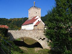
- The Reipoltskirchen moated castle , built in the 12th century, is located on a rock spur above the Odenbach. It was the seat of the Lords of Hohenfels-Reipoltskirchen and was first mentioned in 1276. The system has been largely preserved and restored. It is used by the Reipoltskirchen u. a. as a registry office , the keep is used by tourism as a lookout tower .
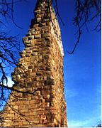
- The moated castle Odenbach at the confluence of the stream in the Glan was built in the second half of the 12th century by the Counts of Veldenz and blown up in 1683 by the troops of the French King Louis XIV . The ruin has a renovated remnant of the keep , which consists of impressive humpback blocks and, as a pond tower, has become the landmark of the municipality of Odenbach.
Web links
- Course of the Odenbach on the map service of the landscape information system of the Rhineland-Palatinate nature conservation administration (LANIS map) ( notes )
- The Odenbach with partial catchment areas on the GeoExplorer of the Rhineland-Palatinate water management authority ( information )
Individual evidence
- ↑ a b c d Map service of the landscape information system of the Rhineland-Palatinate nature conservation administration (LANIS map) ( notes )
- ↑ a b c d e f GeoExplorer of the Rhineland-Palatinate Water Management Authority ( notes )
- ↑ a b Water Status Report 2010 , Structure and Approval Directorate North (SGD North)
- ↑ Types of flowing water , State Office for the Environment Rhineland-Palatinate
- ↑ Odenbachtal cycle path
- ^ Tour planner Rhineland-Palatinate , The Palatinate.


