
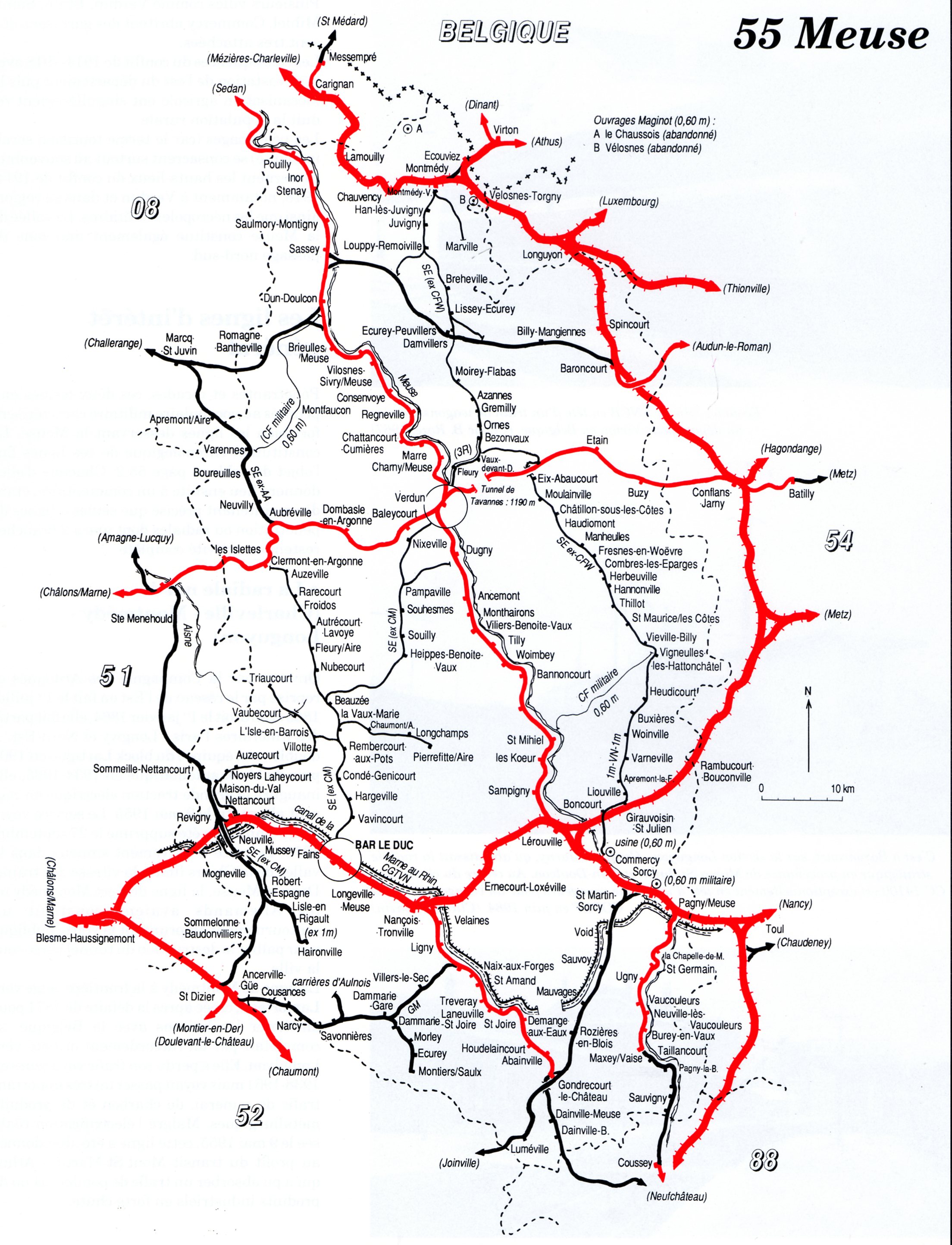
Réseau de la Woëvre

.png)


The Réseau de la Woëvre (colloquially Le Meusien ) was a 149 km long meter-gauge rail network in the French department of Meuse , which was operated from 1914 to 1938. From the 61 km long main line Verdun – Montmédy branched off in Vaux-devant-Damloup a 66 km long branch line to Commercy. Before and during the Battle of Verdun , the northern sections of the route were expanded by the German armed forces and used as an army field railway .
Route
The Réseau de la Woëvre with a gauge of 1000 mm was a railway network that was built in the Meuse department and operated between 1914 and 1938 by the Société Générale des Chemins de Fer Économiques (SE). It comprised four sections with a total length of 149 km:
- Meter gauge
- Verdun - Vaux-devant-Damloup - Montmédy (61 km), opened in 1914, closed in 1938
- Vaux-devant-Damloup - Commercy (66 km), opened in 1914, closed in 1938
- Standard gauge
- Robert-Espagne - Haironville (11 km), opened in 1933, closed in 1971
- Aubréville - Varennes-en-Argonne (11 km), opened in 1918, closed in 1937
history
Approval
The construction and operation of the meter-gauge local railway was approved on June 7, 1907 by the law on the declaration of the public benefit of the establishment of a local railway network in the department of Meuse, the so-called Réseau de la Woëvre, consisting of the two lines Verdun-Montmédy and Commercy-Verdun .
construction
The construction time was 7 years. The rails came from the steelworks in Vireux-Molhain near Givet and the switches from a factory in Anzin in the north . Three custom-made crossings were also ordered to allow the Douaumont fort's narrower Decauville line to cross the meter- gauge railway.
The 600,000 wooden sleepers were made in sawmills in the area. In order to remove the ballast necessary for the track construction, a large gravel pit was created near Damvillers, where there are ponds today. A total of 26 engineering structures had to be erected, 16 of which were 2 to 4 meters high, and 10 bridges with 6 to 30 meters span. There were also 83 culverts and 19 canal penetrations as well as 68 level crossings.
Installation
The local railway was put into operation in sections in 1914:
- Commercy - Fresnes-en-Woëvre (44 km): February 28, 1914
- Fresnes - Vaux-devant-Damloup - Verdun (36 km): March 21, 1914
- Vaux-devant-Damloup - Montmédy (45 km): April 19, 1914
First World War
After the First World War broke out after the assassination attempt in Sarajevo on June 28, 1914 , the train was used by the French military to bring troops and supplies from Verdun to Montmédy and to transport the injured in the opposite direction to the French hospitals in Verdun. As the German armed forces advanced westwards, the French destroyed the standard-gauge railway tunnel in Montmédy on the night of August 26-27, 1914 on their retreat. This led to considerable transport difficulties until German railway pioneers laid a standard gauge makeshift line through the urban area of Montmédy.
The northern part of the meter-gauge local railway was operated from 1915 by the German armed forces with the help of conscripted civilian personnel and prisoners of war. The military trains ran during the day mostly in the association of two or more trains, each with up to three locomotives to Damvillers because further south sections for the scheduled railway operations were too close to the front. Trains mostly drove on sight using the so-called convoy procedure . At night there were also special military trips with unlit night trains between Damvillers and Moirey and occasionally even as far as Azannes.
The German armed forces built several meter-gauge branch lines: the most important of these began at km 39.5 between Lissey and La Petite Lissey and led from there to the southwest to Romagna, where there was a connection to the standard-gauge main line.
post war period
The Société Générale des Chemins de Fer Économiques (SE) took over the business in 1922. In the post-war period, from 1919 to 1924, large quantities of building materials were transported along the route for the reconstruction of the destroyed buildings. The trains therefore ran according to the schedule as mixed goods and passenger trains, which required numerous shunting maneuvers in the stations in order to couple or uncouple other freight wagons. Because of this and because the top speed was limited to 12 km / h, the journeys were very time-consuming. A one-way trip from Bréhéville train station to Verdun took almost two hours. The main source of income was freight transport, which can also be seen in the spartan equipment of the local railway cars: there were only wooden benches, no heating from the locomotive, insufficient lighting and no toilets.
Decline and shutdown
Since the economic viability was called into question by rising inflation, the operating company merged on June 1, 1923 with the operators of the local railway lines south-west of Verdun. The merged company acquired more modern rail vehicles, especially railcars, which were then in circulation between Montmédy and Bar-le-Duc. On June 20, 1938, operations largely ceased and the assets were sold. The liquidation was not yet complete with the outbreak of World War II in 1939. Only after the end of the Second World War was the company completely wound up in 1946 .
Railway stations and bridges
Montmédy – Verdun railway stations and bridges |
photos | State of preservation of the station buildings and notes |
|---|---|---|
| Montmédy-Échange | _la_gare_avant_l%27arriv%C3%A9e_du_ministre.jpg) |
Receive |
| Montmédy-Ville |  |
During the First World War, numerous locomotives were stationed in Montmédy to transport weapons, ammunition, supplies and soldiers to the front. The station building has been preserved at today's sports field. |
| Han-lès-Juvigny | Receive | |
| Louppy - Remoiville |  |
|
| Dodge Jametz |  |
|
| Brandeville |  |
The wooden station building, built by the German army, was acquired after the war by Mr. Hugbourg from Brandeville. He dismantled it to rebuild it in the Paris area. |
| Bréhéville |  |
|
| Lissey |  |
During the First World War, a branch line ran from Lissey to Romagne, one of two stations on the main line, through which a significant proportion of the supplies and troop transport for the entire northern Verdun front as well as the transport of the wounded to hospitals within the Reich was handled. |
| Branch line to Romagne |  |
At Romagne and Deutsch-Eck there was a reloading station to the standard gauge full line |
| Damvillers | .jpg) |
There was a concrete water tower with an accompanying small pump room. The women's and men's toilets stood next to the station building that is still preserved today . In the post-war period, an Arnold Jung locomotive from 1898 was jacked up on a pile of sleepers using jacks for maintenance over a temporary track section. The Borsig locomotive used for mixed trains for passenger and freight traffic had significant steam leaks. |
| Rail connection to Étraye | The rail connection to Etraye was built by the German military. | |
| Moirey flabas |  |
|
| Azannes | On July 22, 1915, the meter gauge track at Azannes was temporarily destroyed by French shells. The station building is still preserved today . | |
| Gremilly | Receive | |
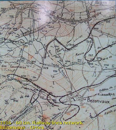
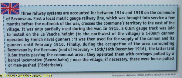
| Ornes | At Ornes and Bezonvaux, the French military moved a 600 mm Decauville line from the meter-gauge railway to the height of La Vauche northwest of Bezonvaux in 1915, in order to install a 140 mm cannon there, which was operated by French naval gunners. The railway was used to transport ammunition until February 1916. When the German army from the end of February to 15./16. Occupied the Bezonvaux area on December 31 , 1916, it laid further 600 mm field railway tracks , on which the lorries were pulled by motor locomotives (benzene railway), pulled by horses ( horse-drawn railway ) or pushed by hand ( conveyor railway ) . The villages and their station buildings have not been rebuilt as so-called village détruits to this day. | |
| Bezonvaux | ||
| Vaux-devant-Damloup | .jpg) |
Receive |
| Fleury-devant-Douaumont |  |
Although the village, which had 400 inhabitants before the First World War, was completely destroyed in the war, there was a scheduled stop in the SE timetable until the line was closed in 1938. The station building was still preserved in the 1950s. Later, in the 1960s, the Mémorial de Verdun was built on the station grounds. |
| Pont de la Galavaude over the Meuse | .jpg) |
|
| Verdun |  |
|
Vaux – Commercy railway stations and bridges |
photos | State of preservation of the station buildings and notes |
| Vaux-devant-Damloup | ||
| Eix-Abaucourt | _-_Gare_Meusienne.jpg) |
|
| Moulainville | _l%27ancienne_gare.JPG) |
Receive |
| Manheulles | _-_La_Gare.jpg) |
Receive |
| Fresnes-en-Woëvre | _-_La_Gare_(en_achevement).jpg) |
|
| Combres-sous-les-Côtes | _-_La_Gare.jpg) |
Receive |
| Herbeuville | _-_La_Gare.jpg) |
|
| Thillot |  |
Receive |
| Saint-Maurice-sous-les-Côtes | _-_La_Gare_(Edition_Brul).jpg) |
Receive |
| Vigneulles-lès-Hattonchâtel |  |
Receive |
| Buxières | _-_La_Gare.jpg) |
|
| Woinville | .jpg) |
In Woinville there was also a locomotive shed operated by the Americans for their field railroad with a gauge of 600 mm. |
| Varneville | _-_La_Gare.jpg) |
|
| Boncourt-sur-Meuse | _-_La_Gare_de_Woevre_02.jpg) |
|
| Canal de l'Est |  |
The innovatively constructed reinforced concrete bridge was destroyed between 1940 and 1946, probably during the Second World War. |
| Commercy |  |
The station building was demolished between 1968 and 1973. |
Locomotives
Shortly before the start of the First World War, the Decauville company delivered twelve brand new locomotives between August 27, 1913 and May 4, 1914. They could be withdrawn to the routes southwest of Verdun before they could have been confiscated by the German military. The German armed forces then used small Belgian steam tram box locomotives and steam locomotives brought in from the Harz Mountains in Germany and built a large wooden shed at Montmédy-Ville station as a railway depot.
| Manufacturer | Wheel alignment | photos | Remarks |
|---|---|---|---|
| Decauville N ° 0662-0673 from 1913 | 1'C n2t | .jpg) |
N ° 3801-3812 of the SE |
| Hohenzollern No. 4814 from 1918, HK 111 | B'B n4vt Mallet |  |
Locomotive of the Härtsfeldbahn |
| Borsig No. 5466 from 1905, HK 117 | B'B n4vt Mallet | _%27Braunschweig%27_of_the_Gernrode-Harzgeroder_Eisenbahn_(GHE)_on_military_duty_in_Montm%C3%A9dy.jpg) |
Braunschweig locomotive of the Gernrode-Harzgeroder Eisenbahn-Gesellschaft (GHE) during a military operation in Montmédy. Société des Economiques N ° 4818, later Chemin de fer du Nord-Est N ° 202. |
| Jung and Güstrow | B'B n4vt Mallet | _01.jpg) |
At least two mallet locomotives of the Nordhausen-Wernigeroder Railway (NWE) , front left and rear right in the locomotive shed |
_02.jpg) |
Belgian box locomotives with leader , d. H. Two locomotives with drivers and two stokers per train |
Field railways


.jpg)
During the First World War, there were military field railways operated by the German armed forces with a gauge of 600 mm along the route . In the Thilwald there was even an intersection between the Romagne – Azannes field railway and the meter-gauge railway.
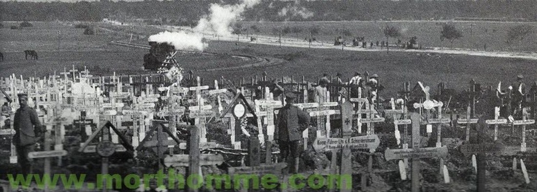
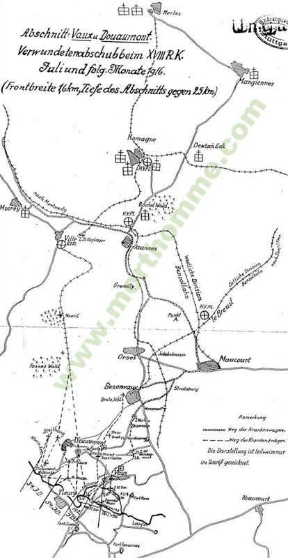
From May 25 to July 13, 1916, benzene and narrow-gauge railroads were used to transport the wounded from the Bavarian infantry division off Verdun. The transport of the wounded from the main first aid station in Ville-devant-Chaumont took place with the narrow-gauge railway via the main first aid station of the Royal Bavarian Company No. 2 IB in Romagne, where there were various field hospitals in which up to 1200 seriously and lightly wounded were treated every day.
Web links
Individual evidence
- ↑ Verdun (Rive Droite) 1915, in Campagne 1914-1918 - Historique des 39 e et 239 e Régiments d'Artillerie de Campagne. Printed by J. Coubé et Fils, Nancy, 1934 and Extrait de la carte au 80,000 e du Service Géographique de l'Armée.
- ↑ Tronçon Vaux – Verdun
- ^ Carte departementale, 55 Meuse
- ↑ IGN map from 1950 and aerial photos from 1950 to 1965.
- ^ A b Meuse-Argonne offensive, map showing daily position of front line: Map Room G-3, GHQ, May 24, 1919.
- ↑ a b c d e f g Lissey - Pendant la guerre. During the First World War.
- ↑ a b c d Stefan Schweitzer: Excursus: Dr. med. Alfred Bauer - doctor in Deutsch-Eck.
- ↑ Montmédy-Échange and Montmédy-Ville on a blurred aerial photo from July 26, 1927.
- ↑ a b c Lissey - Apres la guerre. After the First World War.
- ↑ a b Photo of the railways at the Romagne military cemetery near Deutsch-Eck.
- ^ Deutsch-Eck - pioneer station, warehouse and hospital.
- ↑ a b c d e Brandeville - Le chemin de fer
- ^ SE Meuse
- ↑ a b Henri Domengie: Les petits trains de jadis: L'Est de la France, Breil-sur-Roya. Editions du Cabri, 1992.
- ↑ Approximate route Verdun – Vaux-devant-Damloup – Montmédy on Google Maps.
- ↑ Approximate route Vaux-devant-Damloup - Commercy on Google Maps.
- ↑ FAQS: Société Générale des Chemins de Fer Économiques.
- ↑ "Loi d'declarant utilite publique l'établissement, dans le departement de la Meuse, d'un reseau de chemins de fer d'iteret local, dit réseau de la Woëvre, compose des deux lignes de Verdun a Montmedy et de Commercy a Verdun. ”In: Bulletin des lois de la République française. June 13, 1907. Retrieved May 23, 2021.
- ↑ Alphonse à Douaumont, 1919.
- ↑ a b Lissey - Le Meusien. Before the First World War.
- ↑ The History of the Meusien: Before the Storm. and L'histoire du Meusien: Avant la tourmente.
- ↑ L'histoire du Meusien: Le déclin.
- ↑ Stefan Schweitzer: Deutsch-Eck - la Belle Croix - revolving door of the Verdun front.
- ↑ 1m Montmedy-Verdun track. Damage to the track from shells near Azannes . BayHStA, Staudinger Collection 19586.
- ↑ 1916 - 60 cm Railway lines network Bezonvaux – Ornes. and Three railway systems are accounted for between 1914 and 1918 on the commune of Bezonvaux. In: Verdun - Destroyed Villages: Bezonvaux - Ornes.
- ↑ La batterie de la vauche.
- ↑ The History of the Meusien: The War. and L'histoire du Meusien: La guerre.
- ↑ Gerald Stempel: Mallet Locomotive 3 - Does this locomotive still exist?
- ↑ Une photo de Montmédy?
- ^ Pierre Adnet: Le Chemin de Fer au Pays de Montmedy / 150 ans d'histoire. Autoédition, 2007, No. 1285/08.
- ↑ Thilwald: Crossing of the Romagne Azannes field railway with 1 m track. BayHStA, Staudinger Collection 19476, July 13, 1916.
- ^ Sketch for the evacuation of the wounded of the Bavarian Infantry Division from Verdun.
- ^ Section Vaux and Donaumont. Wounded deportation in the XVIII RK July and the following months 1916.
Coordinates: 49 ° 12 ′ 40.6 ″ N , 5 ° 28 ′ 28.8 ″ E