
Röthenbach (Allgäu)
| coat of arms | Germany map | |
|---|---|---|
_COA.svg)
|
Coordinates: 47 ° 37 ' N , 9 ° 58' E |
|
| Basic data | ||
| State : | Bavaria | |
| Administrative region : | Swabia | |
| County : | Lindau (Lake Constance) | |
| Management Community : | Argental | |
| Height : | 663 m above sea level NHN | |
| Area : | 14.96 km 2 | |
| Residents: | 1885 (Dec. 31, 2019) | |
| Population density : | 126 inhabitants per km 2 | |
| Postal code : | 88167 | |
| Area code : | 08384 | |
| License plate : | LI | |
| Community key : | 09 7 76 124 | |
| Community structure: | 17 parts of the community | |
| Association administration address: | Mühlenstrasse 1 88167 Röthenbach (Allgäu) |
|
| Website : | ||
| Mayor : | Stefan Höß ( FW ) | |
| Location of the municipality of Röthenbach (Allgäu) in the district of Lindau (Lake Constance) | ||
 _in_LI.svg) |
||


Röthenbach (Allgäu) ( western Allgäu Reth e bach ) is a municipality in the Swabian district of Lindau (Lake Constance) and the seat of the administrative community Argental .
geography
Location and district
Röthenbach (Allgäu) is located in the Allgäu region , more precisely in the Westallgäu . The community lies between the Alps and Lake Constance . There is only the district Röthenbach (Allgäu).
Parish parts
The municipality has 17 officially named municipal parts (the type of settlement is given in brackets ):
|
|
|
Neighboring communities
| Argenbühl | Gestratz | |
| Heimenkirch |
.svg)
|
Grünenbach |
| Lindenberg in the Allgäu | Hamlet-Simmerberg |
history
Until the 18th century
At Röthenbach and Oberhäuser there were remains of Roman burgi , tower-like buildings that were erected to strengthen the border fortifications between the forts at a distance of about 1.5 to two kilometers with an almost square base area of ten to twelve meters on a side.
Röthenbach was first mentioned in a document in 861 AD.
When the monastery Mehrerau near Bregenz was founded in 1097 by Count Ulrich X. von Bregenz, the place belonged to his property. After the Udalriche , the founders of the monastery, died out, Mehrerau became the house monastery of the subsequent ruling dynasty, the Counts of Montfort . The monastery developed into the most important landlord in Röthenbach.
In the 14th and 15th centuries, the place was under the rule of the Counts of Montfort .
On February 1, 1771, the Upper Austrian postal route Bregenz -Weiler / Dorenwaid-Kempten was opened, which led from Weiler via Röthenbach to Kimpflen.
19th and 20th centuries
Since the peace treaties of Brno and Pressburg in 1805, the place has belonged to Bavaria. In the course of the administrative reforms in Bavaria , today's municipality was created with the municipal edict of 1818 .
The construction of the Rentershofen railway embankment between 1847 and 1853 brought the community an economic boom due to the large number of workers working there. The Röthenbach (Allgäu) station in the Oberhäuser district was opened on October 12, 1853.
In 1893 the Röthenbach – Weiler railway line was opened and in 1901 the connection to Scheidegg .
Population development
| date | Residents |
|---|---|
| 1890 | 1099 |
| 1910 | 1322 |
| 1954 | 1624 |
| 1970 | 1491 |
| 1987 | 1007 |
| 1991 | 1666 |
| 1995 | 1655 |
| 2000 | 1722 |
| 2005 | 1744 |
| 2010 | 1694 |
| 2015 | 1769 |
Between 1988 and 2018, the community grew from 1,581 to 1,845 by 264 inhabitants or 16.7%.
politics
| Local council election | FWG | Green |
|---|---|---|
| 2020 | 63.8% | 36.2% |
mayor
Stefan Höß (Free Voters) has been mayor since the 2014 local elections.
coat of arms
The coat of arms was assigned to Röthenbach in 1979. It is divided - at the top split by silver and red, on top of it a key and a sword in mixed up colors crossed at an angle. At the bottom in silver a three-lobed golden fringed red storm flag with three golden rings.
Architectural monuments

Economy and Infrastructure
Economy including agriculture and forestry

In 1998, according to official statistics, there were 250 in the manufacturing industry and no employees in the field of trade and transport who were subject to social security contributions at the place of work. In other economic sectors, 72 people were employed at the place of work subject to social security contributions. There were a total of 567 employees at the place of residence subject to social security contributions.
There were six companies in the manufacturing sector and three in the construction sector. In addition, in 1999 there were 54 farms with an agricultural area of 880 ha.
traffic
Röthenbach is connected to federal highways 12 , 32 and 308 ( German Alpine Road ) via state roads, each of which passes a few kilometers away. The nearest motorway is just under 20 km away ( A 96 near Wangen im Allgäu ).
Röthenbach has a train station on the Allgäu Railway ( Munich - Lindau ), which is just under two kilometers to the west in the Oberhäuser district.
education
In 1999 the following institutions existed:
- Kindergartens: 50 kindergarten places with 50 children
- Elementary school: one with four teachers and 99 students
societies
The club system of Röthenbach particularly includes groups of interests focused on music.
- Kapellenverein St. Christophorus Auers
The Kapellenverein St. Christophorus Auers is one of the youngest associations in Röthenbach. In the mid-1990s, the association was founded by some residents of the Röthenbach district of Auers , with the aim of building their own prayer chapel. Construction work began in 1996, most of which was voluntary. On July 20, 1997, the chapel was finally inaugurated.
The rosary is prayed there in the evening on the first Sunday of the month . There is also an annual chapel festival in summer. - Counterpoint
The mixed choir counterpoint was brought into being in 1992 by the then Röthenbach organist Gudrun Schmitt. The twelve founding members had their first appearance on April 20, 1992 in the parish church of St. Martin.
In 2008 the choir had 34 members who meet regularly in the Röthenbach parish hall. - Music band Röthenbach 1840 e. V.
The Röthenbach band was first mentioned in writing in 1840. The Happareuten musician Josef Mader is passed down as the founder of the association .

Giesenberg

Oberschmitten on the Röthenbach

Church in Röthenbach (Allgäu)
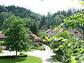
Röthenbach place
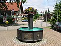
Röthenbach center of Brunnen
Stony 146


Web links
- Community website
- Entry on the coat of arms of Röthenbach (Allgäu) in the database of the House of Bavarian History
Individual evidence
- ↑ "Data 2" sheet, Statistical Report A1200C 202041 Population of the municipalities, districts and administrative districts 1st quarter 2020 (population based on the 2011 census) ( help ).
- ^ Community Röthenbach (Allgäu) in the local database of the Bavarian State Library Online . Bayerische Staatsbibliothek, accessed on August 18, 2019.
- ↑ The Romans on Lake Constance and Allgäu . P. 13–16, here P. 14. In: Werner Dobras: Chronologie des Landkreis Lindau . Verlag W. Eppe, 1985. ISBN 3-89089-004-0
- ↑ From the history of the Röthenbach community (written by G. Kleber, elementary school teacher in Röthenbach) ( Memento from October 24, 2007 in the Internet Archive )
- ↑ https://www.merkur.de/bayern/kommunalwahl-bayern-2020-gemeinderatswahlen-gemeinden-results-13595423.html
- ↑ List of all Röthenbach's associations ( memento of the original from January 17, 2013 in the Internet Archive ) Info: The archive link was automatically inserted and not yet checked. Please check the original and archive link according to the instructions and then remove this notice.
Auers | Bauschwanden | Brettweg | Egg | Giesenberg | Happareute | Harratried | Hell | Kimpflen | Oberhäuser | Oberschmitten | Rentershofen | Röthenbach (Allgäu) | Schmalenberg | Steinegaden | Vogelsang | Wigglis
