
Sant'Antonino (Corsica)
|
Sant'Antonino Sant'Antulinu |
||
|---|---|---|
|
||
| region | Corsica | |
| Department | Upper Corsica | |
| Arrondissement | Calvi | |
| Canton | Calvi | |
| Community association | Calvi Balagne | |
| Coordinates | 42 ° 35 ' N , 8 ° 54' E | |
| height | 138-521 m | |
| surface | 4.1 km 2 | |
| Residents | 127 (January 1, 2017) | |
| Population density | 31 inhabitants / km 2 | |
| Post Code | 20220 | |
| INSEE code | 2B296 | |

Sant'Antonino ( Corsican Sant'Antulinu ) is a French commune with 127 inhabitants (as of January 1, 2017) in the Haute-Corse department in the Corsica region ; it belongs to the Arrondissement of Calvi and the Canton of Calvi .
Neighboring municipalities of Sant'Antonino are Pigna in the north, Santa-Reparata-di-Balagna in the east, Cateri in the south and Aregno in the west. Sant'Antonino is located at an altitude of 479 m on a mountain ridge. Because of the excellent panoramic view, it is also known as the "Balagne Eagle's Nest". The place can only be visited on foot. The townscape is characterized by a multitude of narrow streets with high granite houses and vaults. As a former fortified stronghold of the Counts Savelli, Sant'Antonino also served as a refuge from pirates for the inhabitants of the Balagne.
Population development
| year | 1962 | 1968 | 1975 | 1982 | 1990 | 1999 | 2008 | 2016 |
| Residents | 109 | 121 | 113 | 79 | 60 | 77 | 93 | 124 |
Attractions
- Église de l'Annonciation (11th century) outside the village
- neighboring Chapelle de Confrérie
- Chapelle Sainte-Anne et des Bergers, below the village
- Chapelle Lavasina on the Piazza di u Duttore Paul Savelli Spinosi

Ascent to the upper town

Streets and arched passages in the upper town

Arched gallery

Opposite the Chapelle Lavasina

Old oven

Looking east

View to the southeast
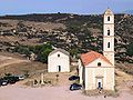
Eglise de l'Annonciation and Chapelle de Confrérie

Eglise de l'Annonciation

Chapelle Sainte-Anne et des Bergers

Chapelle Lavasina


