
Shimane Prefecture
|
Shimane-ken 島 根 県 |
|
|---|---|
 .svg) |
|
| Basic data | |
| Administrative headquarters : | Matsue |
| Region : | Chūgoku |
| Main island : | Honshu |
| Area : | 6,708.07 km² |
| Water content: | 2.7 % |
| Residents : | 673,891 (October 1, 2019) |
| Population density : | 100 inhabitants per km² |
| Counties : | 5 |
| Municipalities : | 19th |
| ISO 3166-2 : | JP-32 |
| Governor : | Tatsuya Maruyama |
| Website: | www.pref.shimane.lg.jp |
| Symbols | |
| Prefecture flag : |
 |
| Prefecture tree : | Japanese black pine |
| Prefecture flower : | Shrub peony |
| Vogel prefecture : | swan |
| Fish prefecture : | Flying fish |
| Prefecture song : |
Usumurasaki no sanmyaku ("light purple mountain range") |
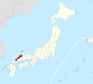
The Shimane Prefecture ( Jap. 島根県 , Shimane-ken ) is a prefecture of Japan . It is located in the Chūgoku region on the island of Honshū . The seat of the prefecture administration is Matsue .
geography
Shimane is one of the two most rural and sparsely populated prefectures in Japan , along with the neighboring prefecture of Tottori . Shimane extends roughly from southwest to northeast and is separated from the economically much more important east coast by the Chūgoku Mountains. The prefecture is located on the Sea of Japan and is bordered by Yamaguchi Prefecture to the south and Hiroshima Prefecture to the east . In the northeast is the Tottori Prefecture. Most of the prefecture's larger cities and towns are located on the coast of the Sea of Japan, which is also where the prefecture's north-south main traffic axis runs.
The prefecture has the following border points:
- in the east: 133 ° 23'13 "east longitude - Okinoshima-chō
- in the west: 131 ° 40'04 "east longitude - Tsuwano-chō
- in the south: 34 ° 18'09 "north latitude - Yoshika-chō
- in the north: 37 ° 14'39 "north latitude - Okinoshima-chō
On the mainland, the eastern and northern border points are perceived by the city of Matsue :
- 133 ° 19'37 east longitude
- 35 ° 36'21 "north latitude
The territory of the prefecture also includes the Oki Islands, some 70 kilometers off the coast in the Sea of Japan . The former province moved from Tottori Prefecture to Shimane in 1904 .
politics
(as of May 14, 2019)
- Jiyūminshutō Shimane kengikai giin renmei (~ "Association of LDP MPs [in] the Shimane Prefectural Parliament "): 16
- Shimane kengikai jiyūminshutō (~ " LDP [in] Shimane Prefectural Parliament "): 10
- Minshu kenmin club ("Democratic Prefectural Citizens Club "; with KDP , DVP ): 5
- Kōmeitō (non-attached): 2
- CPY (non-attached): 2
- Other non-affiliated lots: 2
Zembē Mizoguchi retired from Shimane in 2019 after three terms as governor. In the uniform regional elections in April 2019 , the former MIC official Tatsuya Maruyama, supported by the LDP Shimane, prevailed against the LDP Japan-supported Seiji Ōba and two other candidates as successors. At the same time, the LDP won an absolute majority with 19 seats in the 37-member prefectural parliament, twelve seats went to candidates without party nominations.
In the national parliament , Shimane is represented by two directly elected members of the Shūgiin , for the Sangiin Shimane forms a common constituency with the neighboring Tottori. The Shūgiin constituencies , originally three after the electoral reform of the 1990s and now two , went to the LDP in the 2017 election as well as continuously since 1996, namely to Hiroyuki Hosoda , head of the LDP's strongest faction since 2014, and Wataru Takeshita , brother of the former Party chairman Noboru Takeshita , who took over his brother's former faction in 2018. In the Sangiin, Shimane lost its independent representation in the 2016 and 2019 elections and is now part of the joint single-mandate constituency of Tottori-Shimane. However, the LDP uses the tokutei-waku system for proportional representation, which was introduced in 2019 , to give the LDP prefectural associations affected by the constituency association secure seats in the proportional representation: In 2019, Yasushi Miura from Shimane was given second place on the LDP list in the proportional representation constituency.
Shimane is one of the financially weakest prefectures in the country and can only cover around a quarter of its theoretically calculated financial needs from its own income.
tourism
The main tourist attraction in Shimane is the Izumo-Taisha shrine, located near the city of Izumo , one of the oldest Shinto shrines in Japan. In the area of the prefecture there are also some ski areas, which in winter attract skiers and snowboarders from nearby Hiroshima .
Administrative division
When the prefectures were set up during the Meiji Restoration in 1889, Shimane was formed from the independent city of Matsue, 8 small towns belonging to the county and 269 villages (in 16 counties). As a result of incorporations and mergers, the number of municipalities fell to 19 by 2011 (1950: 247 - 1954: 158 - 1956: 75 - 1970: 1959). The prefecture is divided into 8 independent cities ( Shi ), 10 small towns ( Chō ) and a village ( Son ), the latter organized in 5 districts ( Gun ). Matsue , the seat of the prefecture administration, has also been a "core city" ( chūkakushi ) since April 2018 .
In the table below, the districts ( 郡 ) are shown in italics, below each (indented) the small towns ( 町 ) and the village ( 村 ) within them. A dependency between rural district and small town can also be seen in the first three digits of the code (1st column). At the beginning of the table are the 4 independent cities.
| code | Surname | Area (in km²) | population | Population density (inh / km²) |
||
|---|---|---|---|---|---|---|
| Rōmaji | Kanji | 01.10.2017 1 | 01.10.2018 3 | 01/10/2015 2 | ||
| 32201 | Matsue- shi | 松江 市 | 572.99 | 204,428 | 206.230 | 359.92 |
| 32202 | Hamada- shi | 浜 田 市 | 690.68 | 55,772 | 58.105 | 84.13 |
| 32203 | Izumo- shi | 出 雲 市 | 624.36 | 172,947 | 171,938 | 275.38 |
| 32204 | Masuda- shi | 益田 市 | 733.19 | 45,911 | 47,718 | 65.08 |
| 32205 | Ōda -shi | 大田 市 | 435.71 | 33,417 | 35.166 | 80.71 |
| 32206 | Yasugi- shi | 安 来 市 | 420.93 | 38.032 | 39,528 | 93.91 |
| 32207 | Gotsu- shi | 江津 市 | 268.24 | 23,582 | 24,468 | 91.22 |
| 32209 | Unnan -shi | 雲南 市 | 553.18 | 37.012 | 39,032 | 70.56 |
| 32340 | Nita-gun | 仁 多 郡 | 368.01 | 12,175 | 13,063 | 35.5 |
| 32343 | Okuizumo-chō | 奥 出 雲 町 | 368.01 | 12,175 | 13,063 | 35.5 |
| 32380 | Iishi-gun | 飯 石 郡 | 242.88 | 4772 | 5031 | 20.71 |
| 32386 | Iinan-cho | 飯 南 町 | 242.88 | 4772 | 5031 | 20.71 |
| 32440 | Ōchi-gun | 邑 智 郡 | 808.63 | 18,286 | 19,443 | 24.04 |
| 32441 | Kawamoto-machi | 川 本 町 | 106.43 | 3183 | 3442 | 32.34 |
| 32448 | Misato-cho | 美 郷 町 | 282.92 | 4534 | 4900 | 17.32 |
| 32449 | Ōnan -chō | 邑 南 町 | 419.29 | 10,569 | 11.101 | 26.48 |
| 32500 | Kanoashi-.gun | 鹿 足 郡 | 643.54 | 13,343 | 14,027 | 21.8 |
| 32501 | Tsuwano- cho | 津 和 野 町 | 307.03 | 7197 | 7653 | 24.93 |
| 32505 | Yoshika-cho | 吉 賀 町 | 336.50 | 6146 | 6374 | 18.94 |
| 32520 | Oki-gun | 隠 岐 郡 | 345.92 | 19,949 | 20,603 | 59.56 |
| 32525 | Ama-cho | 海士 町 | 33.44 | 2296 | 2353 | 70.36 |
| 32526 | Nishinoshima-chō | 西 ノ 島 町 | 55.96 | 2886 | 3027 | 54.09 |
| 32527 | Chibu-mura | 知 夫 村 | 13.70 | 658 | 615 | 44.89 |
| 32528 | Okinoshima- chō | 隠 岐 の 島 町 | 242.82 | 14,109 | 14,608 | 60.16 |
| Shi-bu ( All shi , part of urban districts) | 市 部 | 4299.28 | 611.101 | 622.185 | 144.72 | |
| Gun-bu ( All gun , proportion of counties) | 郡 部 | 2408.98 | 68,525 | 72.167 | 29.96 | |
| 32000 | Shimane-ken (Shimane Prefecture) | 島 根 県 | 6708.26 | 679.626 | 694.352 | 103.51 |
swell
1 Area data from 2017
2 Results of the 2015 census
3 Estimated population 2018
Biggest places
| Census year | Residents | |||
|---|---|---|---|---|
| 2015 | 2010 | 2005 | 2000 | |
| Matsue | 206.230 | 194.258 | 196,603 | 152.616 |
| Izumo | 171,938 | 143,796 | 146.307 | 87,330 |
| Hamada | 58.105 | 61,713 | 63,046 | 47,187 |
| Masuda | 47,718 | 50,015 | 52,368 | 50.128 |
| Yasugi | 39,528 | 41,836 | 43,839 | 30,520 |
| Unnecessary | 39,032 | 41,917 | 44,403 | —— |
| Oda | 35.166 | 37,996 | 40,703 | 33,609 |
| Gotsu | 24,468 | 25,697 | 27,774 | 25,773 |
| Hirata | —— | —— | —— | 29.006 |
November 1, 2004 - The independent city of Unnan is formed from 6 municipalities.
March 22, 2005 - The city of Hirata is incorporated into the city of Izumo .
Population development in the prefecture
| Census year |
Total population |
male population |
female population |
Gender ratio men to 1000 women |
Area in km 2 |
Population density per km 2 |
|---|---|---|---|---|---|---|
| 1920 | 714.712 | 354,959 | 359.753 | 987 | 6618.04 | 108.0 |
| 1925 | 722.402 | 359.987 | 362.415 | 993 | 6618.04 | 109.2 |
| 1930 | 739.507 | 368,888 | 370.619 | 995 | 6618.04 | 111.7 |
| 1935 | 747.119 | 373.292 | 373,827 | 999 | 6624.60 | 112.8 |
| 1940 | 740.940 | 367,855 | 373.085 | 986 | 6624.60 | 111.8 |
| 1945 | 860.275 | 395.360 | 464.915 | 850 | 6624.60 | 129.9 |
| 1950 | 912,551 | 444.355 | 468.196 | 949 | 6626.29 | 137.7 |
| 1955 | 929.066 | 456.730 | 472,336 | 967 | 6625.27 | 140.2 |
| 1960 | 888.886 | 432,481 | 456.405 | 948 | 6625.26 | 134.2 |
| 1965 | 821.620 | 393,670 | 427,950 | 920 | 6625.95 | 124.0 |
| 1970 | 773,575 | 367,658 | 405.917 | 906 | 6626.12 | 116.7 |
| 1975 | 768.886 | 367.060 | 401,826 | 913 | 6626.80 | 116.0 |
| 1980 | 784.795 | 377,499 | 407.296 | 927 | 6627.41 | 118.4 |
| 1985 | 794.629 | 382,893 | 411.736 | 930 | 6628.42 | 119.9 |
| 1990 | 781.021 | 373.618 | 407,403 | 917 | 6626.24 | 117.9 |
| 1995 | 771.441 | 368,789 | 402,652 | 916 | 6706.70 | 115.0 |
| 2000 | 761.503 | 363.994 | 397.509 | 916 | 6707.29 | 113.5 |
| 2005 | 742.223 | 353.703 | 388,520 | 910 | 6707.56 | 110.7 |
| 2010 | 717.397 | 342.991 | 374.406 | 916 | 6707.95 | 106.9 |
| 2015 | 694.352 | 333.112 | 361.240 | 922 | 6708.24 | 103.5 |

Outline of the prefecture

Taikodani Inari Shrine in Tsuwano

Hinomisaki lighthouse

View from the Hinomisaki lighthouse


Web links
Individual evidence
- ↑ GSI - the geographical cornerstones of Shimane Prefecture and its communities (Japan.) Accessed on January 16, 2019
- ↑ Shimane Prefectural Parliament : MPs , MPs by parliamentary group (pdf), accessed on August 9, 2019.
- ↑ 島 根 県 議 選 各 党 議席 . In: NHK Senkyo Web. April 7, 2019, Retrieved May 9, 2019 (Japanese).
- ↑ [1] The municipalities and counties in Shimane Prefecture (in Japan.)
- ↑ Kokudo Chiriin (GSI - Geospatial Information Authority of Japan), 平 成 29 年 全国 都 道 府 県 市区 町 村 別 面積 調 (Nationwide survey of all prefectures and municipalities 2017) , p. 76: 32 Shimane-ken (Japanese), accessed on 1 January 2019
- ↑ e-stat (English), accessed on January 1, 2019
- ↑ 簡 単 検 索 ・ 詳細 検 索 ・ 検 索 サ ン プ ル , accessed January 1, 2019 (Japanese)
- ↑ e-Stat database , accessed on December 16, 2018 (English)
Aichi | Akita | Aomori | Chiba | Ehime | Fukui | Fukuoka | Fukushima | Gifu | Gunma | Hiroshima | Hokkaidō | Hyōgo | Ibaraki | Ishikawa | Iwate | Kagawa | Kagoshima | Kanagawa | Kochi | Kumamoto | Kyoto | Mie | Miyagi | Miyazaki | Nagano | Nagasaki | Nara | Niigata | Ōita | Okayama | Okinawa | Osaka | Saga | Saitama | Shiga | Shimane | Shizuoka | Tochigi | Tokyo | Tokushima | Tottori | Toyama | Wakayama | Yamagata | Yamaguchi | Yamanashi
Coordinates: 35 ° 13 ' N , 132 ° 40' E