
Alfredshof settlement

The settlement Alfredshof , named after Alfred Krupp , is preserved in parts Arbeitersiedlung the company Krupp in Essen district Holsterhausen .
history
The planning of a settlement began in 1891, at the same time as the construction of the Altenhof settlement in Rüttenscheid . With this, Friedrich Alfred Krupp (1854–1902) took up the Krupp house building again, which began around 1860 under his father Alfred Krupp (1812–1887) and was discontinued in 1874 due to financial difficulties. Alfred Krupp had the Westend workers 'colony and the Kronenberg workers' colony built. Even before a project on Altenhof was presented, two projects were published for the Alfredshof settlement, which at the time was still unnamed, both of which initially called the project Kolonie Holsterhausen . Settlement plans were first published in 1891 in Krupp's publication Wohlfahrtseinrichtungen der Kruppwerke in Essen , followed in 1892 by Gussmann.
The Alfredshof was finally built between 1893 and 1918 in various construction phases, with a total of around 1,700 rental apartments. The head of the Krupp construction office, Robert Schmohl , was the architect of the Alfredshof, the largest Krupp estate in Essen from the time before the Second World War . It was named after Alfred Krupp.
The first part of the Alfredshof was built from 1893 to 1899. It was located between Münchener Strasse and Keplerstrasse, on both sides of today's A 40 , which was then replaced by Kruppstrasse. In this way, the workers and residents of the settlement were able to walk to the Krupp factories to the northeast, such as the later Widia on Münchener Strasse. One to four-family houses were built based on the model of English garden cities, similar to the Altenhof estate . The difference to the distant Altenhof was that there were no longer active, i.e. retired Krupp workers. This first section of the Alfredshof settlement was completely destroyed in the Second World War.
After 1907, the Alfredshof was expanded to include large-scale residential complexes for reasons of space: up to three-story apartment blocks with green inner courtyards that were used as a playground and meeting place for residents. There was also a central park. In 1908, the Krupp family gave the Protestant parish a piece of land on Planckstrasse, which was located between the houses currently under construction. According to plans by the architect Carl Nordmann , the Wichernhaus , a place of worship, also used as a multi-purpose building, was built here in 1910 and 1911 .
In the Alfredshof settlement there was originally a house-by-house numbering. On October 9, 1914, the individual streets and squares were given official names, so that the houses were numbered street by street. Several streets are no longer available due to the reconstruction after the Second World War and the extension of the former Kruppstrasse to the federal highway 40 , including the Bessemerstrasse, the Dünkelbergstrasse, the Fittingstrasse, the Großstrasse and the Simsonplatz. Other streets have changed their course, including Asthöwer Strasse and Adolf Schmidt Strasse. During the National Socialist era , Simsonstrasse and Simsonplatz were renamed Gustloffstrasse and Gustloffplatz, respectively (after Wilhelm Gustloff , National Socialist and national group leader of the NSDAP foreign organization in Switzerland).
The furnishings of the houses in Alfredshof were exemplary for the time. The entrances of the semi-detached houses were placed on the opposite sides of the house in order to emphasize the independence of the apartments. Special, mass-produced, affordable furniture was developed. So they were functional, straightforward, robust and without veneer.
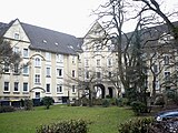
The entire area of the Alfredshof suffered severe destruction in World War II, so that it became the largest contiguous reconstruction area in the region. The only closed area that remained was the Simson Block at the corner of Keplerstrasse and Simsonstrasse. In the late 1950s, the Alfredspark Krupp housing estate was built, and its style of uniformity sets it apart from the Alfredshof.

Part of the Alfredshof around 1915

Simson-Block at the Keplerstraße / corner Simsonstraße as the only preserved closed quarter (2009)
Simson-Block inner courtyard (2009)


Web links
- Description of this sight on the route of industrial culture
- Columnsberger: "Krupp settlements - from workers' houses to Margarethenhöhe" (PDF; 590 kB); accessed on July 11, 2018
Individual evidence
- ^ Erwin Dickhoff: Essener streets . Ed .: City of Essen - Historical Association for City and Monastery of Essen. Klartext-Verlag, Essen 2015, ISBN 978-3-8375-1231-1 .
Coordinates: 51 ° 26 ′ 30.5 ″ N , 6 ° 59 ′ 22.2 ″ E
Visitor center and anchor points (from west to east): Museum of German Inland Shipping | Inner harbor Duisburg | LVR Industrial Museum Oberhausen | Landscape Park Duisburg-Nord | Gasometer Oberhausen | Aquarius Water Museum | St. Antony Hut | Villa Huegel | Nordsternpark | Zeche Zollverein World Heritage Site and Zollverein Coking Plant | Ewald colliery | Marl Chemical Park | Railway Museum Bochum-Dahlhausen | Henrichshütte | Centennial Hall Bochum | Recklinghausen substation | German Mining Museum | Nightingale colliery | Henrichenburg ship lift | DASA | Hansa coking plant | Zeche Zollern II / IV | Hohenhof | Hagen Open Air Museum | Lindenbrauerei Unna | Maximilian Park Hamm
Themed routes (in ascending order by number): 1. Duisburg: City and Harbor | 2. Industrial cultural landscape Zollverein | 3. Duisburg: industrial culture on the Rhine | 4. Oberhausen: Industry makes the city | 5. Krupp and the city of Essen | 6. Dortmund: triad coal, steel and beer | 7. Industrial culture on the Lippe | 8. Erzbahn-Emscherbruch | 9. Industrial culture at Volme and Ennepe | 10. Brine, steam and coal | 11. Early industrialization | 12. The past and present of the Ruhr | 13. On the way to the blue Emscher | 14. Canals and shipping | 15. Lanes in the area | 16. Westphalian mining route | 17. Rhenish mining route | 18. Chemistry, Glass and Energy | 19. Workers' settlements | 20. Entrepreneur villas | 21. Bread, grain and beer | 22. Myth of the Ruhr Area | 23. Parks and Gardens | 24. Industrial nature | 25. Panoramas and Landmarks | 26. Sacred buildings | 27. Iron & Steel | 28. Water: works, towers and turbines | 29. Bochum - industrial culture in the heart of the district | 30. Gelsenkirchen | 31. Industrial Culture and Bauhaus Route | by bike

Villa Huegel ![]() |
Hill park |
Brandenbusch settlement |
Station hill |
Parking garage hill |
Wolfsbachtal waterworks |
Evangelical Church Becoming |
ETUF |
Family cemetery Krupp |
Altenhof I |
Alfried Krupp Hospital |
Altenhof Chapel |
Beneficiaries |
Altenhof II settlement
|
Hill park |
Brandenbusch settlement |
Station hill |
Parking garage hill |
Wolfsbachtal waterworks |
Evangelical Church Becoming |
ETUF |
Family cemetery Krupp |
Altenhof I |
Alfried Krupp Hospital |
Altenhof Chapel |
Beneficiaries |
Altenhof II settlement ![]() |
Krupp official houses |
Church of the Redeemer |
Friedrichshof settlement |
Margarethenhöhe
|
Krupp official houses |
Church of the Redeemer |
Friedrichshof settlement |
Margarethenhöhe ![]() |
Halbach hammer |
Memorial plaque Humboldtstrasse |
Heimaterde settlement |
Alfredshof settlement |
Luisenhof settlement |
Pottgießerhof settlement |
Grunertstrasse tunnel |
West office building |
Friedrichsbad | Former beer hall settlement Kronenberg |
United Helene-Amalie colliery |
Locomotive factory and works railway Krupp |
Memorial stone fulling mill |
Eighth mechanical workshop , today Colosseum Theater |
Press and hammer plant east |
Alfred Krupp monument at the Marktkirche |
WIDIA factory | former Krupp headquarters |
Crucible Cast Monument |
Headquarters Krupp |
Thyssenkrupp Quarter
|
Halbach hammer |
Memorial plaque Humboldtstrasse |
Heimaterde settlement |
Alfredshof settlement |
Luisenhof settlement |
Pottgießerhof settlement |
Grunertstrasse tunnel |
West office building |
Friedrichsbad | Former beer hall settlement Kronenberg |
United Helene-Amalie colliery |
Locomotive factory and works railway Krupp |
Memorial stone fulling mill |
Eighth mechanical workshop , today Colosseum Theater |
Press and hammer plant east |
Alfred Krupp monument at the Marktkirche |
WIDIA factory | former Krupp headquarters |
Crucible Cast Monument |
Headquarters Krupp |
Thyssenkrupp Quarter