
Pottgießerhof settlement

The Pottgießerhof housing estate is a late Krupp housing estate built in the mid-1930s in the west of Essen 's Frohnhausen district . Today it belongs to the route of industrial culture .
history
On the area of today's housing estate there were once manors of the Overrath settlement.
Pottgießerhof
The name Pottgießerhof goes back to one of four farms in the former Overrath settlement. This Pottgießerhof was mentioned for the first time in 1220 in the bailiwick role of Count von Isenberg . It was subject to the Oberhof Ehrenzell as treatment goods . Treatment means that the rider has a hereditary right of use, which he can also have shared with his wife. The Pottgießerhof, once also known as the Jungehof , was sold to the Pottgießer family in 1562 by the Essen citizen Conrad Wiederbach for 625 Thaler, waiving the right of treatment. In 1668 Dietherich Pottgießer was named as the sitter of the 33 acre farm. In 1826 Eberhard Pottgießer was the owner. In 1830 the yard was around 67 acres when the burdens on the yard were relieved. In 1834, the farmer Wilhelm Pottgieser replaced the fiscal burdens on the farm, becoming the unrestricted owner. From 1871 onwards, Hermann Becker from Bedingrade married into the farm until 1937. In that year Hermann Becker sold the farm to Friedrich Krupp AG for planning the housing estate , which demolished it. The homestead was on the site of the former club house “Eigen Scholle”, directly to the east next to today's parking lot for the Helmut Rahn sports complex .
Overrathhof
Hof Overrath, after Overrathstrasse has been named in the settlement since 1936, was also subject to Oberhof Ehrenzell as treatment goods. In 1668 the owner of the 46 acre farm was Hermann Overradt. In 1841 the farmer Heinrich Overradt replaced the fiscal burdens on the now 70 acre farm, which made him the full owner. In 1902 the last farmer, Wilhelm Philipp Overrath, sold the farm to the Mülheimer Bergwerks-Verein .
The settlement in the 1930s
With the Pottgießerhof settlement, the Krupp company had 288 apartments built for employees from 1935 onwards, which were already occupied in 1936. There is no uniform architecture in the Pottgießerhof as in other settlements, as several private architects were involved here. The houses are built open or closed, depending on the type of terrain. The overall picture, divided at right angles, is rather simple, but partly also characterized by Art Nouveau and reflects the zeitgeist of the 1930s. In 1938, Loerbrokstrasse, located in the settlement, was named after Wilhelm Loerbrok , the judiciary, authorized signatory of the Krupp company and city councilor (from 1867 to 1876) . Born in Soest in 1820 , he returned there for family reasons after his career in Essen and died as a lawyer and notary.
Reconstruction until today
After the reconstruction of the settlement, which was destroyed in World War II, starting in 1954, it was renovated and modernized in the 1990s. The single coal stoves used up to then were replaced by central gas boilers per apartment block and two small apartments were made into one large apartment several times. A little later, the settlement changed in parts to different owners. Today the Pottgießerhof offers 38 residential units with green spaces and several playgrounds.
On the south-eastern edge of the settlement, on the corner of Onckenstrasse and Pottgießerstrasse, there is a boulder that is entered in the list of natural monuments in Essen .

Uhlenhautstrasse
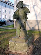
Goose rider sculpture in Schliemannstrasse

Boulder, natural monument


Individual evidence
- ↑ a b Land register 1668 in the Essen monastery
- ↑ a b Erwin Dickhoff: Essener streets . Ed .: City of Essen - Historical Association for City and Monastery of Essen. Klartext-Verlag, Essen 2015, ISBN 978-3-8375-1231-1 .
- ^ National newspaper (Essen) - What was accomplished in 1936 ; Essen, January 13, 1937
- ^ Westdeutsche Allgemeine Zeitung of October 18, 2008, Essen regional section
Web links
Visitor center and anchor points (from west to east): Museum of German Inland Shipping | Inner harbor Duisburg | LVR Industrial Museum Oberhausen | Landscape Park Duisburg-Nord | Gasometer Oberhausen | Aquarius Water Museum | St. Antony Hut | Villa Huegel | Nordsternpark | Zeche Zollverein World Heritage Site and Zollverein Coking Plant | Ewald colliery | Marl Chemical Park | Railway Museum Bochum-Dahlhausen | Henrichshütte | Centennial Hall Bochum | Recklinghausen substation | German Mining Museum | Nightingale colliery | Henrichenburg ship lift | DASA | Hansa coking plant | Zeche Zollern II / IV | Hohenhof | Hagen Open Air Museum | Lindenbrauerei Unna | Maximilian Park Hamm
Themed routes (in ascending order by number): 1. Duisburg: City and Harbor | 2. Industrial cultural landscape Zollverein | 3. Duisburg: industrial culture on the Rhine | 4. Oberhausen: Industry makes the city | 5. Krupp and the city of Essen | 6. Dortmund: triad coal, steel and beer | 7. Industrial culture on the Lippe | 8. Erzbahn-Emscherbruch | 9. Industrial culture at Volme and Ennepe | 10. Brine, steam and coal | 11. Early industrialization | 12. The past and present of the Ruhr | 13. On the way to the blue Emscher | 14. Canals and shipping | 15. Lanes in the area | 16. Westphalian mining route | 17. Rhenish mining route | 18. Chemistry, Glass and Energy | 19. Workers' settlements | 20. Entrepreneur villas | 21. Bread, grain and beer | 22. Myth of the Ruhr Area | 23. Parks and Gardens | 24. Industrial nature | 25. Panoramas and Landmarks | 26. Sacred buildings | 27. Iron & Steel | 28. Water: works, towers and turbines | 29. Bochum - industrial culture in the heart of the district | 30. Gelsenkirchen | 31. Industrial Culture and Bauhaus Route | by bike

Villa Huegel ![]() |
Hill park |
Brandenbusch settlement |
Station hill |
Parking garage hill |
Wolfsbachtal waterworks |
Evangelical Church Becoming |
ETUF |
Family cemetery Krupp |
Altenhof I |
Alfried Krupp Hospital |
Altenhof Chapel |
Beneficiaries |
Altenhof II settlement
|
Hill park |
Brandenbusch settlement |
Station hill |
Parking garage hill |
Wolfsbachtal waterworks |
Evangelical Church Becoming |
ETUF |
Family cemetery Krupp |
Altenhof I |
Alfried Krupp Hospital |
Altenhof Chapel |
Beneficiaries |
Altenhof II settlement ![]() |
Krupp official houses |
Church of the Redeemer |
Friedrichshof settlement |
Margarethenhöhe
|
Krupp official houses |
Church of the Redeemer |
Friedrichshof settlement |
Margarethenhöhe ![]() |
Halbach hammer |
Memorial plaque Humboldtstrasse |
Heimaterde settlement |
Alfredshof settlement |
Luisenhof settlement |
Pottgießerhof settlement |
Grunertstrasse tunnel |
West office building |
Friedrichsbad | Former beer hall settlement Kronenberg |
United Helene-Amalie colliery |
Locomotive factory and works railway Krupp |
Memorial stone fulling mill |
Eighth mechanical workshop , today Colosseum Theater |
Press and hammer plant east |
Alfred Krupp monument at the Marktkirche |
WIDIA factory | former Krupp headquarters |
Crucible Cast Monument |
Headquarters Krupp |
Thyssenkrupp Quarter
|
Halbach hammer |
Memorial plaque Humboldtstrasse |
Heimaterde settlement |
Alfredshof settlement |
Luisenhof settlement |
Pottgießerhof settlement |
Grunertstrasse tunnel |
West office building |
Friedrichsbad | Former beer hall settlement Kronenberg |
United Helene-Amalie colliery |
Locomotive factory and works railway Krupp |
Memorial stone fulling mill |
Eighth mechanical workshop , today Colosseum Theater |
Press and hammer plant east |
Alfred Krupp monument at the Marktkirche |
WIDIA factory | former Krupp headquarters |
Crucible Cast Monument |
Headquarters Krupp |
Thyssenkrupp Quarter
Coordinates: 51 ° 27 ′ 11 " N , 6 ° 57 ′ 47" E