Six-Fours-les-Plages
| Six-Fours-les-Plages | ||
|---|---|---|

|
|
|
| region | Provence-Alpes-Cote d'Azur | |
| Department | Var | |
| Arrondissement | Toulon | |
| Canton | La Seyne-sur-Mer-2 | |
| Community association | Toulon Provence Méditerranée | |
| Coordinates | 43 ° 6 ′ N , 5 ° 50 ′ E | |
| height | 0-352 m | |
| surface | 26.58 km 2 | |
| Residents | 32,829 (January 1, 2017) | |
| Population density | 1,235 inhabitants / km 2 | |
| Post Code | 83140 | |
| INSEE code | 83129 | |
| Website | http://www.mairie-six-fours.fr/ | |
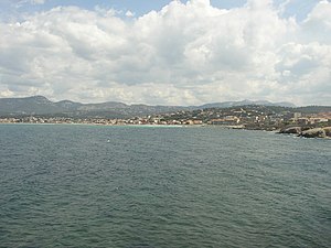
 Six-Fours (and Sanary further to the left) seen from Cap Nègre |
||
Six-Fours-les-Plages (until January 1, 1975: Six-Fours-la-Plage , Provencal Sièis Forns lei Plaias or Sièis Four lei Plaio ) is a French commune with 32,829 inhabitants (as of January 1, 2017) in the department var in the region d'Provence-Alpes-Cote Azur . It belongs to the canton of La Seyne-sur-Mer-2 in the arrondissement of Toulon .
geography
Six-Fours is located between the municipalities of Ollioules , Sanary-sur-Mer and La Seyne-sur-Mer . The name of the community is derived from the Latin Sex Fur or Sex Furni and indicates six positions or fortifications. The highest point of the municipality is 320 meters above sea level near the Cape Pointe du Cap Vieux .
history
Around 600 BC BC people from Asia Minor came ashore near Tauroentum ( Le Brusc ) and founded settlements near the ( Îles des Embiez ). Fearing attacks by local tribes, they built a fortified settlement - surrounded by six fortified positions - on the highest elevation in the area. With numerous attacks by barbarian tribes from the north or the Saracens across the sea, the population was able to withdraw to the fortress, which was further expanded over time. Attackers never succeeded in taking the fortress.
Population development
The population has grown continuously to more than threefold over the past 50 years.
| year | 1962 | 1968 | 1975 | 1982 | 1990 | 1999 | 2006 | 2016 |
| Residents | 9057 | 15,118 | 20,090 | 25,526 | 28,957 | 32,742 | 34,325 | 33,250 |
| Sources: Cassini and INSEE | ||||||||
Attractions
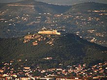
- The Six Fours fortress dominates the townscape. It serves the military as a center for surveillance of the Mediterranean area.
- The Saint-Pierre monastery, which is directly adjacent to the Six-Fours fortress, dates back to the 11th century.
- The Cap Sicié with the Îles des Embiez and the fishing village Le Brusc is in the west and La Seyne-sur-Mer in the east of the headland. This is famous for the original character of its coastal landscape. At its highest point is the Notre Dame du Mai chapel , in which numerous votive images can be seen, commemorating the rescue of seafarers from peril to their lives.
economy
The main economic factors are agriculture and tourism .
Town twinning
- Emmendingen , Baden-Württemberg , Germany (since 1978)
- Zagarolo , Italy , metropolitan city of Rome
Personalities
- Hélène Segara (* 1971), singer, comes from Six-Fours-les-Plages. Your parents live there.
- Franck Esposito (* 1971), swimmer and four-time European champion, grew up in Six-Fours-les-Plages.

